
Impact Of Urban Development To The Communities In George Town Conurbation

Abstract
Drastic increase of urban population has caused cities to grow towards the fringe areas. This is due to increasing of land demand to accommodate the increasing of urban population. Urban area only covers small portion of country’s land area, however the impact of this area is massive mainly due to significant number of population lives within this area. In Malaysia, for example, the size of urban land is less than 10%; however, it accommodates more than 74% of its population. Therefore, it is important to investigate the perception of the community living within affected area. This study used GIS to map the expansion of urban area in the George Town Conurbation, and utilized quantitative method using questionnaire to assess the impact of urban expansion on the communities. Household survey was undertaken in three towns namely Sungai Petani in Kedah, Parit Buntar in Perak and Teluk Kumbar in Pulau Pinang, that has different rate of urbanization. Based on household survey undertaken, it is indicated that different perception was found among communities living within those areas. People who live in less urbanized states welcomed urban development as this was perceived to bring more jobs and economic opportunities into the area. On the other hand, people that had experienced longer period of urbanization were indifferent towards urban development. This is mainly due to congestion and overcrowding caused by urban expansion. It is therefore, important to take into consideration the perceptions of local communities in planning and managing urban spatial growth.
Keywords: CommunityGeographic Information Systemland use changessocio-economyurban expansion
Introduction
Many countries especially in developing nations have experienced rapid urbanization. According
to the United Nations (2014), the number of urban populations in less developed nations is 2.76 billion in
year 2012, increase almost 32% from year 2002. It is expected to raise to 3.33 billion in year 2020. On the
other hand, urban areas are relatively small and it is difficult to accommodate a huge number of urban
populations. Demographia World Urban Areas (2017) reported that urban population density is
approximately 4,000 to 10,000 people per square kilometres where more than half (57%) of the
population are in Asia. China and India are two major countries that contribute to the figure and even so,
Japan, South Korea and Singapore are classified as most urbanized countries in East Asia in demographic
terms (World Bank, 2017). Urban population increased due to migration and growth of population has
denser its urban population density with limited urban land. Urbanization brings positive impact to the
economy of the country. It boosted countries’ economy as urbanization brings many benefits such that it
increases trade, investment and commercial activities. Some developing countries manage to seize this
opportunity and further develop its major city to become megacity in which it can handle major
international commercial activities (Cavallier, 1996). Furthermore, good infrastructures and facilities
were developed to attract trade, investment and business to that city. Additionally, urbanization is
beneficial to urban population in term of more employment opportunities and modern lifestyles offered in
the city (Su, Jiang, Zhang, & Zhang, 2011). However, it is also attracted rural population to migrate into
city in order to seek for better job and lifestyle. This phenomenon has created major challenges to local
authority in handling increasing number of urban population and providing urban services.
Problem Statement
Penang along with Kuala Lumpur, Selangor and Johor has experienced rapid urbanization mostly
due to the industrial activities since 1970s (Ghazali, 1999; Hadi, Idrus, Shah, & Mohamed, 2010). To date, it has contributed 6.6% of Malaysia’s Gross Domestic Product (GDP) in 2015 after Selangor
(22.6%), Kuala Lumpur (15.1%), Sarawak (10.0%), Johor (9.3%) and Sabah (6.6%) (Department of
Statistics Malaysia, 2016). Penang has numerous industrial and commercial activities in which can boost
states economic and have ability to improve public infrastructure that can attract international investors.
These activities provide great employment opportunities that consequently draw rural population
to migrate into the Penang state (Samat, Ghazali, Hasni, & Elhadary, 2014). However, Penang built up
area is quite small as compare to the Penang rapid urbanization and number of urban population. Analysis
done by Demographia World Urban Areas (2017) stated that Penang has the highest urban population
density with 4,800 people per square kilometres in Malaysia (see Table
population in Kuala Lumpur is the highest in Malaysia, Penang population density is the highest in
Malaysia due to its small urban area.
Research Questions
Urbanization in Penang is resulted from rapid development that occurs in the George Town city,
and has spread its development to the neighbouring regions. George Town city is a capital city for Penang
State and also one of major attractions for visitors where George Town has been listed as a UNESCO
World Cultural Heritage Site in 2008 (UNESCO, 2018). These factors have escalated nearby areas to
develop with better public amenities and services to support George Town city. Business and commercial
activities are keen to grow within this area due to increasing demand from population (Mahamud, Samat,
& Noor, 2016). Due to better facilities and rapid development, private developers started to explore new
potential development area for accommodating the increasing of urban population (Hasni & Samat, 2015)
Consequently, Penang Island with good facilities and many employment opportunities have
increased land value and housing prices which has made neighbouring regions especially in districts at
mainland area become an alternative option for people to live (Hasni & Samat, 2015). People started to
look for cheaper developed area and these opportunities have been grab by private developers to venture
potential area in mainland districts. The existence of First Penang Bridge and Ferry commuting from
George Town to Seberang Perai have increased development in the Northern Penang neighbouring area
and Second Penang Bridge has increased development in the Southern Penang neighbouring area. These
great road networks have eased people to commute from mainland to island. On the other hand, the
existence of North-South Highway and Butterworth-Kulim Highway connecting Penang and
neighbouring regions from Kedah and Perak has attracted people to stay in the neighbouring regions and
commuted to work on a daily basis. The development in the neighbouring regions will increase rapidly as
the demand for housing and public infrastructure raised. New constructions of residential and business
units and administrative complex foster the economy with the regions (Deng, Wang, Hong, & Qi, 2009).
This development however, brings some consequences to the community living in the regions (Su et al.,
2011).
Purpose of the Study
Urbanization has been a major challenge in Malaysia due to rapid increasing of urban population
in all major urban areas (World Bank, 2017). Major urban areas are Kuala Lumpur, Johor Bharu, and
George Town. In order to implement proper plan and manage urban area, Federal Department of Town
and Country Planning Malaysia (FDTCP, 2010) has used the term conurbation to describe a boundary
comprising of cities and expanded develop areas that have combined and formed a continuous urban area
(FDTCP, 2010). Thus, George Town and its neighbouring region was referred as George Town
Conurbation. This study, therefore, monitored its expansion and accessed the perception of its community
on development and the consequences that arise in their surroundings.
Research Methods
The Study Area
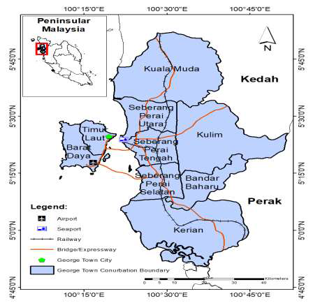
The study was carried out to track urbanization in the George Town Conurbation, Malaysia.
Federal Department of Town and Country Planning Malaysia has included Kuala Muda, Kulim, Bandar
Baharu (from Kedah), and Kerian (from Perak) into George Town Conurbation boundary together with
all districts in Penang (FDTCP, 2010). George Town Conurbation is located in the northwest coast of
Peninsular Malaysia, with an area approximately 3,938 square kilometers (see Figure
Conurbation has experienced tremendous urban development due to the rapid development from George
Town city (FDTCP, 2010). George Town city gives many benefits especially in cooperating with nearby
states and regional countries. George Town city has used its strategic location by strengthens its role in
the northern region and become major contribution to the development of the country. Consequently, the
Northern Region urban conurbation with George Town city in the middle has stretched to Kuala Muda in
the north, Kulim in the east and Kerian in the south as shown in Figure
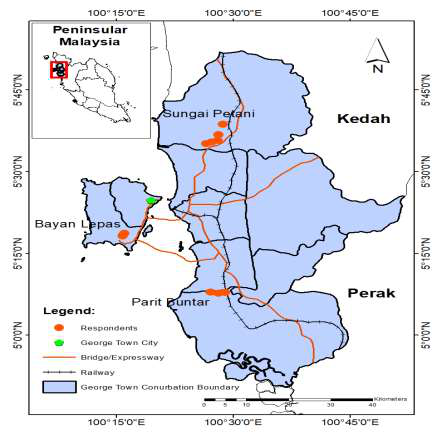
used to map and monitor urban expansion since 2002 extracted from satellite images classified using
Erdas Imagine 2014. Household survey using questionnaire was conducted in order to evaluate the
perception and views of local communities living near or surrounding developed area. The identified
urban areas are Parit Buntar (in Kerian, Perak) and Sungai Petani (in Kuala Muda, Kedah). Communities
from Teluk Kumbar (in Bayan Lepas, Penang) are included to evaluate their perspective and to assess the
differences of viewpoint between Penang societies and neighbouring (Kedah and Perak) societies.
Data Used in The Study
Raw satellite images of the study areas from Landsat 7 acquired in 2002, 2006, 2010 and from
Landsat 8 obtained in 2014 were downloaded from the United States of Geological Survey (USGS)
(USGS, 2014). Those satellite images were selected taking into consideration minimum cloud covers.
Those images were pre-processed and referenced on UTM-47N with spatial resolution of 30 meter x 30
meter. Landsat images that covers all the George Town Conurbation are from the 128-056 path and row.
Erdas Imagine 2014 software was used to pre-processed and reclassified using maximum likelihood
supervised classification method. Four types of land cover activities was extracted from those satellite
images. Land cover maps were then combined with GIS database using ArcGIS 10.1 software (ESRI,
2012). Quantitative data was acquired through household survey which involved 550 respondents selected
using cluster sampling (see Figure
local community living within urbanized areas. Out of the 550 respondents, 208 (41.6%) were from Parit
Buntar, 214 (42.8%) were from Sungai Petani and 128 (25.6%) were from Teluk Kumbar.
Land Cover Data
Using Erdas Imagine 2014, image enhancement has been applied to all the satellite images to
improve images quality for good land cover information extraction. Then, the produced images were
classified into four major land cover, which are Agricultural Area, Forest Area, Built-up Area, and Water
Body Area. The classified images were validated and assessed it accuracy by comparing it with the land
use datasets obtained from FDTCP together with ground checking. Once the images achieved a satisfied
accuracy, the land cover will be extracted for the study.
Herein, the extracted land cover were evaluated with the reference of land use of year 2002, 2006,
2010, 2014 obtained from Federal Department and Penang State Department of Town and Country
Planning (FDTCP, 2015; PSDTCP, 2016), and Google Earth (http://earth.google.com) spatial images
from multiple years. Classified images for each year are validated by selecting 200 randomly stratified
sampling points. Overall accuracy of classified images was 80% and above (Table
were then processed and imported in ArcMap 10.4 for GIS land cover mapping.
Findings
Classified Image
The study obtained four land cover maps as shown in Figure
comparison. This table stated that urban area has expanded by 13.4% from year 2010 to 2014 which is the
highest contribution to total change of urban area. Urban development in GeorgeTown conurbation has
been growing steadily. As the demand for housing and related services increased, urban areas expanded
towards the Bayan Lepas located at south of Georgetown in Penang Island. While in the mainland, the
development of Butterworth expanded along North-South Expressway toward Sungai Petani, Kedah in
the North and Parit Buntar, Perak in the South. This phenomenon will continue as demand for housing
and other activities are increasing. Figure
especially at Batu Kawan experienced significant increase of new development. The existence of Penang
Second Bridge connecting Teluk Kumbar (Penang Island) and Batu Kawan (Penang Mainland), which
operated in early 2014, has escalated development in southern part of Penang Mainland. This
development, however, has caused forest area to decrease by 7.2% within the year 2010 to 2014 (Refer to
Table
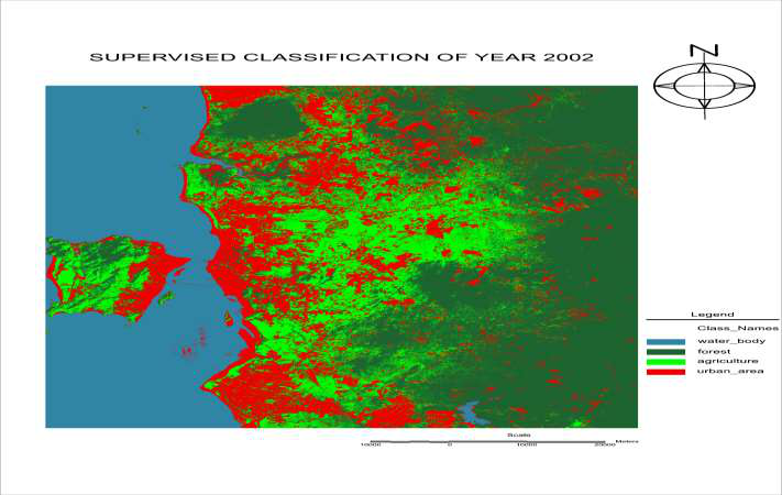
Despite of decreasing of forest area, agricultural area shows a huge increment with 55% in total.
This may be due to majority of the local communities are continuing to cultivate on their agriculture land
that still have high demand from the country. Sea water has been calculated together with other water
bodies. Therefore, the change of the water body area is probably due to the rise or fall of sea tides, and
has not been given much attention in this study. This significant finding should provide invaluable
information to responsible planners and decision makers, which also can be served as an alert for them to
prepare appropriate enforcement in managing newly-developed urban area from encroaching into forest
area.
Perception of Local Communities on Urban Development
Based on the result from survey undertaken, communities living in Parit Buntar and Sungai Petani
(new developed urban area) have welcomed the urban development around their area where 49% and
49.6% respectively agreed to the question asked (Table
will generated more employment opportunities, enhances transportation and road network, improves
public amenities, and escalates the living standards of the residents. Urban development also created
opportunities for non-agriculture employment, thus enable the local communities to set up another linked
local businesses that generates income for living.
However, only 32.1% respondents in Teluk Kumbar (developed urban area) agreed to the
urbanization developed around their area. This is probably due to the communities in Teluk Kumbar has
experienced some negative consequences such as congestion and rise of residential land at their area.
Furthermore, 64.1% of respondents in Teluk Kumbar has agreed that migration of newcomers to their
area has occurred and 34.4% agreed that residents have sold their land or house due to the high offer from
urban developers.
Communities in Sungai Petani were also started to experience congestion due to migration of new
dwellers where 57% of respondents agreed when the question was asked. They also agreed to the question
where some of local communities started to sell their agriculture land and converted into residential or
commercial land due. Despite of all consequences that they have experienced due to rapid urbanization,
communities at all the study area agreed that economic at their area has escalated and communities began
to improve their life.
Conclusion
This study concludes that communities in Parit Buntar and Sungai Petani are still struggling and
adapting the spillover of rapid development from Penang compare to the communities in Teluk Kumbar.
A more effective policy response to address the circumstances for Kerian and Kuala Muda local
authorities should be adopt such as an integrated policy approach done by the City Council of Penang
Island and Seberang Perai Municipal Council to manage rapid urban development. This study has shown
that physical development within George Town Conurbation has spilled to neighbouring region, thus
affected the communities. This finding should be further explored towards policy formulation such that
urbanization can be planned and communities are safeguarded.
Acknowledgments
This research was funded by the Ministry of Higher Education (MoHE) through the Fundamental Research Grant Scheme (FRGS) grant number 203/PHUMANITI/6711472. The authors also wish to thank Universiti Sains Malaysia for providing facilities to carry out this research.
References
- Cavallier, G. (1996). Urbanization in developing countries, Urbanisme, 4-11
- Demographia World Urban , Areas. (2017). Built up urban areas or world agglomerations: 13th annual edition, retrieved from www.demographia.com/db-worldua.pdf
- Deng, J. S.Wang, K.Hong, Y.Qi, J. G. (2009). Spatio-temporal dynamics and evolution of land use change and landscape pattern in response to rapid urbanization, Landscape and Urban Planning, 92, 187-198
- Department of Statistics Malaysia, (2016). Malaysia’s GDP by States, 2010-Kuala Lumpur, released on 30 September 2016, 2015
- ESR, I. (2012). Introducing ArcGIS , accessed date 15 january 2017, 10(1), https://www.esri.com/news/arcnews/spring12articles/introducing-arcgis-101.html
- FDTC, P. (2010). National Physical Plan-Kuala Lumpur: Federal Department of Town and Country Planning, Malaysia, 2
- FDTC, P. (2015). Federal Department of Town and Country Planning, Malaysia
- Ghazali, S. (1999). Socio-economic changes in the peri urban villages in Penang, Malaysia, Unpublished PhD Thesis, University of Leeds, Leeds
- Hadi, A. S.drus, S.Shah, A. H. H.Mohamed, A. F. (2010). Malaysian urbanization transition: from nascent, pseudo to livable mega - urban region, Malaysian Journal of Environmental Management, 11(1), 3-13
- Hasni, R.Samat, N. (2015). Predicting Seberang Perai housing land pattern in Proceedingss of International Conference on Development and Socio Spatial Inequalities 2015, 216-223, 2017
- Mahamud, M. A.Samat, N.Noor, N. M. (2016). Identifying factors influencing urban spatial growth for the George Town Conurbation, Planning Malaysia Journal, 14(5), 95-106
- PSDTC, P. (2016). Laporan Tinjauan Rancangan Struktur Negeri Pulau Pinang Penang State Department of Town and Country Planning, 2020(Kajian Semula)
- Samat, N.Ghazali, S.Hasni, R.Elhadary, Y. (2014). Urban expansion and its impact on local communities: a case study of Seberang Perai, Penang Malaysia, Pertanika . Soc.. Sci. & Hum, 22(2), 349-367
- Su, S.Jiang, Z.Zhang, Q.Zhang, Y. (2011). Transformation of agricultural landscapes under rapid urbanization: a threat to sustainability in Hang-Jia-Hu region, China, Applied Geography, 31, 439-449
- United , Nations. (2014). World Urbanization Prospects: The 2014 Revision, Department of Economic and Social Affairs, Population Division, -ROM Edition, CD
- Scientific and Cultural Organization – UNESC, O. (2018). Melaka and : from, https://whc.unesco.org/en/list/1223
- United States Geological Survey (USGS), (2014). Earth Explorer, Maps, Imagery and Publications, retrieved on 29 July from, 2015, http://earthexplorer.usgs.gov/
- World , Bank. (2017). Malaysia among most urbanized countries in East Asia, retrieved on 21 June from, 2016, http://www.worldbank.org/en/news/feature/2015/01/26/malaysia-among-most-urbanized-countries-in-east-asia
Copyright information

This work is licensed under a Creative Commons Attribution-NonCommercial-NoDerivatives 4.0 International License.
About this article
Publication Date
23 September 2019
Article Doi
eBook ISBN
978-1-80296-067-9
Publisher
Future Academy
Volume
68
Print ISBN (optional)
-
Edition Number
1st Edition
Pages
1-806
Subjects
Sociolinguistics, linguistics, literary theory, political science, political theory
Cite this article as:
Samat*, N., & Mahamud, M. A. (2019). Impact Of Urban Development To The Communities In George Town Conurbation. In N. S. Mat Akhir, J. Sulong, M. A. Wan Harun, S. Muhammad, A. L. Wei Lin, N. F. Low Abdullah, & M. Pourya Asl (Eds.), Role(s) and Relevance of Humanities for Sustainable Development, vol 68. European Proceedings of Social and Behavioural Sciences (pp. 749-759). Future Academy. https://doi.org/10.15405/epsbs.2019.09.81