
Analysis Of The Burnability Of The Territory Of The Jewish Autonomous Region


Abstract
The article considers the pyrological situation on the territory of the Jewish Autonomous Region located in the Russian Far East. The author presented the statistics of forest fires by year, the principal forest fires causes, and the forest fund of the Jewish Autonomous Region according to the degree of natural fire danger, taking into account the pyrological features of the forests in the region, forest types and land categories. The paper covers the fires statistics of the forest fund territory. Statistics data collected during a long time (from 2005 to 2019) is presented. The author identified periods of increased fire danger and the main factors of forest fires. As a result of the work carried out, the months with the highest pyrologic load were specified (March - November). The hugest number of fires occurs in April, May, July, October, and November. The analysis showed that forest fires reach their maximum peaks in May and October. The paper highlights the principal causes of forest fires (the presence of sources of ignition and burning (dry grass, leaves) in forests, high temperatures, and low rainfall, as well as the hugest influx of people into the woods during this period, for the collection of wild plants.
Keywords: Burnability, fire hazard situation, natural factor
Introduction
One of the most significant functions of the forest is oxygen production. In addition, the influence of forests on the water regime, soil protection from water and wind erosion, mudslides and landslides, reducing the effects of drought and dry winds, restraining the movement of mobile sands, preventing the destruction of river banks and lakes, precipitation of dust particles from the atmosphere, the release of phytoncides, noise absorption and, very importantly, a beneficial effect on human health is crucial. In addition to all this, forests are a source of various natural resources, which turn out to be fundamental for many industries in the national economy.
The problem of forest fires, prediction, and economic and environmental consequence assessment has always existed. It remains relevant and attracts the attention of various authorities, departments, and, in general, the region's population. Annual forest fires harm all elements of nature: the atmosphere, hydrosphere, biosphere, soil, flora, and fauna.
Forest fires are a forceful natural and anthropogenic factor that significantly changes the functioning and forest condition. Forest fires trigger environmental damage, the economy, and often human lives are at risk. For countries where forests cover a large area, forest fires are a national problem, and the damage inflicted on the real sector of the economy amounts to tens and hundreds of millions of dollars a year. It should be noted that the real economic damage from a forest fire consists not only of the damage caused to the forest, industrial, and other structures but also of the costs connected directly with extinguishing.
According to the Information system for remote monitoring of forest Fires of the Federal Forestry Agency, the total area of forest fires since the beginning of this year in Russia amounted to 10.2 million hectares, which is more than the territory of Latvia or Estonia. As of July 22, the area of active forest fires in Russia exceeded 785,000 hectares. In 2020 and 2019, forests burned 16.5 million hectares, in 2018 - 15.4 million hectares. On average, about 15 million hectares of forest are burned out every year.
Scholars point out that one of the parameters determining the fire danger of any territory is the pyrological characteristics of weather and climate conditions (Nikonov & Polikarpov, 2020).
According to statistics, the most fire-hazard areas on the territory of the Russian Federation are the forests of the Central, North-Western, and Far Eastern regions (Vorobyev, 2004). In the Far Eastern Federal District, weather and climate conditions vary greatly, so it is essential to plan work in emergencies caused by large forest fires. In addition, anthropogenic loads, which are increasing every year, also play a crucial role in the occurrence of fire-hazard situations on the territory of the Far Eastern Federal District. Due to this factor combined with weather conditions, there may be an increase in the areas exposed to fire (Andreev, 2003; Vorobyev, 2004).
To date, the extent of the impact of fires on forest ecosystems has not been sufficiently studied, and their consequences are underestimated. Regular monitoring of forest fires is carried out only in actively protected areas of the country's forest fund (Anderson, 2002; Viegas, 1999). In the unguarded territories of the northern regions of Siberia and the Far East, forest fires are practically not registered and are not extinguished. The development of operational methods for predicting and assessing wildfires is one of their main problems in the complex of ensuring fire and environmental safety of the territory (Baranovskiy & Yankovich, 2018; Makarov & Malykh, 2019).
According to literary sources in the Amur region, the first anthropogenic fires began to occur about 400-600 thousand years ago. And at present, the burnability of the forests of the Amur region, including the Jewish Autonomous Region, has a negative growth trend, which can be explained by the conditions prevailing by the beginning of the XXI century in the forest fund: a decrease in the area of virgin forests, where the burnability is lower than in forests traversed by fires and logging (Sokolova, 2009, 2013). Intensive harvesting has recently predetermined a high degree of fire hazard in the Far Eastern region. Due to the increased development of the forest area, an increasing number of anthropogenic sources of fire have recently played an important role. Social responsibility for caring for nature is decreasing, wanting to make a profit, despite the negative environmental consequences that may arise. The fight against forest fires occupies a significant place in forest management throughout the region. The ecological damage is expressed in the transformation of the state of ecosystems. Forest fires losses also have economic nature (Komin & Komin, 2020).
The Jewish Autonomous Region is located on the eastern edge of the largest continent of Eurasia in the south of the Russian Far East. The area of the JAR is 36.3 thousand square kilometers. The population is 176.6 thousand people; the population density is 4.8 people/ km2. There are two cities, 11 urban-type settlements, and 99 rural settlements on the territory. The region is divided into five administrative districts (Birobidzhansky, Leninsky, Obluchensky, Oktyabrsky, Smidovichsky). The municipal structure of the JAR includes 35 municipalities, including five districts, one urban district, 12 urban, and 17 rural settlements. Forests are one of the main riches of the region. As shown in Table 1.
Problem Statement
According to the state forest register on 01.01.2018, the total area was 2108.0 thousand hectares which was 58% of the region's territory. The significant type of vegetation of the JAR is forest.
Usually, the fire-hazard period on the territory of the JAR begins on April 10 and lasts until the end of October - November. The hugest number of forest fires in the JAR occurs in spring and autumn. The peak of the most fire danger falls on the third decade of April and the first decade of May (especially in Birobidzhansky and Oktyabrsky districts). 63% of the total number of forest fires falls on this season. Almost all of these fires have human-caused nature. There are practically no lightning discharges (lightning) during these periods (in the spring before the leafing of tree species and in the autumn after the defoliation and the drying of green grass).
During the summer period (from the second half of June and in the first half of August), the quantity of wildfires decreases radically due to monsoon rains.
In the autumn months, starting from October (especially the second decade), the risk of wildfires is associated with the deadwood formation, the presence of wind, and the annealing of dry grass by the population (Glagolev, 2015) see Table 2.
Research Questions
In spring and autumn, the situation is predetermined by the facts that in spring (before the leafing of tree species and the appearance of green herbage) and autumn (after the defoliation and the drying of green grass), massive forest fires occur. In addition, the fire situation is hugely complicated that during these periods of the season (especially in spring), there are strong winds. The speed of flame propagation, under such conditions, can exceed 15 km/h. The forest fund of the Jewish Autonomous Region is divided into five classes according to the degree of natural fire danger, taking into account the pyrological features of the forests in the region, forest types, and land categories.
I class. It is a very high level of fire danger. Lands not covered with forest (burning, wastelands, and cuttings), rare-coniferous plantations and meadows, as well as coniferous young and severely damaged tree stands, which occupy 9.2% of the forest fund of the region;
II class. It is a high level of fire danger. Dry and periodically dry, cedar-oak forests and oak-larch forests occupy 14.7% of the forest fund;
III class. It expresses an average fire danger. It includes fresh cedar bushes with lime, oak, and yellow birch, which make up 44.3% of the forest fund;
IV class. It shows a moderate fire danger. It contains moist cedar forests, mossy-fern, and birch-aspen forests making up 30.3% of the forest fund;
V class. It describes a low level of fire danger. It includes alder forests, peat bogs, and larch forests, making up 1.5% of the forest fund (Prikaz..., 2008).
Along with the fire-hazard features of the combustible forest materials, weather and climatic conditions are the second factors determining the fire danger level and forests burnability in the region.
Climate features affect the level (or degree) of drought, representing a balance of factors of humidification and drying of combustion conductors (Kulik, 2002).
Purpose of the Studу
The purpose of the paper is to identify the most fire-hazard periods on the territory of the Jewish Autonomous Region and the most significant causes of fires.
Research Methods
A statistical analysis of forest fires on the territory of the Jewish Autonomous Region was carried out for the period from 2005 to 2019, see Table 3.
Findings
Forest fires occur in the Jewish Autonomous Region annually, during which forest resources and animal and plant species are burned out or damaged. If the number of arisen fires directly depends on the anthropogenic factor and the weather conditions at the moment they happen, so a burned area mainly depends on climate conditions, the availability of combustible material, and the timeliness of extinguishing, as well as the availability of sufficient forces and means to eliminate the fire. Thus, studying the forest fires dynamics on the territory of the JAR from 2005 to 2018, we can see that the number of fires gradually increased from 95 to 168.
In the JAR, in addition to two natural factors (recurrent droughts and an abundance of flammable and combustible materials), there is a third factor - an anthropological one that determines the extreme fire danger in forests. It is characterized by the high presence of anthropogenic sources of fire, causing massive fire occurrence. Therefore, an objective analysis of the causes of the fire is of great significance because it allows taking definite measures to eliminate them. The fire-hazard period in the Jewish Autonomous Region lasts more than six months (from April to October). Forest burnability in the JAR is one of the highest indicators in Russia (Kogan & Glagolev, 2014).
Catastrophic, large-scale fires occurring in vast territories have a 22-year periodicity. We can trace large fires in the region in 1932, 1954, 1976, and 1998. In recent decades, large fires with less area coverage happened every eight years (1980, 1988, 1996, 2004, and 2021).
There have been repeated fires through overgrown cuttings on the territory for more than half a century. An important role, in addition to climatic factors in this area and the weak fire resistance of coniferous undergrowth, is also promoted by the anthropogenic factor - the clutter of cuttings. The specific natural conditions of the territory distinguish it from other areas from the point of view of fire danger. These include insufficient humidification in the autumn-winter-spring period, the development peculiarities in the atmospheric processes, extensive coniferous-deciduous forests and long periods of low humidity in the air and soil, and dry winds. Recently, the number of fires caused by thunderstorms has increased in the region. The increase in their number correlates with an increase in average daily temperatures and a decrease in precipitation, explained by a large-scale Arabian anticyclone pumping heated air into the territory. The excess of the long-term average indicators for the number of days with thunderstorms ranges from 11% to 26% (Ivanova & Ivanov, 2020) see Table 4.
The hugest number of forest fires in the JAR occurs in spring and autumn. These periods account for up to 63% of the total number of fires during the fire season. All of them occur due to human-caused accidents because, during these periods (in the spring before the leafing of tree species, in the autumn after the fall of foliage and the drying of green grass), there are practically no lightning discharges (lightning).
In the summer, the grass-mixed ground cover in the vegetating state sharply slows down the spread of the fire edge. The mass accidents of fires in summer are observed only in abnormally dry seasons, which happen 2-3 times in 15 years.
A massive outbreak of forest fires in spring and autumn is predetermined by the fact that in the spring before the leafing of tree species and the appearance of green herbage, and in the autumn after the fall of foliage and its drying, we observe the most extreme fire danger in forests. The fire situation is also sharply complicated during these periods of the season (especially in spring) when there are strong winds. Under such conditions, the speed of fire propagation can exceed 15 km/h. The hugest number of fires occurs in the spring period (Fig. 1).
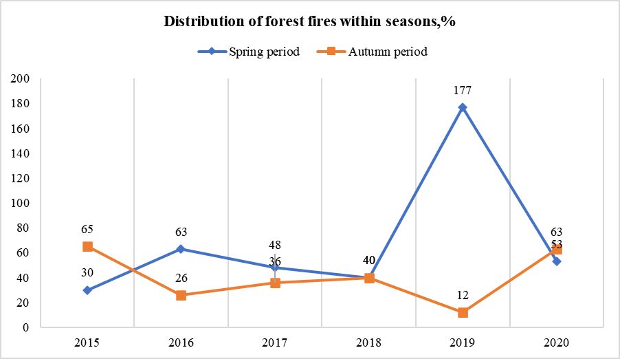
Fires occurring from March to November are severest in April, May, July, October, and November. Forest fires reach their maximum peaks in May and October.
During his period, in addition to the presence of sources of ignition and burning in forests (dry grass, leaves), high temperatures, and low rainfall, there is an influx of a large number of people into nature, as various wild plants begin to grow. In spring, the relative humidity in the daytime is less than 30%, which creates favorable conditions for the development of atmospheric drought and the occurrence and spread of fires; vegetation burns especially intensely in April and May.
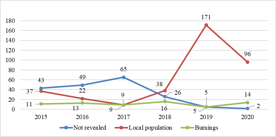
In the JAR, along with two natural factors - recurrent droughts and an abundance of flammable and combustible materials - the third factor determining the extreme fire danger in forests is the high presence of anthropogenic sources of fire that cause massive fires. Therefore, an objective analysis of the causes of fires is of great significance because it allows taking definite measures to eliminate them. Forest fire statistics data indicate that the main culprit of forest fires in the JAR is a person (Fig.2) (Kogan & Glagolev, 2014).
An objective analysis of the causes of fires is crucial because it allows taking definite measures to eliminate them.
Data from long-term forest fire statistics indicate that the main culprit of forest fires in the JAR is a person (non-compliance by the population and vacationers, fishers, and hunters, including employees of logging organizations with fire safety rules in the forest). He is responsible for more than 90% of all fires in forests. At the same time, the most visited places are zones in a 10-kilometer area around settlements, and a 3-kilometer strip along the roads, where an overwhelming number of fires occur (up to 70%).
It is difficult to establish the causes of forest fires, so the percentage of fires for unknown reasons remains high, especially in remote and hard-to-reach areas.
Forest fires, which are recorded annually on an area more than three times larger than the officially felled area, significantly contribute to the deterioration of the state of the forest fund and constitute the main impact factor on forestry.
It is significant to zone the forest fund according to fire danger degree, the extinguishing priority, and the level of the costs for forest protection from fires to ensure the effective management of the forest fire protection system. We need to establish maximum permissible norms of the burnability of various forest formations and categories of protective forests.
The current practice of forest reproduction in the JAR generally corresponds to the all-Russian standards of forest restoration in the taiga zone. Practically due to natural regeneration in the region, the restoration of more than 80% of the forest lands not covered with the forest is ensured. The main obstacle to this process is forest fires. In this regard, we should direct most of the funds assigned for reforestation to ensure the fire safety of forests.
Conclusion
Thus, effective fire monitoring management in a specific territory - the Russian part of the Middle Amur region - requires an automated system development for calculating and forecasting software parameters. It is necessary to analyze existing assessment systems that predict similar situations in the Far East, including the Jewish Autonomous Region, to develop an approach that lets professionals assess a current situation and foresee future ones.
References
Anderson, К. A (2002). Model to predict lightning-caused fire occurrences. International Journal of Wildland Fire, 1(3), 163-172.
Andreev, Yu. A. (2003). Vliyaniye antropogennykh i prirodnykh faktorov na vozniknoveniye pozharov v lesakh i naselennykh punktakh [The influence of anthropogenic and natural factors on the occurrence of fires in forests and settlements]. FSU VNIIPO EMERCOM of Russia. [in Russ.].
Baranovskiy, N. V., & Yankovich, K. S. (2018). Preliminary estimation of forest fire danger using LANDSAT images over Baikal Lake basin forests. Proceedings of UNSP, 108336J.
Glagolev, V. A. (2015). Otsenka i prognoz vozniknoveniya pozharov rastitel'nosti na territorii Yevreyskoy avtonomnoy oblasti [Assessment and forecast of vegetation fires on the territory of the Jewish Autonomous Region]. Khabarovsk. Federal State University "Far Eastern Research Institute of Forestry".
Ivanova, G. A., & Ivanov, V. A. (2020). Zonality of forest fuels and their pyrogenic transformation in pine forests of central Siberia. Lesnoy zhurnal – forestry journal, 4, 9-26.
Kogan, P. M., & Glagolev, V. A. (2014). Osobennosti pozharoopasnykh sezonov v Khabarovskom kraye i Yevreyskoy avtonomnoy oblasti [Features of fire-hazard seasons in the Khabarovsk Territory and the Jewish Autonomous Region]. Fundamental Research, (9), 1549-1553.
Komin, A., & Komin, P. (2020). Forest resources of the Far East, their use and reproduction. International Research Conference on Ecological and Biological Well-Being of Flora and Fauna (EBWFF), 203, 03003.
Kulik, B. B. (2002). Gidrologicheskiy prognoz lesnykh pozharov i ikh predotvrashcheniye [Hydrological forecast of forest fires and their prevention]. Ecological Bulletin of Primorye, (6), 61-69. http://bookre.org/reader?file=76707
Makarov, V. P., & Malykh, O. F. (2019). Influence of Fires on Pine Forest Floristic Diversity of the Eastern Transbaikal Territory. Lesnoy zhurnal – forestry journal, 1, 77-86.
Nikonov, M. V., & Polikarpov, M. I. (2020). Monitoring the impact of major adverse factors on sustainability of Novgorod forests. International scientific and practical conference biotechnology in the agro-industrial complex and sustainable environmental management, 613, 012093.
Prikaz ot 16 dekabrya 2008 g. № 532 «Ob utverzhdenii klassifikatsii prirodnoy pozharnoy opasnosti lesov i klassifikatsii pozharnoy opasnosti v lesakh po usloviyam pogody, a takzhe trebovaniy k meram pozharnoy bezopasnosti v lesakh v zavisimosti ot tselevogo [Order No. 532 of December 16, 2008 "On approval of the classification of natural fire danger of forests and classification of fire danger in forests according to weather conditions, as well as requirements for fire safety measures in forests depending on the purpose of forests, indicators of natural fire danger of forests and indicators of fire danger in forests according to weather conditions"]. (2008). https://pozhproekt.ru/nsis/proch/klass-prirod-opasnosti-lesov.htm
Sokolova, G. V. (2009). Pozharnaya opasnost' territorii Srednego Priamur'ya: otsenka, prognoz, parametry monitoring [Fire danger of the territory of the Middle Amur region: assessment, prediction, monitoring parameters]. IVEP FEB RAS.
Sokolova, G. V. (2013). Razrabotka metodiki lesopirologicheskogo prognoza (na primere Dal'nego Vostoka) [Development of a methodology for forest-based forecasting (based on the Far East)]. Meteorology and Hydrology, (4), 12-18.
Viegas, D. X. (1999). Comparative study of various methods of fire danger evaluation in southern Europe. International Journal of Wildland Fire, 4(9), 235-246.
Vorobyev, Y. L. (2004). Lesnyye pozhary na territorii Rossii: Sostoyaniye i problemy [Forest fires in Russia: Status and problems]. D EXPRESS.
Copyright information

This work is licensed under a Creative Commons Attribution-NonCommercial-NoDerivatives 4.0 International License.
About this article
Publication Date
03 June 2022
Article Doi
eBook ISBN
978-1-80296-125-6
Publisher
European Publisher
Volume
126
Print ISBN (optional)
-
Edition Number
1st Edition
Pages
1-1145
Subjects
Social sciences, education and psychology, technology and education, economics and law, interdisciplinary sciences
Cite this article as:
Krokhaleva, S. I. (2022). Analysis Of The Burnability Of The Territory Of The Jewish Autonomous Region. In N. G. Bogachenko (Ed.), AmurCon 2021: International Scientific Conference, vol 126. European Proceedings of Social and Behavioural Sciences (pp. 578-586). European Publisher. https://doi.org/10.15405/epsbs.2022.06.64