
Communication Routes In Pskov-Livonian Borderland (14th – Early 15th Centuries)


Abstract
The lack of exclusive transit routes in the Middle Ages in the region of the Velikaya-Narva river basin determined the need to develop an intraregional road network designed to ensure effective administrative and fiscal control over the exploited territories. The development of transport network in the border areas was an important factor in strengthening ties within the region and a decisive factor in case of military or political conflicts. The road functioning was indirectly reflected in reports on military units in the region under study movement in the 14th and early 15th cc. Using the data from chronicles and documentary sources, as combined with natural geographical information, the authors were able to clarify the tracks of the main transport routes in the region. Mapping the loci of combat collisions also allowed the authors to specify the line of the Pskov-Livonian border in its southern part. It is suggested that the presence of a more developed transport network, with the Velikaya river as its main highway, allowed the Pskov side to shift the border in the western direction at the end of the 15th century.
Keywords: ExpeditionsPskovPskov-Livonian borderroad network
Introduction
If, according to Karl Ritter (one of the founders of modern geographical science), the limits to the expansion of the state territory are assumed to be natural borders (Mushketov, 2017) then the development of the territory within the borders is determined by the capabilities of the transport network of the state. Moreover, the development of new convenient routes of communication allows the state to reconsider what is the natural border on the way of spreading its expansion and to advance it significantly.
Problem Statement
The formation of the state's road network is one of the most important factors determining its functioning as an administrative, ecclesiastical and political community. The direction of the main transport vectors is determined by the main directions of the expression of state interests, while the history of their composition already provides significant information about the economic, strategic and administrative priorities that determine the internal and foreign policy of the state.
Unfortunately, when it comes to studying trunk roads, most researchers do not take this into account, which leads to the following inaccuracies.
Focusing of the majority of historians on highways as the routes of international trade and the exaggeration of its significance for the existence of medieval states pushes the problem of studying two other important functions of communication routes: strategic and administrative into the background. As a result, the movements of the military masses and administrative agents are beyond the attention of researchers. Meanwhile, in a well-functioning society, the logistics priority is the delivery of food supplies and forage to the strategic, artisan and administrative centers of the territory organization.
We should also bear in mind the fact that when contractors in the process of commodity exchange operate mainly with natural products or their derivatives, the control over the ways and means of delivery of the product to the place of exchange – that is, the internal roads of the state – becomes of particular importance.
Due to the fact that throughout the Middle Ages, one of the ways to obtain an additional product was military incursions of various scales, there was a need to develop and maintain roadways in an acceptable condition (both for organizing incursions and for transporting captured property to their own territory).
Researchers often limit their research of transport arteries to general conclusions, indicating the starting and ending points of routes, rather arbitrarily plotting the route between these two points.
In fact, it is the set of route segments that provides the most information on the essence of contacts associated with this route. The refusal or preference to use a particular road reflects the specific political, climatic, and environmental situation in the region the highway passes through.
Thus, we see that the problems of studying the history of intra-regional communication routes are currently far from being solved.
Research Questions
In the course of our research, much attention will be paid to identifying loci that represent the defining points for the roads (river crossings, portages (“voloki”), places of regular parking), preferred routes, seasonal conditionality in the choice of travel directions, and ways of penetration into the newly developed territories.
As a result, it will be possible to perform point mapping of main road routes, which in its turn will allow us to clarify the historical logistics of a particular region.
The information at our disposal about the well-mapped roads of the 17th and 19th centuries and the travel reports of the Early Modern era, as well as the Mediterranean analogies, make us ask whether the important trade routes were the lines around which settlements were concentrated, or whether, as in the region of Mediterranean, according to F. Braudel (Braudel, 2002), for security reasons the settlements were removed at a considerable distance from the main roads that in everyday life served not so much as trade, but as strategic routes.
In this case, it seems erroneous to unite
Special consideration should also be given to the question whether linear routes that passed successively through numerous administrative centers were necessary for intraregional travel, or whether the latter were connected to the regional center by parallel roads that allowed large-scale intraregional travel only when entering the main trunk road.
Purpose of the Study
In this article, we will focus on the information related to land routes in Pskov land and the territories closest to it (only in case of emergency, extreme necessity, referring to water routes) and describe how the road network of the region was functioning and what needs it was oriented on.
The results of the study will serve as a source for the borders of Pskov land during the period of independence clarification, will specify the geography of historical events and the routes of military campaigns reflected in written sources.
Research Methods
We have studied narrative and documentary sources that have preserved references to the geographical loci that were considered significant by the contemporaries of events. First of all, these are materials of Pskov and Novgorod Chronicles, Livonian Chronicles, the corpus of documents of the Livonian and Hanseatic administration, scribe’s books of Moscow time). No less important is the information provided by the military statistical descriptions of the 19th century, which, for obvious reasons, scrupulously took into account the features of the area that prevented or facilitated movement of significant human masses. In addition to direct references to topographical features, these sources contain additional information about the direction of commodity exchange operations, seasonal preferences in using specific routes, and the speed of movement on the route segments.
Mapping the loci mentioned in the sources and correlating them with the information about natural conditions (terrain features, hydrological conditions, etc.) allows us to identify geographical points that are nodes for intraregional routes (Of course, intraregional routes in some sections coincide with transit routes. This is clearly evident in the conditions of Pskov land, where the latitudinal length of the territory rarely exceeded 120 km.) .
One of the markers of the transport network directions in our opinion is the mention of churchyards (“
It is characteristic that churchyards (“
The second important marker is the evidence of river forced crossing by military expeditions, since in many cases (for example, in the course of the Velikaya river) the number of possible crossings is limited. There are known fords above the churchyard Vybuty, in the town Ostrov, at the churchyards of Gnilka and Utretka, the village Salpova, and at the settlement Kalishche above the town Opochka. Even if we add to this list the zones of rapids that were used as fords in the 14th century due to low water standing, their number will grow but slightly (there are known rapids below the town of Ostrov, near Kolbezhitsy churchyard and the village of Tukhovik (Tukhovititsy).
A separate issue is the possibility of attracting sources of the 17th–18th centuries for the reconstruction of Pskov roads of the period of independence routes. The directions of interests of the predecessor states were not always inherited by the "Imperial" states of the "modern type". The key points (crossings, convenient sections of road, customs offices) of the main routes could coincide with the previous ones, but their routes often changed with changes in the trip purposes. This was clearly evident at the end of the Times of Troubles, when the road connecting Pskov and Novgorod almost ceased to exist (At the initial stage, this was due to the Swedish occupation of Novgorod.) due to the fact that Pskov residents who had no reason to visit Novgorod, began to use the route through Voronach, Luki and Toropets for trips to Moscow (Selin, 2017).
Findings
The information from the sources allows us to consider the possible routes of some military expeditions of the 14th–15th centuries (We have discussed the economic (predominantly) and military reasons for those military confrontations in several special reports and articles: for example, “Land and faith? No, fish and wax: Military and political history of the Pskov–Livonian borderland as the struggle for natural resources” (presentation on the 10th Biennial conference of the European Society for Environmental History in 2019), Salmina et al, 2020.) .
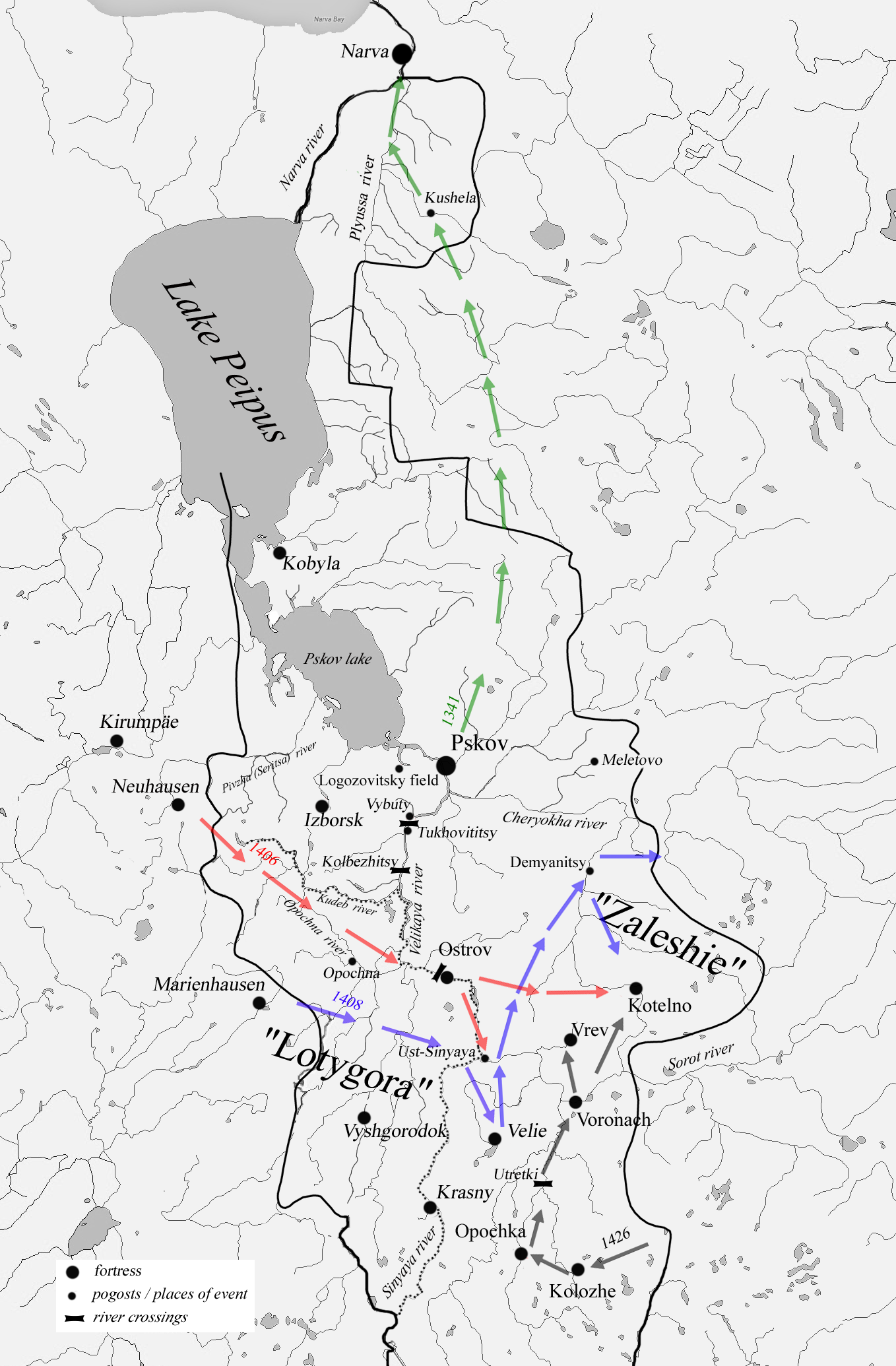
In 1341–43 there was a border conflict caused by the murder of Pskov ambassadors by the Livonians in the "village on Opochna" (Opochna river, left tributary of Vyada river.) and the building of the castle Neuhausen in the middle flow of the river Pimja (Piusa) by the Livonian side. The description of military operations of this period stands out from the general background of chronicle reports with an abundance of topographical details
The first mentioned in the course of military actions is the campaign of the Pskovites and Ostrovites on Lotygоra on the 5th of June, 1341, and the collision at the Prince's village Izgoi (on the right Bank of the Velikaya River) with the counter-invasion of Germans and Latgalians (Nasonov, 2000). The description of events suggests existence of a ford in the area of military operations. Most likely, it was a ford in the area of the rapids at the churchyard Kolbezhitsy between the mouths of the rivers Smolinka and Kudeb (Kudep) or just South of the mouth of the Kudeb. This place was located about halfway between Pskov and Ostrov, and was convenient for a coordinated meeting of Pskov and Ostrov detachments. If we take into account that the Kudeb and the Opochna, located to the South of it in the years 1247 and 1340, are mentioned as located in "Lotygora", it can be argued that the river Kudeb was the Northern border of the Livonian-controlled "Lotygora" (Probably the southern boundary of “Lotygora" was the river Sinyaya.) . In this case, an attempt to cross the Velikaya river in a place as close to the target of the invasion as possible seems logical.
The second clash of this period was the Pskov campaign led by the Posadnik Karp Kalika in Zanarovye in June 1341 (Nasonov, 2000). Here the mention the Kushela churchyard, located at a considerable distance from the coast of lake Peipus and the Narva river (about 33 km in a straight line) is important, as it correlates with the report that the campaign was made by "peshtsy" (on foot) and not by water. It can be assumed that the route of Karp Kalika ran not along the shore of the lake (along the highway of the latest Gdov road) but along the route Krivovitsy – Verkholino – Myslogostitsy, and further downstream the river Plyussa (Figure
If we assume that Karp Kalika detachment moved along the route traditional for that period, we can conclude that the main route of the road from Pskov to Narva in the 14th century lay at a considerable distance from the coast and went along the Pskov-Novgorod border to the ford located in the Narva rapids area (The route could coincide with the winter road, along which in 1268 and 1269 the Russian army moved from Dubrovno to Rakovor/Weisenberg (PSRL, vol. 6, 2000, p. 323-324). In any case, the chronicle information about “chudi” hiding in a cave can be correlated with the mid-19th century report about the "passage under the waterfall" on the Narva rapids (Sanktpetergurgskaya guberniya, 1851, p.104-105).) .
In mid-April, 1342, the Novgorod campaign to Neuhausen with the purpose to try to establish interaction between Pskov and Novgorod took place, but the Novgorod army was stopped by the Pskov Embassy one at Meletovo and returned to Novgorod (Nasonov, 2000). We can assume that it moved through Dubrovno, along the main Pskov-Novgorod road.
The route of the campaign of Olgerd and the Pskov people, begun on August 2, 1342, ran through the territory most explored in terms of studying transport land communications of Pskov land. The Pskov-Lithuanian vanguard passed through Izborsk and encountered the main Livonian forces on the Mekuzhitsa river and Mekuzhitsky field (in the area of modern Miikse/Mekuzhitsy) (Further Mekuzhitsy became crossroads, through which the way from Neuhausen to Izborsk and later to Pechory passes.) , from which it retreated to Izborsk. The movement of the main allied forces from the fords across the Velikaya to Kamno coincides with the route of the Livonians in August 1407, where the fords at Tukhovititsy (Tukhovik) are named as the starting point. The further route led to Izborsk. The capture of the village Halahalnya of a prisoner-informant led to the operation folding to clashes with the Livonians in the area for Gramsky swamp.
In 1347 Olgerd marches to Novgorod, ravages the land between the Shelon’, Luga and Mshaga rivers, and returns to Lithuania via Pskov territory (Nasonov, 2000). Since the first item mentioned in the Novgorod chronicle is the mouth of Mshaga (19 km from the river Shelon’ mouth) and the next is Golin (the main ford at the mouth of the Shelon’), we can assume that Olgerd did not come along the Shelon’ from Porkhov, but from the South, from Rusa).
After crossing the Shelon’ in Golin, he plundered the territory to the churchyard Sablya on the Luga river, then returned to the Shelon’ and took the ransom from Porkhov. From Porkhov, Olgerd moved “to himself (to Vitebsk?) through the Pskov volost”. (Nasonov, 2000, p. 26). It is more logical to assume that he did not move through Dubrovno, but used the road to Koshkin Gorodok, and then to Demyanitsy-Voronach.
Military operations were resumed in 1348 during the Novgorod-Swedish war for the Neva. During the Livonian RAID in the summer of 1348 (Nasonov, 2000), the Germans most likely crossed the river Velikaya in Ostrov, having ravaged its surroundings, and returned to the left Bank of the Velikaya via the Kolbezhitsky rapids or at Vybuty, which is even more likely. Then the Livonians moved in a wide front, presumably on both sides of the "Gramsky swamp". Fixation of the beginning of the raid in Ostrov once again confirms that the left bank of the Velikaya river, between the flows of Kudep and Sinuaya, was not controlled by the Pskov people during this period.
Military enterprises of Vytautas, Konrad von Fittinghoff and the Pskovites in the early 15th century are of no less interest for historical and topographical reconstructions.
The campaign of Lithuanians, which began on February 5, 1406, and the" chase" of the Pskov people, on February 28, are considered together because of their close relationship and the absence of a significant time gap. Vytautas invaded Kolozskaya volost, captured and destroyed Kolozhe, from where part of the Lithuanians (probably led by Vytautas himself) moved to Voronach in order to demoralize the Pskov people and delay a possible pursuit (Nasonov, 2003).
Pskov Posadnik Yuri Filippovich Kozachkovich with a small detachment began to pursue Lithuanians in the direction of Pustaya Rzheva and Luki (Velikiye Luki (The name "Velikiye" was applied to the city of Luki some time later.) ), where he defeated the Lithuanian rearguard, recapturing the "styag" (military banner) of Kolozhe. The location of the Kolozhsky trophy thus marks the direction of the main Lithuanian army departure: from Kolozhe to Pustaya Rzheva, Luki and further, most likely, to Usvyaty.
The main forces of von Vittinghof during the campaign of Livonians in August, 1406 crossed the Velikaya river and for some time besieged Ostrov (figure
On October, 7, 1406, the people of Pskov, in their turn, invaded Livonia. On the river Seritsa (The exact location of this river has been the subject of debate more than once. In 2019, one of the authors of this article suggested (partly in solidarity with the research of H. Valk (Valk, 2009, pp. 94-101)) that the Pskov people called the river Pivzha-Seritsa (after one of its South-Eastern tributaries that flowed through the territory of Izborskaya volost). The name Pivzha was applied only to its North-Western tributary. The river Seritsa is also mentioned in the description of the events of August 27, 1501.) a detachment of the Livonians, sent towards Pskov was surrounded and destroyed. Getting around Neuhausen (Novii Gorodok) from the North, the Pskovites headed straight to the castle Kiripegu (Kirumpäe). In 15 versts from the castle the Pskov army was met by the Livonians, probably moving forward (to intercept). The battle was won by the army of Pskov (Nasonov, 2003).
During the campaign "for Narova" (in Virland), started on June 22, 1407, the Pskov army reached Borholm (Porkuni). Chronicles of Moscow circle reported the capture city Jazvin (Javzin) (Probably, Wesenberg / Rakovor/Rakvere is hidden under this name. ) by Russian troops– the fact not recorded in Pskov Chronicles.
The unusual direction of the invasion allowed the Pskovites to ravage Virland in the absence of organized resistance from the Livonians. The remarkable mention of the fact that the Pskov troops "
The Livonian retaliatory campaign in August, 1407 started from Weissenstein (White Stone, Paida) (Nasonov, 2000) (A. N. Nasonov mistakenly believes that White Stone = Kamno (PSRL, 2000, pp. 336, 340).) . This time, the Livonian troops were not divided into independently operating detachments, and on August, 18, they attempted with all their strength to cross the Velikaya river, at Tukhovititsy. Their way was blocked by the Pskov army, which stood under the protection of field fortifications.
After a 4-day "standstill" and unsuccessful attempts to cross the river, on August, 21 von Fitinghoff began to withdraw his troops in the direction of the Pogost Kamno and Logozovitsky field (about 20 km Northwest of Tukhovititsy) to connect with the German flotilla moving at this time from Narva (Nasonov, 2000). After the battle, which the Pskov chronicler referred to as one of the three bloodiest battles in the history of Pskov, the Pskov people retreated to the city, and the Magister went to Livonia.
In this case, the place of the beginning of the Livonian campaign is of most interest. Its choice can be explained by the fact that during the Pskov invasion in Wyrland in Weissenstein, the Livonian troop concentration with the aim to prevent the Pskovites from attacking Revel or Derpt, could begin. Since the Pskov people turned off hostilities, the Magister decided to use the military forces at his disposal for a retaliary invasion. The question arises - did the Livonian army traditionally move through Neuhausen or, to shorten the route, turned from the castle of Kirumpäe to modern Pechory?
The Magister makes the campaign in February 1408, with the active support of the Lithuanian allies, and this leaves an imprint on the entire course of military operations (Figure
Having blocked Velie with a significant detachment, the Magister, presumably on the ice of the Sinyaya, the Velikaya and small right tributaries of the latter, came to the upper reaches of the Cheryokha river (Zales(sh)ie region), where he camped at the churchyard Demyanitsy. From Demyanetsy the invasion to Novgorodian lands, where there were ravaged Lezhenitsy, Bolota, Dubsk, Gosten’ and the surrounding of Koshkin town, was made (Nasonov, 2000). After an unsuccessful assault on Velie by the combined forces of the Lithuanians and Livonians and the defeat of one of the Lithuanian detachments at Voronach, the Magister left the Pskov lands.
During the campaign in February 1409, Dorpat was probably the initial gathering point for the invasion. Von Fittinghoff, thus, came along the ice of the Chudskoye lake, ruined Zapskovye (In this context, the toponym should be understood in a wider meaning as the land located to the West of the Pskova river (compare Zavelitskaya zasada as an administrative unit of the Pskov uyezd, which combined all the churchyards of the Northern part of the left bank of the Velikaya river).) , and Novgorodian churchyards of Zaplussye.
In general, the descriptions of the military actions of this period draw a very dynamic picture. All the campaigns of Konrad von Fittinghoff were made in different directions, two of them were summer (August), two – winter (February), in two cases the Novgorod lands were under attack. Pskovites' actions were no less creative. Both of their significant incursions into Livonia were made along the routes that were not traditional for Pskov raids.
Significant information about the ways of communication in Pskov land is provided by the description of the events of the Pskov-Lithuanian war in 1426 (Figure
Having rejected the peace offers of Pskov, Vytautas began preparations for storming the city. The Pskov people, convinced that Vytautas was not going to stop military operations, burned the Pskov posads (Nasonov, 2000), and – since it became impossible to use Voronach as a supporting fortress – sent a large detachment to strengthen the garrison of the fortress Kotelno repeatedly mentioned above. On hearing this, Vytautas moved to Kotelno, and the Pskov people, who came to the fortress, faced the main Lithuanian forces (Nasonov, 2000).
At the same time, the inhabitants of Ostrov, who were returning from Velie, defeated a small Tatar detachment from the Lithuanian army composition under Ostrov. The second group of Lithuanians was defeated under Vrev.
According to these data, it can be assumed that the main road connecting Pskov with Lithuania at this time, passed along Opochka –Voronach – Kotelno – Pskov highway, and only after Kotelno lost the significance of the administrative center of Zalesye, shifted to the West, to Ostrov. Lithuanians and Tartars came to Ostrov and Vrev, probably, along the local roads from Voronach.
Conclusion
So, in the course of the analysis of military actions that took place during the periods 1341–1348, 1406–1409, and the year 1426 in the Peipsi and the Velikaya river regions the routes of the main roads of the region were clarified:
On the basis of mapping the locations where the actions of predatory groups of both Livonians and Pskovites took place, it can be assumed that the section of the left bank of the Velikaya river between the Kudep and the Sinyaya rivers in the 14th – first half of the 15th cc. was controlled by Livonians (Cepkovym, 2009). The situation changed after the transfer of the main southern border fortress of Pskovites from Kolozha to Opochka (1414) (Nasonov, 2000).
From this time on, the Pskov people became able not only to control the section of the river between Ostrov and Opochka, but also to spread their influence up the river Sinyaya and its tributaries. It led to foundation of Krasny Gorodok in 1461 and in 1476 of Vyshgorodok on the river Lod’ and the eventual displacement of Livonians from the territory of Purnau. Probably in connection with the struggle for this region, Walter von Plettenberg planned to build a direct road from Marienburg in the direction of Pskov, hoping thus to overcome the advantage of Pskov in the expansion logistics (Hildebrandt, 1865).
By the beginning of the 15th century, there were two transit land routes from the Livonian border to Novgorod. In both cases, the route started from the Neuhausen castle and ran parallel to the river Cheryokha, but if the Northern version of the route (through Keb’, Zagorye, Meletovo and Dubrovno) is sufficiently known, the southern version (fords on the Velikaya river in Ostrov or Vybuty – Demyanitsy – Koshkin Gorodok) is taken into account by researchers much less often. The existence of the southern route is confirmed by the events of 1394, when Novgorodians, pursued by the Pskov people, retreated from Pskov in the direction of Vybuty (Nasonov, 2003), intending to use this road.
The Road to the Northern part of Pskov land and further to Narva passed at a considerable distance from the lake coast, and went through the pogost Kushela (modern village Kushela, Leningrad region).
The major (?) meridional route connecting Pskov and its South-Eastern suburbs passed through Kotelno, Voronach, Kolozhe (after the year 1410 through Opochka), and then continued in the direction of Rzheva Pustaya.
Less significant routes connected Velie with Voronach and Ostrov. The Velieskaya road most likely came to Ostrov through the Ostrovsky ford, and Velie and Voronach probably kept in touch through the ford at the pogost Utretka. Probably at this time there was already a direct road from Voronach to Ostrov.
In addition to the main road leading from Pskov to Livonia via Neuhausen, there was a less frequently used one that passed in the area of modern Pechory, and went to Kirumpäe bypassing Neuhausen.
Acknowledgments
The study was funded by the Russian Science Foundation, Project Number 19-18-00183.
References
- Braudel, F. (2002). Sredizemnoe More i sredizemnomorskij mir v epohu Filippa II [The Mediterranean and the Mediterranean world in the time of Philippe II]. Yazyki slavyanskoj kul'tury.
- Cepkovym, A. I. (Ed.) (2009). Henry of Latvia. Chronicle of Livonia. Aleksandriya.
- Hildebrandt, H. (1865). Bericht über die im Reval'schen Rathsarchiv für die russisch-livländischen Wechselbeziehungen im 15. und 16. Jahrhundert ausgeführten Untersuchungen [Report on the investigations carried out in Reval's Rathsarchiv for the Russian-Livonian interrelationships in the 15th and 16th centuries]. Mélanges Russes tirés du Bulletin historico-philologique de l'Académie des scienes [Russian excerpts are taken from the historical-philological bulletin of the Academy of Sciences], 4(530).
- Kharlashov, B. N. (1995). Pogosty i guby v Pskovskoj zemle XIV–XVI vv. [“Pogosts” and “gubas” (administrative units) in the Pskov land XIV–XVI vv.] (Doctoral dissertation). Institute of Archaeology of Russian Academy of Sciences.
- Mushketov, I. V. (2017). V predgor'yah Pamira i Tyan'-Shanya [In the foothills of the Pamir and Tien Shan]. "E".
- Nasonov, A. N. (Ed.) (2000). Polnoye sobranie russkih letopisey. Pskovskie letopisi. Tom 5. Vipusk 2 [The full collection of Russian annals. The chronicles of Pskov. Volume 5.Iissue 2]. Yazyki russkoj kul'tury.
- Nasonov, A. N. (Ed.) (2003). Polnoye sobranie russkih letopisey. Pskovskie letopisi. Tom 5. Vipusk 1 [The full collection of Russian annals. The chronicles of Pskov. Volume 5.Iissue 1]. Yazyki russkoj kul'tury.
- Salmin, S. A. (2019). Prestol'nye posvyashcheniya pogostskih cerkvej i dinamika rasprostraneniya klerikal'no-administrativnoj sistemy v Pskovskoj zemle v konce X–XV vv. [Patronal consecrations of pogost churches and the clerical-administrative system spread dynamics in the Pskov land at the end of the 10th–15th cc.]. Vestnik Universiteta Dmitriya Pozharskogo [Vestnik of the University named after Dmitry Pozharsky], 2(14), 10-35.
- Salmina, E. V., Salmin, S. A., & Matsevich, S. F. (2020). Military-Political History of the Pskov-Livonian Border: History of Struggle for Natural Resources in the Context of Climatic Changes of 14th–15th cc. In: Kolmykova T., Kharchenko E. (Eds.), Digital Future Economic Growth, Social Adaptation, and Technological Perspectives. Lecture Notes in Networks and Systems (829-840). Cham ZG: Springer.
- Sanktpetergurgskaya guberniya. (1851). Sanktpetergurgskaya guberniya. Voenno-statisticheskoe obozrenie Rossijskoj imperii. Tom 3. Chast 1 [Sanktpetergurg guberniya. Military statistical review of the Russian Empire. Volume 3. Part 1]. Saint Petersburg: Tipografiya Departamenta Generalnogo shtaba.
- Selin, A. A. (2017). Smuta na severo-zapade v nachale XVII veka: ocherki iz zhizni novgorodskogo obshchestva. [The Time of Troubles in the North-West in the early 17th century: sketches of Novgorod society life]. Saint Petersburg: Russko-Baltijskij informacionnyj centr "BLIC".
- SMAMU. (1913). Sbornik Moskovskogo Ministerstva Justisii. Tom 5. Pskov I ego prigorody [Collection of the Moscow archaive of the Ministry of Justice. Vol. 5. Pskov and its suburbs]. Moscow.
- Valk, H. (2009). Ob istorii osnovnyh putej iz Izborska na zapad.[About the history of the main routes from Izborsk to the West]. In E. V. Voronkova & S. A. SHein (Eds.), Izborsk i ego okruga. Materialy mezhdunarodnoj nauchno-prakticheskoj konferencii 2007-2008. [Izborsk and its neighbourhood. Materials of the international scientific and practical conference 2007-2008] (94-101). Izborsk: Gosudarstvennõi istoriko-arhitekturnõi i prirodno-landshaftnõi muzej-zapovednik "Izborsk".
Copyright information

This work is licensed under a Creative Commons Attribution-NonCommercial-NoDerivatives 4.0 International License.
About this article
Publication Date
27 May 2021
Article Doi
eBook ISBN
978-1-80296-107-2
Publisher
European Publisher
Volume
108
Print ISBN (optional)
-
Edition Number
1st Edition
Pages
1-1907
Subjects
Culture, communication, history, mediasphere, education, law
Cite this article as:
Salmin, S., Salmina, E., Bessudnova, M., & Matsevich, S. (2021). Communication Routes In Pskov-Livonian Borderland (14th – Early 15th Centuries). In E. V. Toropova, E. F. Zhukova, S. A. Malenko, T. L. Kaminskaya, N. V. Salonikov, V. I. Makarov, A. V. Batulina, M. V. Zvyaglova, O. A. Fikhtner, & A. M. Grinev (Eds.), Man, Society, Communication, vol 108. European Proceedings of Social and Behavioural Sciences (pp. 925-935). European Publisher. https://doi.org/10.15405/epsbs.2021.05.02.118