
Quantitative Assessment Methods For Integrated Water Resources Management


Abstract
Integrated water resources quality management is of particular importance for preserving the protected area since this is what determines the biodiversity of the aquatic and terrestrial biota and ensures the requirements and rights of citizens. This article is dedicated to international experience in the concept of integrated water resources management (IWRM) utilizing the methodologies for implementing specific complex environmental management aspects, based on the integral indicators of bio-communities health and quality management statistical methods. The research performed on one of the most significant waterways of the state-protected areas in subtropical South Russia's region. Environmental management elements, applied to some protected areas of the Republic of South Africa, could be utilized for the mastering of a consistent quality environment monitoring system and establish a comprehensive database designed for developing a set of measures for the natural resource conservation rehabilitation. As a promising instrument for the practical implementation of the IWRM principles, the multimetric biotic index (MMI) is proposed within this research. MMI is built up on the parameters that reflect the biodiversity and stability of biological communities, degree of water organism's tolerance to external influences, and toxicity of the aquatic environment. Application MMI in combination with the DMAIC quality management principles, aims to achieve stability of processes occurring in river biocenoses by reducing the impact of controlled anthropogenic factors and, as a result, consistently improving the watercourse's ecological situation and adjacent ecosystems.
Keywords: DMAIC methodologyintegral bio-indicatorsintegrated natural resource managementmacroinvertibratesSix Sigma methodologywater resources
Introduction
Integrated Natural Resource Management (INRM) refers to the management of such resources as land, water, soil, flora and fauna, emphasizing the impact of this management on life quality of both present and future generations. This approach is based on regulating an interaction between people and natural ecosystems.
The conceptual framework for Integrated Natural Resource Management (INRM) has evolved in recent years due to the convergence of research in various fields, such as sustainable land use, joint planning, integrated water catchment areas management and adaptive management. INRM is widely used and successfully applied in regional and community-based environmental management. It is not a management of the environment itself. Natural resource management aims to ensure the protection and preservation of ecosystem services for future generations of people, as well as to support the ecosystems' integrity by adopting ethical, economic, and natural variables. INRM determines the factors that are affected by conflicts arising between satisfying society’s requirements and protecting natural resources and assets. It is, therefore, linked to environmental protection, sustainability, and integrated landscape management (Severinsen & Peart, 2018).
Natural resource management issues are inherently complex. It involves such factors as the ecological and hydrological cycles, climate, geography, and biological communities’ development. All these aspects are dynamic and inter-related. A change in one component may lead to severe, sometimes irreversible impacts to whole community. In addition to the natural systems, natural resource management also involves participation of various stakeholders and their interests, policies, politics, geographical boundaries, economic implications (Weston & Goga, 2016).
The concept INRM is used in various forms and, in general, encompasses formal integration and cooperation among stakeholders and managing agencies.
A history of the approach
The first application of the concept in a formal regulation was conducted in the Canadian Frazer River Estuary Program during the 1980’s in Canada.
It was legislated for the first time in New Zealand and reflected in the Resource Management Act 1991. The concept of Integrated Resource Management is also prevalent in the RSA's Constitution 1996. In the RSA context, the governance is often unclear where responsibilities lie and where traditionally no one sphere of government, agency, institution, or group of individuals has sole jurisdictional responsibility, such that problem solving capacity is widely dispersed and few decision-makers can accomplish their mission alone (Shackleton et al., 2002).
INRM was further disseminated in international terms during the International Conference on Water and the Environment (ICWE) in Dublin, Ireland, on January 1992. The Dublin Statement on Water and Sustainable Development recognized the increase of water deficiency because of the different conflicting uses and water overuses. Currently the concept is implemented in the various legislative acts or parts of acts that govern environmental aspects of many countries, provinces, states, and districts.
Definition of Integrated Water Resources Management
One of the first IWRM meaningful definitions as a special management process, was issued in 2000 in the documents of the Global Water Partnership Technical Advisory Committee (2000):
Integral Water Resource Management is a process which promotes the coordinated development and management of water, land and related resources, in order to maximize the resultant economic and social welfare in an equitable manner without compromising the sustainability of vital ecosystems (p. 22).
This definition's innovation is seen in overcoming the sectoral, separate approach to the various natural resources’ management, which did not consider the relationship and mutual influence of water and terrestrial ecosystems.
Moreover, the United States Agency for International Development (USAID) describes IWRM as a process of coherent planning and implementation of actions based on scientific data, connecting the stakeholders to determine how to meet the long-term people’s requirements for water resources, while preserving environmental services and economic benefits (USAID WaterTeam, 2002). This definition contains the extremely important statement that the Integrated Water Resource Management (IWRM) is not just a plan of water resource management, but process, which utilizes a broad set of principles, tools and guidelines that should be adapted to the specific circumstances of each country, region or river basin.
Common in the projects
In this study, an example of practical implementation of the Integrated Natural Resource Management methodology elements in the protected areas of South Africa and the South of the Russian Federation (Sochi resort region) was presented, since both projects have common features:
Concept Integrated Resource Management is applied in combination with DMAIC quality management principles and statistical quantitative methods for processes improving, united within the "Six Sigma" approach umbrella.
In both cases, the IRM is considered for regions with intensive environmental tourism development in the specially protected areas.
Monitoring, conservation, and management of water resources is considered essential for both areas, as it affects the biodiversity of terrestrial flora and fauna and the region's attractiveness for visitation.
Significant parts of the territory around the Greater Sochi is included into the net of the unique natural protected areas, which embraces the Caucasian biosphere reserve, Sochi National Park, and other natural history landmarks of local, regional, and state significance. Such territories are the powerful factors of tourist attraction to the region. Therefore, the development of its economy is strongly dependent on the management and maintenance of the natural geo-biocenoses of the statutory protected areas.
Problem Statement
The main problems, which decrease the effectiveness of water preservation activities, conducted on the resort of Sochi, are seen in the absence of timely objective information about the "impact factors" on water quality such as chemical, physical and biological aspects, which often have an anthropogenic character and potentially can be controlled by natural resource consumers. Problems include water characteristics formed as a result of primary and secondary pollution; the watercourse ecosystem's state (Gulachieva et al., 2018), and, in the greatest extent, the absence of a methodology that allows specialists of the environmental authorities to conduct an operational analysis on the basis of these data sets and timely identify the causes that affect the water quality deterioration in the river allowing taking the necessary administrative measures and assess their effectiveness.
The proposed methodology of monitoring and rivers’ ecological state management, using integral bioindicators and quality control methods, is intended to resolve these problems.
Research Questions
How to apply the Integrated Natural Resource Management approach on the subtropical protected areas, utilizing complex biological assessment and Six Sigma principles and considering main stakeholders' interest in terms of the water recourses consumption needs?
Purpose of the Study
The purpose of this research is to master an integrated bioindicators system for assessing the state of hydro-resources and water bio-communities health in the territory with the intensive resort and recreational sector of the economy development, providing timely quantitative determination and analysis of the impact factors affecting and their route causes and allowing stabilization and optimization of the processes occurring in the natural watercourses;
Research Methods
In research, for resolving the stated above issues, an integral indicator of quality and stability of processes in aquatic biocenoses developed and tested by the authors during the previous studies was used (Gorbunova, 2019).
Integrative Multimetric Indicator
The assessment of biota is a widely recognized means of determining the river’s ecological condition. Benthic macroinvertibrates, in particular, are recognized as valuable organisms for bio-assessments, due largely to their visibility, ease of identification, rapid life cycle often based on the seasons and their largely sedentary habits. Numerous bio-assessment techniques have been developed over the last three decades, varying in complexity and region of implementation. For instance, South Africa has an exemplary history in this field, culminating in the refinement of invertebrate and other techniques and their application in a National River Health Programme. The method, which forms the backbone of this program, is a refinement of the highly successful SASS (South African Scoring System) method developed by Chutter in 1994. The spatial variability on a river's reach with similar water quality characteristics was found to be statistically negligible. The method is a consistent and repeatable river health assessment measure, considering all biotopes (Dickens & Graham, 2002).
The similar indicator, the multimetric index, (MMI) was mastered for water bodies assessment in the South of Russia areas with subtropical climate and the dynamic advancement of the recreational and resort economy sector. MMI is based on parameters reflecting biodiversity and stability of mountain type rivers' biological communities, the tolerance degree of their constituent water organisms to external influences and the aquatic environment toxicity for its inhabitants. Calculation of the MMI is conducted on the ground of qualitative and quantitative analysis of macroinvertebrates samples, what corresponds to the approach adopted for National River Health Programme in South Africa. Analysis of macroinvertibrates community biodiversity was conducted in accordance to the "Guidelines for hydrobiological analysis methods of surface waters and bottom sediments" developed by Abakumov in 1983.
During further studying the effectiveness of this method in the application to the environmental control and monitoring practices, other characteristics may be included in the MMI calculation system, considering the goals and conditions of work. The research was conducted during 2016-2019.
Six Sigma approach
In this study, MMI is used as a component of integrated water resource management, formed on the basis of the DMAIC quality management and statistical quantitative methods for process improvement, united within the "Six Sigma" methodology which includes consistent aquatic environment quality monitoring and its restoration by eliminating and / or minimizing the identified impact factors affecting natural watercourses facing anthropogenic pressure. In accordance to Six Sigma approach, the identified impact factors are accepted as process inputs and treated as controlled (such as volumes of discharged toxicants, nutrients and suspended solids, degree of deforestation of the river’s banks and etc.) and uncontrolled (such as climatic and geological changes) variables. According to the ISO “Quantitative methods in process improvement – Six Sigma – Part 1: DMAIC methodology”, the processes occurring in the waterway also can be improved by, for example, increasing the natural ability of the river’s waters to bio-filtering and self- purification, which is dependent on bio-communities species composition and ecological conditions for their development in the river (such as type of bottom substrate, degree of silting, oxygen regime and etc.). The proposed complex and continuous monitoring of the process will allow determination both clearly visible and hidden factors of influence, as well as an assessment of the natural processes functioning within the waterway.
The possibility of this approach application for systematic enhancement of the natural watercourses ecological situation was mastered and tested on the Mzymta River (Sochi, Krasnodarsky district, Russia).
Modelling instrument
In order to create a functional model that displays the structure and functions of the proposed system for monitoring and managing the river’s ecological condition, a graphical method implemented by the IDEF0 modeling methodology was used according to the Draft Federal Information Processing Standards Publication 183.
Findings
Application of the Integrated Natural Resource Management principles in the RSA’s protected areas.
Sanparks is a legal body in the South African Republic responsible for management of the national parks of the country (South African National Parks, 2016). Sanparks was created in 1926 and presently manages 21 parks, consisting of 3751,113 hectares which is over 3% of the total area of South Africa (ENCYCLOPÆDIA BRITANNICA, 2019).
The key characteristics of the Sanpark’s policy statement correspond to certain stages of the DMAIC methodology (SANParks, 2008):
(Define) The system definition: natural resources and assets which include all elements which are present within the Park's borders.
(Measure) Measure of key aspects of the resource and its positioning to the main parameters of the Park and all interested parties’ interests.
(Analyze) Analysis of the obtained data for verification of cause-and-effect relationships. The root cause of an undesirable result in the framework of scientific research is determined.
(Improve) Optimization of the current process based on data analysis using methods such as planning experiments and ongoing actions required to create a new, improved process.
(Control) The control of the processes that occur in the Parks is established, what guarantees that any deviations in the process are corrected before they lead to undesirable results. Management systems are being implemented, including statistical control and continuous monitoring of the process.
DMAIC methodology application for water resources management on the example of the Mzymta River in Sochi National Park (Russia).
The proposed methodology of rivers monitoring and ecological state management, using integral bioindicators and quality control methods, is intended to resolve stated above problems.
DMAIC methodology includes five stages: define, measure, analyze, improve and control. This study presents the methodology for performing the first two stages - "definition" and" measurement".
The first step of the "definition" stage involves identifying consumers and stakeholders, analyzing their needs, and presenting these needs as measurable requirements, and setting improvement goals.
The main expected result of the "monitoring and management of the ecological state of the river" process is the optimal water condition in the watercourse, which will satisfy majority of the stakeholders: the population that makes use of the river as a source of drinking water, for irrigation in a subsidiary economy, for recreation and resort users as well as agricultural and industrial enterprises that consume the river's water in their production processes (Chevallier, 2016).
To satisfy the requirements of distinct categories of freshwater consumers, following "Sanitary rules and norms of surface water protection from pollution», two categories of water were identified: potable and cultural-domestic purposes and fishery purpose. Regulations for the corresponding indicators are presented in the state Standard 17.1.04-77 “Nature protection. Hydrosphere. Indicators of the condition and rules of fishery water bodies’ taxation”, as well as in the Water Quality Standards of fisheries significance water bodies.
The stakeholders are identified, in accordance to ISO standard 37101:2016, as the person/s or organization/s that can affect, be affected by, or perceive itself to be affected by a decision or activity formed in a process of monitoring and rivers ecological state management. Consequently, the term "stakeholders", in addition to direct water users, includes local settlements, self-governments, located in the river's catchment area, other owners of the water body or its parts, controlling state authorities that together form the basis of territorial environmental management at the municipal level, as well as enterprises and individuals that do not use the water of this natural watercourse, but produce an impact on its condition (primarily – sources of pollution).
The stability of hydro-biocenoses and their biodiversity in the watercourse are considered as a key factor for the functional characteristics of the natural reservoir. It is, therefore, the tactical objective of the DMAIC methodology application for the studied aspect, which was determined as achieving stability of processes occurring in river biological communities by reducing the impact from regulated anthropogenic factors. The strategic objective is to consistently improve the ecological situation of the watercourse, due to the fact that the environmental characteristics of the object will become optimal to ensure conditions, which in turn will support the natural balance of the entire biocenoses variety, their self-restoration and recreational potential of the water body.
The next step in the "definition" stage is to describe the activity or process. In order to determine the factors, which provide most significant influence to the water environment quality, the Ishikawa's "root cause analysis" diagram was constructed (Figure
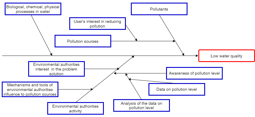
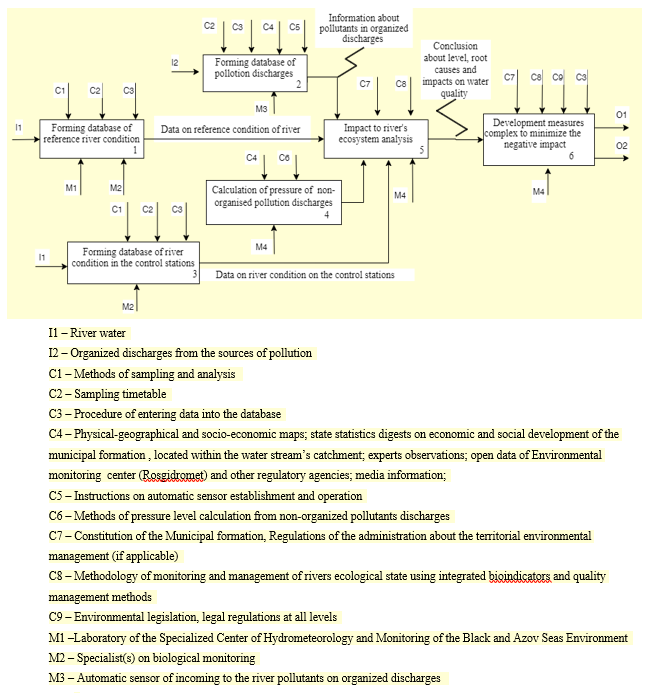
The graphical description of the studied process constructed utilizing the IDEF0 functional modeling methodology. This technology describes a system as a variety of hierarchically embedded actions or functions represented by a graphical block (a rectangle containing a name and number) with input (material or information that is used and converted by the process to achieve the result), output (material or information that represents the process results), control (management, limitation, and regulatory data that guide the process) and mechanisms (resources that perform the process).
Any block can be decomposed into its components to the required level of detail (Figure
The second stage of the DMAIC process improvement method is “measurement”, with the following goals: a) visual representation of data; b) determination of the basic efficiency of the current process to specify the project goals.
The first step is based on measurable indicators of river’s water quality, one or more critical variables which are selected for improvement. The further step is to determine the data that was collected to characterize the processes occurring in the watercourse and identify factors that affect its variability.
Identification and analysis of potential pollution sources and anthropogenic and natural impact factors was carried out on the basis of data collected from regional and municipal environmental control organizations, archived physical, geographical and socio-economic information, published analytical materials of state statistics on the economic and social development of municipal subdivisions, located in the watercourse basin, data from scientific research and expert observations, as well as information provided by the laboratory of hydro-meteorological environmental monitoring center. In addition, our own research data regarding the water body characteristics, including sampling and explorations throughout the entire watercourse, were used. On grounds of the obtained material, the river was zoned and homogeneous by essential criteria zones were identified based on the initial survey (Gorbunova, 2019).
As a result of the research, four main zones were identified along the river, which differ in their physical, chemical, and biological characteristics. It is important to note that the highlighted areas along the river also varied in the type of land use within their drainage area (Scherbina et al., 2018). Numerous researchers, who worked on the integrated bioindicators of the watercourse’ condition system development, reflected significant influence of this factor on the dynamics of river ecosystems (Deborde et al., 2016).
At the next stage, control maps were used to determine the trend of watercourse pollution dynamics in each identified zone of the river. For instance, the site located on the state protected territory is characterized by a stable composition and functioning of its hydro-biocenoses. There was no tendency to change in the dynamics observed, except for the usual seasonal fluctuations. At the same time, there are significant deviations of analyzed parameters detected within the river sections located in the anthropogenic impact zones. In further studies using the Six Sigma methodology application in the environmental management practice, such values can be considered as "defects".
In this case, when the Six Sigma methodology is applied to the processes occurring in a natural reservoir, improvement, in our opinion, should be understood as improving the quality of the water environment within the identified problem areas and returning the values of indicator parameters to the initial level (comparison with the background site). This is achieved by reducing the influence on the reservoir and development of its biological communities the main impact factors, which predominantly are of an anthropogenic origin. During this stage, with participation of all stakeholders, a plan to apply measures to target pollutant discharge reduction into the reservoir and/or decreasing the number of pollution sources in the river's catchment area should be developed.
In accordance with the Six Sigma methodology, the polluting enterprises’ technological schemes, including treatment facilities, providing the most efficient process to reduce waste generation or plan of further processing of waste, including waste water, into a commercially demanded product, must be considered primarily toward project implementation.
Thus, at this stage, the calculation of unsatisfactory process (defects) cost can be applied for all rivers’ water resource users identified at the earlier stages and entered in the database system. This scheme will be addressed and tested extensively at the next stage of the study.
Furthermore, for the optimization of natural processes in the watercourse, it is expedient to not only consider reducing the pollutants amount entering from any anthropogenic activity, but also the development of science-based methodologies aimed at restoring the natural river and its estuary zone of the Black Sea's self-purification potential. These approaches should be based on a comprehensive ecosystem analysis in the Mzymta river catchment area and include factors such as the type of bank vegetation cover, the degree of riverbed regulation and accumulation of solid runoff / siltation of the bottom substrate, the types of biocenoses surrounding the watercourse and their trophic chains, as well as the impact of river's drain on coastal marine biocenoses (Podgorny, 2017).
The improvement stage includes the implementation of previously developed approaches to optimize the water environment quality and restore its natural species composition, such as purification, recycle and reuse of wastewater and storm water, management of municipal and industrial waste, planning and control of water disposal and environmental management in the river catchment area, as well as the other measures. All approaches tested in the study area and implemented in practice should be documented in the database, as well as values derived from subsequent analytical control of the water quality indicators dynamics.
At the stage of control, the process, improved in the previous stages, is performed by creating a standardized system aimed at sustainable functioning and continuous improvement directed to maintain the required characteristics of the watercourse quality for a prolonged period of time.
Stability and sustainability of the hydro-biocenoses, as it was determined, apart from the natural factors (seasonality, water availability, etc.), are affected by variability in anthropogenic impact factors defined above. Taking into account that they are the most significant root causes of destabilization of the natural bio-communities structure and processes and the occurrence of long-term exposure effects, the control mechanism should be implemented, firstly, in mastering the standardized system of interaction between resources users and regulatory authorities in a timely fashion and, secondly, maintaining accessible information about polluting discharges and actions aimed at eliminating / reducing the destabilizing impact (for example, the immediate cessation of toxic or eutrophicated discharge into a reservoir).
Conclusion
Taking into consideration the complexity of resource consuming aspects, especially in the protected territories, a system of natural resources integrated management, per the regional characteristics, as well as interest and interaction among the stakeholders, is desired. Integration is conscripted to provide a synthesis in environment protection and ecology decision-making between various aspects of studying, preserving and improving the quality of the natural environment, the requirements of the law and environmental standards, and the interests of the population.
The stability of the reservoirs and adjacent territories' biological communities is one of the most important ecosystem indicators of the studied region. Therefore, utilizing of the DMAIC methodology in combination with methods that assess the charactercritical the river's geo-biocenoses provides control over the stability of processes occurring in the river communities by reducing the impact of controlled anthropogenic factors. Thereby, the solution can be provided to set strategic objectives such as consistent optimization of the watercourse ecological situation, which supports the natural balance of all to set biodiversity, self-regeneration, and recreational potential of the water body.
The proposed approach's innovation lies in the transition from sectoral assessment and decision-making in the environmental administration field to an integrated environmental management system of environmental regulation of various natural resources, including the water and terrestrial systems relationship and interaction, as well as various factors affecting their functioning.
The proposed method, following the principles of Integrated Water Resources Management, allows obtaining prompt information about the environmental characteristics of a watercourse and diagnosing the causes and sources of changes in river ecosystems.
Therefore, according to the authors, the developed system can be recommended for the process of information support and making effective management decisions in the field of hydro-resources protection and environmental planning and development of the territory.
Acknowledgments
The reported research was funded within the framework of the state assignment "Enhancement the mechanism of environmental management aiming to provide environmental and economic security of the tourism industry" (№ 0012-2019-0001) of the Russian Academy of Sciences.
References
- Chevallier, R. (2016). The State Of Community-Based Natural Resource Management In Southern Africa: Assessing Progress And Looking Ahead. The South African Institute of International Affairs (SAIIA) Occasional Paper 240. Johannesburg: University of the Witwatersrand. https://saiia.org.za/research/the-state-of-community-based-natural-resource-management-in-southern-africa-assessing-progress-and-looking-ahead
- Deborde, D. D., Hernandez, M. B., & Magbanua, F. S. (2016). Benthic macroinvertebrate community as an indicator of stream health: the effects of land use on stream benthic macroinvertebrates. Science Diliman, 28(2), 5-26.
- Dickens, C., & Graham, P. M. (2002). The South African Scoring System (SASS) Version 5: Rapid Bioassessment Method for Rivers. African Journal of Aquatic Science - AFR J AQUAT SCI, 27, 1-10.
- ENCYCLOPÆDIA BRITANNICA (2019). Retrieved 30/09/2020 from https://www.britannica.com/place/Kruger-National-Park,
- Global Water Partnership Technical Advisory Committee (TAC). (2000). Integrated Water Resources Management. TAC Background Papers No4. Stockholm: Global Water Partnership.
- Gorbunova, T. L. (2019). Razrabotka i aprobatsiya mul'timetricheskogo bioticheskogo indeksa dlya otsenki ekologicheskogo sostoyaniya rek na territorii Bol'shogo Sochi Developing and testing of Multi-Metrics Biotic Index for the river ecological status assessment on the Greater Sochi territory. Monitoring systems of environment, 3(37), 51–59.
- Gulachieva, S. V., Sokolov, A. A., Sokolova, O. A., & Makhosheva, S. A. (2018). System of assessment of regional mountain territories economic complexes sustainable development. Sustainable Development of Mountain Territories, 3(37), 329-335.
- Podgorny, K. A. (2017). Trebovaniya i podkhody k razrabotke biologicheskikh indikatorov i provedeniyu integrirovannogo analiza sostoyaniya vodnykh ekosistem: obzor [Requirements and approaches to the development of biological indicators and the conduct of integrated analysis of the state of aquatic ecosystems: review]. Works Of AtlantNIRO. New series, 4(1), 5-45.
- SANParks. (2008). Kruger National Park management plan. Pretoria: SANParks. https://www.sanparks.org/assets/docs/conservation/park_man/knp-management-plan1.pdf
- Scherbina, V. G., Gudkova, N. K., Gorbunova, T. L., Belyuchenko, I. S., & Agarkov, Yu. V. (2018). Primeneniye sistemnogo podkhoda pri bioindikatsionnom zonirovanii territorii po urovnyu ekologicheskogo riska [Systematic approach application for bio-indicative zoning of the area according to its level of ecological risk]. The North Caucasus Ecological Herald, V. 14, 1, 24-37.
- Severinsen, G., & Peart, R. (2018). Reform of the Resource Management System: The Next Generation – Synthesis Report. West Auckland: Environmental Defence Society Incorporated. https://www.eds.org.nz/assets/Publications/RMLR%20Synthesis%20Report_LO-RES.pdf
- Shackleton, S., Campbell, B., Wollenberg, E., & Edmunds, D. (2002). Devolution and community-based natural resource management: creating space for local people to participate and benefit? Natural Resource Perspectives, 7, 1-6. http://dlc.dlib.indiana.edu/dlc/bitstream/handle/10535/3646/76-devolution-community-based-natural-resource-management.pdf
- South African National Parks. (2016). SANParks Annual Report 2015/16. https://www.sanparks.org/assets/docs/general/annual-report-2016.pdf
- USAID WaterTeam. (2002). Integrated Water Resources Management. A framework for action in freshwater and coastal systems. https://webarchive.library.unt.edu/eot2008/20090825163059/http://www.usaid.gov/our_work/environment/water/
- Weston, D., & Goga, S. (2016). Natural resource Governance systems in South Africa: final knowledge dissemination report. WRC report, 2161/1/16. http://www.wrc.org.za/wp-content/uploads/mdocs/2161-1-17.pdf
Copyright information

This work is licensed under a Creative Commons Attribution-NonCommercial-NoDerivatives 4.0 International License.
About this article
Publication Date
16 April 2021
Article Doi
eBook ISBN
978-1-80296-104-1
Publisher
European Publisher
Volume
105
Print ISBN (optional)
-
Edition Number
1st Edition
Pages
1-1250
Subjects
Sustainable Development, Socio-Economic Systems, Competitiveness, Economy of Region, Human Development
Cite this article as:
Gorbunova, T., Matova, N., Annandale, J. M., & Du Toit, J. S. (2021). Quantitative Assessment Methods For Integrated Water Resources Management. In E. Popov, V. Barkhatov, V. D. Pham, & D. Pletnev (Eds.), Competitiveness and the Development of Socio-Economic Systems, vol 105. European Proceedings of Social and Behavioural Sciences (pp. 486-497). European Publisher. https://doi.org/10.15405/epsbs.2021.04.53