
Monuments Of Nature As A Part Of Socio-Ecologo-Economic System


Abstract
The article considers the nature monuments of republican significance, the Okhlebininsky gypsum cave and the Bolshoi Kolpak rock, located in the Iglinsky district of the Republic of Bashkortostan, as a socio-ecological-economic system. This involves the determination of environmental requirements and conditions for the development of recreation. Environmental requirements include nature conservation. In addition, to prevent adverse anthropogenic impacts on nature monuments on the adjacent land and water objects, protection zones are created. If the regimes of protection of nature monuments are established and declared for a long time, then for security zones this task is relevant. Determining the boundaries of protected areas on the ground requires consideration of many territorial factors. In determining the protected areas of the studied nature monuments, the boundary of the objects was taken into account, according to the state cadastral registration, relief conditions (slope steepness, difficult passage), the configuration of the river and its water protection zone, the state of nature monuments. In order to prevent and normal functioning, it is necessary to install information and warning stands along the access roads to the Bolshoi Kolpak rock and to the Okhlebininsky gypsum cave. Determining the conditions for recreation involves the compilation of determinants of the development of eco-tourist routes for nature monuments.
Keywords: Protection regimerecreationwater protection zone
Introduction
The Republic of Bashkortostan has significant landscape and biological diversity due to its geographical position - at the junction of several natural zones. Therefore, one of the priority areas of environmental protection is the development of a network of specially protected natural areas (hereinafter - SPNA) as a guarantor of the preservation of unique biological and landscape diversity, populations of rare plant and animal species (Stateprogram "Ecology and Natural Resources of the Republic of Bashkortostan", 2014).
Today the total area of SPNA of the Republic of Bashkortostan is 959.4 thousand hectares, or 6.7% of the entire territory. Among them, there are 218 SPNA: 3 state natural reserves (“Bashkirsky”, “Shulgan-tash”, “Yuzhno-Uralsky”), national park “Bashkiria”, 4 natural parks (“Aslykul”, “Kandry-Kul”, “ Muradymovskoe Ushelie”, “Iremel”) (Peter & Serova, 2018; Serova, Rakhmatullin, & Peter, 2017), 27 state natural reserves (including zoological - 17, landscape - 3, botanical - 7), 182 natural monuments and botanical garden. Each category has its own status, security mode and structure (Peter & Serova, 2018, p. 56).
The most numerous is the category of natural monuments. According to federal legislation, natural monuments are unique, irreplaceable, valuable in ecological, scientific, cultural and aesthetic relations natural complexes and their components, as well as objects of natural and artificial origin that need special protection. In the Republic of Bashkortostan, they are located on an area of 42.3 thousand hectares, which is 4.4% of the total area of all specially protected natural territories. Among them are geological, hydrological, geomorphological, botanical, zoological, as well as complex nature monuments, which preserve nests of rare birds, trout habitats, habitats of rare and valuable plant species, caves and waterfalls, geological outcrops, rocks, and individual mountain peaks (Rakhmatullina, Rakhmatullin, & Kulagin, 2018).
To prevent adverse anthropogenic impacts on nature monuments on the adjacent land and water objects, protective zones are created. By the Resolution of the Council of Ministers of the Bashkir ASSR (dated August 17, 1965, No. 465) “On the Protection of Natural Monuments of the Bashkir Autonomous Soviet Socialist Republic,” it was the responsibility of the executive authorities to determine the exact boundaries of natural monuments. At the end of the 2000s, the Resolution of the Cabinet of Ministers of the Republic of Bashkortostan (dated February 26, 1999 No. 48) was issued, which spelled out the need to create protected areas of natural monuments with a regulated regime of economic activity. A similar Decree at the federal level appeared in February 2015 (No. 138 of February 19, 2015) Law of the Republic of Bashkortostan…, 2015) requiring the establishment of protected areas, the establishment of their boundaries, the definition of the protection regime and the use of land for all categories of protected areas, regardless of their status. It was also stated here that land plots that are included in the boundaries of the protection zone are not withdrawn from their owners, but are used by them in compliance with the special legal regime. Within the boundaries of protected areas, activities that have a negative impact on the natural complexes of natural monuments are prohibited. The boundaries of protected areas are marked on the ground by special warning notices and information signs. Information about the borders with exact coordinates are entered into the Unified State Register of Real Estate (Decree of the Government of the Russian Federation dated February 19, 2015 No. 138) (Law of the Republic of Bashkortostan…, 2015). Since all objects are geographically located in different economic entities, with various forms of ownership, knowledge of the exact boundaries allows to reduce various controversial issues of land use.
In addition to environmental functions on the territory of natural monuments, it is possible to create conditions for the development of recreation. This network can serve as a support for conducting scientific research in the field of natural sciences, implementing environmental education programs, and developing ecological tourism as one of the economic sectors of the region.
Problem Statement
Consideration of nature monuments as part of the socio-ecological-economic system involves the definition of environmental requirements and conditions for the development of recreation. Environmental requirements include the protection regime of both the nature monument and its protection zone. If the regimes of protection of nature monuments are established and declared for a long time, then for security zones this task is relevant. In addition, there is no legal basis for defining the boundaries of protected areas of natural monuments.
Determining the boundaries of protected areas on the ground requires consideration of many territorial factors. These factors include the climatic conditions and the socio-economic development of the constituent entity of the Russian Federation, in whose territory the creation of a protection zone is planned; land category and type of permitted use, location of economic objects, deposits and occurrences of mineral resources, configuration of water objects, state of nature monuments and much more. Therefore, the determination of the boundaries of protected areas of natural monuments and the protection regime is made separately for each object and requires a large amount of research.
Establishing the conditions for recreation involves the compilation of determinants of the development of eco-tourist routes for nature monuments.
Research Questions
The subjects of the study was the nature monuments of republican significance of the Okhlebininsky gypsum cave and the Bolshoi Kolpak rock located in the Iglinsky district (Republic of Bashkortostan). Geographically, both monuments belong to the Iglinsky forestry service of the Ministry of Forestry of the Republic of Bashkortostan.
Okhlebininsky gypsum cave, an area of 5 hectares, belongs to the category of geological (geomorphological) nature monument. Location of the cave: 3.5 km south-east of the village Okhlebinino on a steep slope of the right bank of the river Belaya at 0.8 km below the mouth of the river Sim. Characteristic of the object: an entrance 14 m wide and 4 m high is located at the bottom of a karst dip with a diameter of about 50 m and 12 m located on the steep slope of the right bank of the r. Belaya 1 km below the mouth of the river Sim. Protection mode: visiting the cave with the use of open fire, cluttering the cave, chipping and removal of samples, gypsum mining, geological exploration (blasting, etc.), any construction are prohibited.
The Bolshoi Kolpak rock, with an area of 6.3 hectares, is located 1.5 km north-west of the village Okhlebinino. The Bolshaya Kolpak is a picturesque cliff 120 m high, breaking into the river Belaya along its right bank (Kachmarek, Vlodarchik, & Stasyak, 2012, p. 46). The rock is composed of gypsum and anhydrite with layers of dolomite. Mixed broad-leaved forests and small areas of steppe meadows with feather-like feather grass (Stipa pennata L.) are spread over the rock. Protection mode: due to the peculiarities of the natural complex, the harvesting of wood, the extraction of building materials, all construction, and blasting are prohibited on the territory of the natural monument.
Purpose of the Study
Objective: to ensure the socio-ecological and economic development of nature monuments of republican significance (the Okhlebininsky gypsum cave and the Bolshoi Kolpak rock) located in the Iglinsky district of the Republic of Bashkortostan to prevent adverse anthropogenic impacts on nature monuments on the adjacent land plots.
Tasks:
1. Compilation and analysis of comprehensive data on the need to create a protection zone based on natural landscape features and possible activities related to the implementation of environmental management on the territory adjacent to the nature monument;
2. Determination of the boundaries of protected areas of the above-mentioned nature monuments in real natural conditions, description of the current state, mode of protection and status;
3. Preparation of a map with the coordinates of characteristic points of the boundaries of the protected zone of a natural monument based on the data of a comprehensive field survey of the object, the provisions on the protected zone, the regime of the protected zone, drawing up a report of the territory survey;
4. Justification of the development of scientific and ecological tourism at nature monuments.
Research Methods
The study was conducted by analyzing the available information and processing stock materials with direct departure (field studies) on the objects to analyze the current state of these natural monuments and determine the protection zone. The parameters were fixed (geographic coordinates, altitude above sea level) using the navigator - Garmin GPSMAP-64.
All received materials were processed in a software QGIS (Quantum GIS) ver.3.2.1. (https://qgis.org/ru/site/). As a substrate, the Google Satellite image is used, which is loaded using the QuickMapServices module (http://nextgis.ru/blog/quickmapservices/). The area, the perimeter of the objects, and the coordinates of the points of the security zones were determined using the Add Geometry Attributes tool, using the setting — calculation on an ellipsoid. The construction of water protection zones was carried out using the Buffer tool. All coordinates are given in the World Geodetic System 1984 (WGS 84) coordinate system in decimal degrees (Rakhmatullina et al., 2018). The coordinates given in the Resolutions of the Government of the Republic of Bashkortostan No. 162 (2018) and No. 163 (2018) recorded in the Pulkovo projection (1942) were transferred to the WGS 84 system (Rakhmatullina et al., 2018, p. 59).
Findings
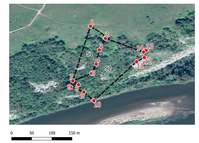
Inventory (route walk) of the object by points was carried out taking into account the natural features (vegetation) and relief (Figure
When approaching a country road from the north of the cave (point number 1, height 188 m), the path leads to the cave, which leads directly to the descent to the cave entrance, goes down along the bottom of the ravine. The entrance to the cave (point No. 6) is located at an absolute height of 108 m. Further down is the path to the river Belaya (Figure
Figure
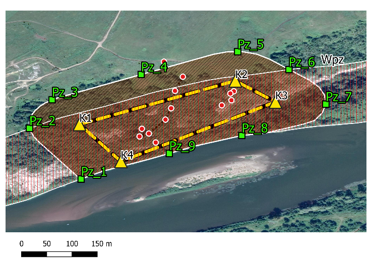
The security zone for the Okhlebininsky cave is taken with a reserve. When it was established, first of all, the boundary of the object was taken into account according to official data. The proposed protection zone is shown by the areal conventional symbol in the form of a brown shading. We consider it expedient to hold the cave guard zone from its border at a distance of 100 meters, but not along the entire border of the object. It can be seen that in the southwestern part, in the zone of Pz_1 and Pz_9 points, the protection zone is limited by the river’s coastline. The coordinates of the water protection zone of the river Belaya correspond to points Pz_2 and Pz_6 of the protected zone of the object.
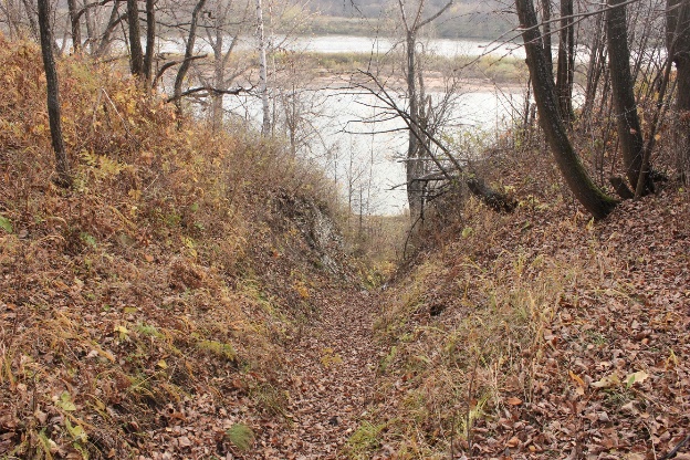
Intensive trampling down by visitors to the cave is the territory through which they descend to the cave (see Figure
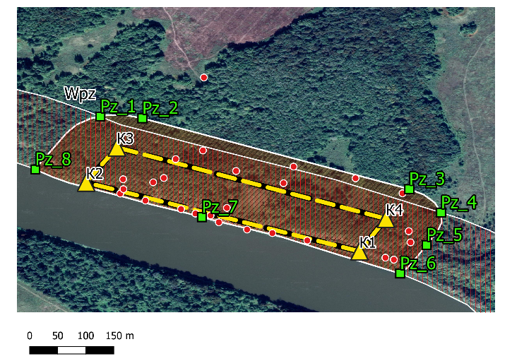
Similar work on the establishment of the ball protection zone was carried out with regard to the nature monument of republican significance “Bolshoi Kolpak rock” (Figure
The natural boundary - difficult for visitors, tourists - from the base of the cliff at the bank of the river Belaya to the east is a ravine that goes steeply upwards. From the edge of the river Belaya bank to the base of the Bolshoi Kolpak cliff, a water protection zone begins up the slope. Thus, the border of the Bolshoi Kolpak cliff, as an object of protected areas, falls under the water protection zone of the river Belaya (State program "Ecology and Natural Resources of the Republic of Bashkortostan", 2014) 200 meters wide. East ravine beam goes to the top platform of the rock. The security zone for the cliff is marked with a 100-meter strip along the perimeter of the object, with the exception of the southern part (points Pz_6, _7, _8), where the security zone runs along the coastline of the river Belaya. The total area of the Bolshoi Kolpak cliff with a security zone is 16.4 hectares.
Participation in the environmental education route involves visiting the specially protected natural areas of the Iglinsky district of Bashkortostan. During the developed route, tourists will get acquainted with the natural landscapes of the area, unique natural objects, will visit the Holy Trinity Church, take part in environmental campaigns, in arranging the territory of the natural monument. The route has an environmental focus. The choice of the area, the timing of the route depends on the climatic, landscape features of the area, transport accessibility, and the safety of participants.
Criteria: transport accessibility; the presence of unique natural objects; close proximity to each other; opportunity to demonstrate the impact of economic activity on the state of natural objects. Collecting information about unique natural and cultural sites is necessary for the formation of an ecological path. Having completed work on the study of objects of the area, the route was determined: Ufa - with. Okhlebinino - Okhlebininsky plaster cave (nature monument of the Republic of Belarus) - Bolshoi Kolpak rock - the city of Ufa. Approval of the route, ballroom assessment, development of a map of the tourist potential of the area are planned for the summer season. Let us see Table
Conclusion
1. Security zones for considered nature monuments are taken with stock. When they were established, first of all, the boundary of objects was taken into account according to the state cadastral registration, relief conditions (slope steepness, impassability), vegetation, the presence of a river and its water protection zone.
2. Intensive trampling down by visitors of the Ohlebininskaya gypsum cave is the territory through which they descend to the cave, and on the Bolshoi Kolpak rock - approaches from above to the rock itself. The main recreational load on the object, most likely, falls on the summer season.
3. Intensive housing construction in the adjacent territories of the million-plus city of Ufa and an increase in the mobility of the population increases the recreational load on the natural objects located in these territories. In order to prevent and normal functioning, it is necessary to install information and warning stands along the access roads to the Bolshoi Kolpak rock and the Ohlebininskaya gypsum cave.
4. The proximity of the Okhlebininskaya gypsum cave, the Bolshoi and Malyi Kolpak rocks, the right slope of the river Belaya in the Iglinsky district of the Republic of Bashkortostan is a favorable factor for conducting scientific research in the natural sciences. Implementation of environmental education programs, the development of ecological tourism as one of the economic sectors of the region.
References
- Gosudarstvennaya programma «Ekologiya i prirodnyye resursy Respubliki Bashkortostan» [State program "Ecology and Natural Resources of the Republic of Bashkortostan"]. (2014, February 18). Retrieved from: https://economy.bashkortostan.ru/dejatelnost/strategicheskoe-planirovanie/programmno-tselevoe-planirovanie/gosudarstvennye-programmy-respubliki-bashkortostan/files/%D1%8D%D0%BA%D0%BE%D0%BB%D0%BE%D0%B3%D0%B8%D1%8F.pdf
- Gosudarstvennyy doklad o sostoyanii prirodnykh resursov i okruzhayushchey sredy Respubliki Bashkortostan v 2017 godu [State report on the state of natural resources and the environment of the Republic of Bashkortostan in 2017]. (2018, September 6). Retrieved from: https://ecology.bashkortostan.ru/presscenter/lectures/488/
- Kachmarek, Y. A., Vlodarchik, B., & Stasyak, A. (2012). Turisticheskiy produkt [Travel product]. Moscow: Yuniti-Dana.
- Peter, Ye. V., & Serova, O. V. (2018) Landshaftno-ekologicheskaya otsenka territorii oz. Aslykul' Respubliki Bashkortostan: Sovremennyye landshchaftno-ekologicheskoye sostoyaniye i problemy optimizatsii prirodnoy sredy regionov [Landscapeandenvironmentalassessmentofthelake. Aslykul of the Republic of Bashkortostan: Modern landscape-ecological state and problems of optimization of the natural environment of the regions]. Moscow: Izdatel'stvo Istoki.
- Rakhmatullina, I. R., Rakhmatullin, Z. Z., & Kulagin, A. A. (2018).Ekologicheskoye kartografirovaniye: praktikum [Environmentalmapping: alaboratory manual]. Ufa: Izd-vo BGPU.
- Serova, O. V., Rakhmatullina, I. R., & Peter, Ye. V. (2017). Rekreacionnaya harakteristika poberezh'ya ozera Aslykul'[Recreational characteristics of the coast of Lake Aslykul]. Izvestiya Ufimskogo nauchnogo tsentra Rossiyskoy akademii nauk, 4(1), 13-17.
- Zakon Respubliki Bashkortostan «Ob osobo okhranyayemykh territoriyakh v Respublike Bashkortostan» 31.07.1995 №5-z [Law of the Republic of Bashkortostan “On Specially Protected Areas in the Republic of Bashkortostan” 07/31/1995 No. 5-z]. (2015, April 28). Retrieved from: http://base.garant.ru/17707110/
Copyright information

This work is licensed under a Creative Commons Attribution-NonCommercial-NoDerivatives 4.0 International License.
About this article
Publication Date
15 November 2020
Article Doi
eBook ISBN
978-1-80296-092-1
Publisher
European Publisher
Volume
93
Print ISBN (optional)
-
Edition Number
1st Edition
Pages
1-1195
Subjects
Teacher, teacher training, teaching skills, teaching techniques, special education, children with special needs, computer-aided learning (CAL)
Cite this article as:
Iskhakov, F., Rakhmatullina, I., Serova, O., & Gatin, I. (2020). Monuments Of Nature As A Part Of Socio-Ecologo-Economic System. In I. Murzina (Ed.), Humanistic Practice in Education in a Postmodern Age, vol 93. European Proceedings of Social and Behavioural Sciences (pp. 493-500). European Publisher. https://doi.org/10.15405/epsbs.2020.11.51