
Geoinformation Monitoring Possibilities In Ensuring Sustainable Development Of Regions

Abstract
A modern understanding of the sustainable development of territories implies maintaining such a balance of dynamic processes of the complex interaction between natural and anthropogenic systems that would allow preserving natural wealth as the basis for socio-economic regional development. In regard to this, monitoring of land conditions is a key element for ensuring sustainable development of the territory. The article presents the methodology of geographic information observation in order to study the dynamics of the area removed from the agricultural turnover of degraded territories. On the example of the land plot belonging to the Starokamensky village council of the Penza district of the Penza region, an algorithm for the phased use of tools and methods of GIS systems is presented, along with the results of the field studies. The degradation of agricultural lands of the region is shown: soil destruction to agrozems, their distribution areas and erosion development factors. The technology of geoinformation monitoring of eroded lands based on the superposition of Near Infrared-Shortwave Infrared-Blue light channels is proposed on the example of Landsat-8 satellite images with the use of the results of the DEM space topographic survey. The objects were classified by colour using the Object Based Image Segmentation tool of the SagaGIS software. The methodology of remote monitoring of eroded lands can be widely used both during the implementation of relevant scientific projects and in the framework of the organization of the work of the Federal State Registration, Cadastre and Cartography Service (Rosreestr).
Keywords: Erosionmonitoringgeoinformation technologiessustainable development
Introduction
Sustainable socio-economic development of the regions, no matter what features they possess, in most cases is based on natural resources and, above all, land. This is especially true for the development of agriculture. Land, as a production factor, requires the organization of the system monitoring its condition and conservation in the interests of future generations. The development of erosion processes (deflation and ravine formation) is one of the main threats to agricultural lands in Russia (Tarnocai et al., 2009; Kamp, 2014). In 2017, according to the report of the Rosreestr on the state of the land, 1143.5 thousand hectares are occupied by ravines, 4402.4 thousand hectares – by sand. Erosion is especially dangerous on cultivated agricultural lands of the steppe and forest-steppe zones – within the main zone of fertile soil. Penza region is no exception. In 2016, 503.8 thousand ha of eroded lands were recorded here. Monitoring water erosion or deflation is difficult in the fields because it requires intensive work. In this regard, the use of geoinformation technologies allows optimizing observations, compiling dynamic models and obtaining objective information about erosion processes.
Problem Statement
The main research problem is the development of methodological foundations for monitoring erosion processes on arable land using satellite sensing data and field landscape-ecological surveys in order to ensure sustainable development of territories.
Research Questions
The main objectives of the study included:
Determination of the state of arable land (soil and geomorphological analysis, arable land) in the field with the photofixation of the material Building a cartographic basis by superimposing satellite imagery data Landsat-5-8 (in channel sequence Near Infrared-Shortwave Infrared-Blue) and DEM SRTM-45_46 Topographic analysis of the terrain for the determination of watersheds and drain lines, slopes and heights Calculation of the eroded land area for the period 1989-2018 and its dynamics
Purpose of the Study
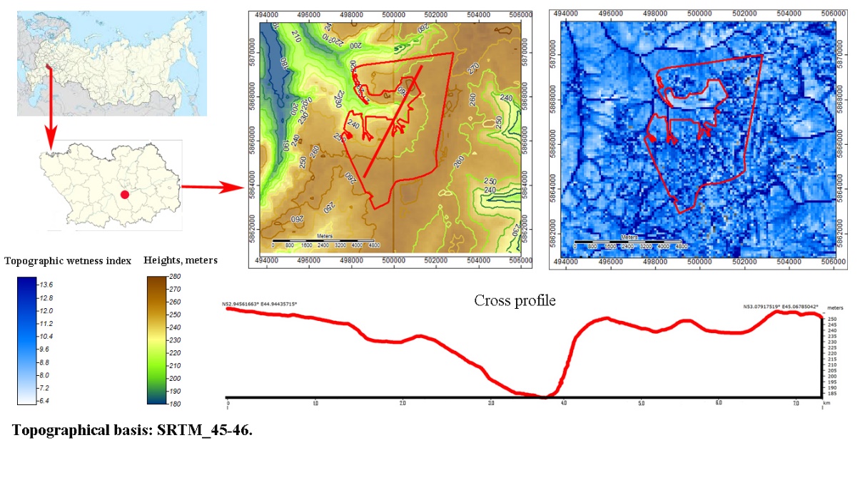
Taking into account the presented problems, the aim of the study is to develop the methodological foundations of geoinformation monitoring of water erosion on arable land. The object of study is a plot of agricultural land with the cadastral number 58:24:0000000:2419, east of the agricultural council of Staraya Kamenka, Penza district, Penza region. The subject of the research is the methods of geoinformation monitoring of water erosion of arable land.
Research Methods
The research methodology is based on the use of landscape-ecological analysis in the field with the obligatory photo and video recording of the study results. The work includes geological and geomorphological description, determination of the botanical composition of phytocenoses and soil. DEM satellite images were decrypted using SagaGIS tools: Contour Lines from Grid (which allows you to build horizontals), Basic Terrain Analysis (a universal topographic analysis tool, mapping slopes, LS-factor changes), Profile (profile building). Spectral analysis was performed using satellite imagery Landsat-8. The spectral channels are superimposed in the following sequence: Near Infrared-Shortwave Infrared-Blue. This sequence is optimal for recognizing vegetation displayed in shades of red and orange (Suvorov & Kitov, 2013). Soils are highlighted in bluish and greenish colors (Fritz, 2013). In this case, eroded areas are revealed by lightening in tone, and thalwegs and erosion potholes – by darkening. Bluish hues indicate hydromorphic conditions of the area (Quinn, 2001).
Findings
Penza district of the Penza region is located in a temperate climate region of temperate climate (Dfb according to Kappen and Geiger’s classification) moderate hydration (hydrothermal coefficient slightly higher than 1.1). The sum of the biologically active temperatures (temperatures above 10 ℃) exceeds 2300 ℃. The average annual rainfall is 536 mm / year, of which 288 mm falls in the summer period, when it rains most often. The descent of the snow cover is observed on April 7-24. At the same time, friendly springs happen. Consequently, the development of erosion processes is caused by storm runoff resulting from snowmelt and rain showers in summer (Lomov, Spiridonova, Solodkov, Lyganov, & Khisyametdinova, 2017).
The object of study is located within the structural denudation plain - the western spurs of the Surskaya Shishka, composed of sands and sandstones of the Saratov suite of the Paleogene age. The height differences within the study area vary from 180 to 280 metres above sea level (Figure
The field studies in the southern part of the land site with the highest moisture coefficient showed a disturbed gleyed soil profile that corresponds to texture-differentiated gleyed abrasives: BT-G-CG. The undermining was carried out to a depth of 40 cm, which exposed the mother rock - sandstones and sandy loam of the Paleogene age. The arable horizon is not expressed, which does not allow the soil to be attributed to agrozems (Golosov, Gusarov, Litin, Yermolaev, Safina, & Kiryukhina, 2017). The sod (gray-humus) horizon is thin (not more than 5 cm), light gray in color with brownish smears of loamy composition gradually turning into a texture-differentiated horizon of mosaic color. At a depth of 30-40 cm there is a glue strongly skeletal horizon of light gray color with an abundance of reddish spots and whitish inclusions of sandy loam sandstone. At a depth of 37-40 cm, the horizon is waterlogged and lies on the surface of large sandstone. The development of the abrasem is connected to the flushing of the upper part of the gray-humus AY and humus-elluvial AEL horizons by the surface runoff (Zhang & Zhang, 2011). The further development of soils, taking into account their restoration after anti-erosion measures, is possible in sod-gley soils.
Cannabis sativa L. и Solanum tuberosum L. are grown on arable land. On steam fields they grow Achellea millefolium L., Taraxacum officinale L., Polypogon monspeliensis L., Tanacetum vulgare L. and others. Single shrubs are compactly located and reflect the remnants of anti-erosion measures remaining from the Soviet era (as evidenced by satellite images Landsat-5 from 1989). Forest belts are preserved in small areas and are represented by Betula pendula L. and Rosa majalis L.
In the images of the mission Landsat 8 over the period 2007-2018 (Figure
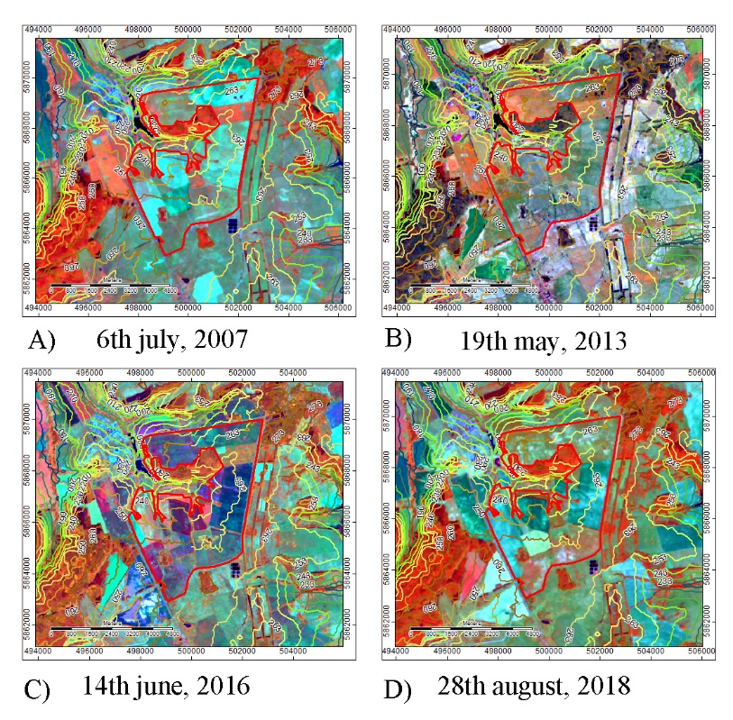
Dynamically erosive processes occur in the eastern and southern parts of the land. This is determined by its geomorphology: the northern slopes are very gentle (steepness less than 3 °) and have many closed depressions, while the southern and eastern slopes are gentle (more than 4 °) and have a wide gulf area where the fine earth runoff takes place (Figure
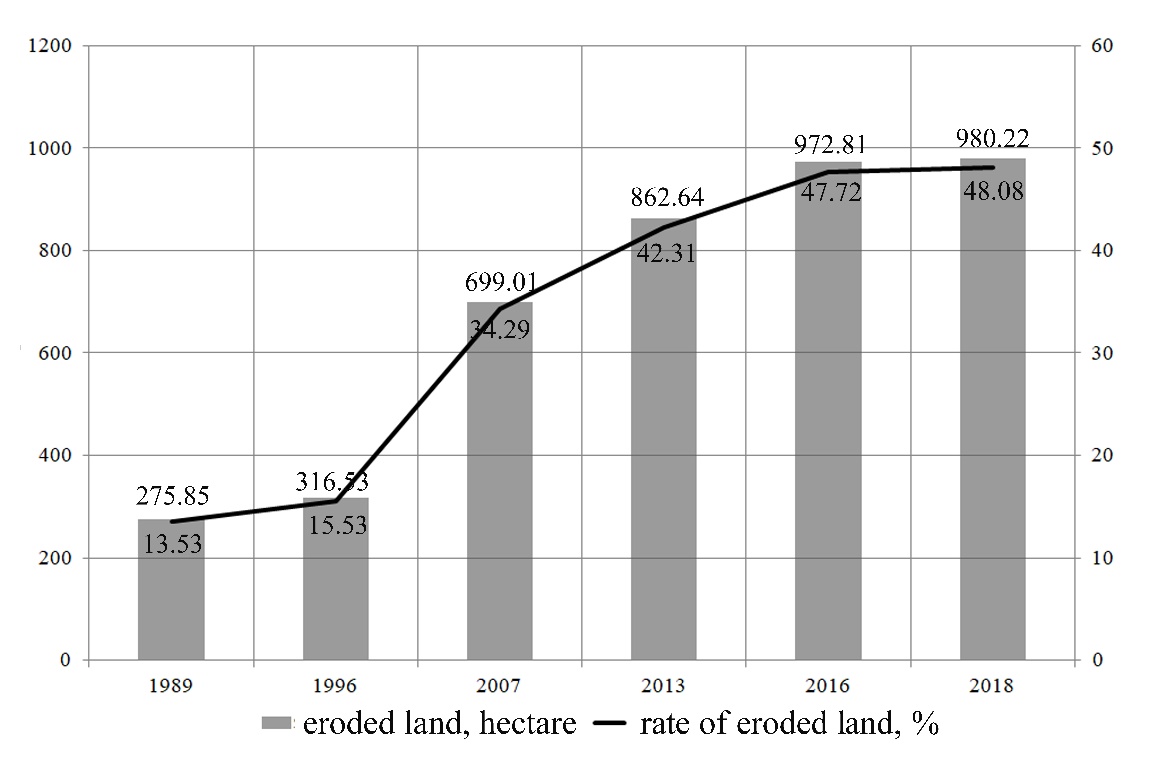
The results of calculations of the dynamics of eroded areas for 1989-2018 showed that the development of land erosion occurs rapidly: from 275.85 hectares in 1989 to 980.22 hectares in 2018. If at the beginning of the observation period the territory can be characterized as slightly eroded, then by the end it can be described as highly erosion-dissected. So, in 2018, less than half of the land plot was covered by erosion (48.08%). The transfer of the work sites to steam in 2017-2018 allowed to reduce the rate of erosion development to 3.7 ha / year. However, for the period 2007-2013 an average of 27.27 hectares became eroded annually, and for the period 2013-2016 the erosion rate reached 36.72 ha / year (Figure
Land degradation indicates the destruction of the existing natural and anthropogenic landscape of a larger territorial level (Comino et al., 2016). In this connection, it seems necessary to conduct large-scale studies, on the basis of which a system of anti-erosion measures and erosion control at the state level will be developed. Unfortunately, supervision in this area is not organized systematically. A methodology for determining agricultural land erosion in Russia has not been developed yet. The proposed technology of geographic information monitoring can become its basis and be implemented as part of the activities of the Federal Service for State Registration, Cadastre and Cartography (Rosreestr). In this regard, the formation of strategies and plans for sustainable development of territories should be based on the results of GIS monitoring, obtained from a single database.
Conclusion
The development of strategies and programs for sustainable socio-economic development of rural areas should be based on geoinformation monitoring of the land. The degradation of fertile agricultural land in Russia happens mainly due to the development of water erosion. The use of satellite sensing data makes it possible to identify these processes.
Decoding Landsat5-8 mission satellite images in the combination of colours Near Infrared-Shortwave Infrared-Blue together with the overlay of DEM SRTM survey data allowed to identify and characterize erosion processes in one of the plots of agricultural land of the Penza region.
The information was obtained about the geomorphological structure of the research object, which is included in the drainage basin of a large ravine-erosion complex. The territory is cup-shaped open to the spur of the ravine and has an asymmetry of slopes: the northern is more gentle than the southern one. Hence, the development of erosion processes occurs more actively in the southern and southwestern areas.
Field soil and botanical studies showed overgrowing with weeds, and gray forest soils on the southern slope are washed away and represented by a texture-differentiated gleyized agrozem. The clay composition of soils and their close occurrence to the surface of the Paleogene sandstones contributes to the erosion of humus material.
The satellite images processed by the SagaGIS program made it possible to identify and calculate eroded land plots, as well as to restore their dynamics over the past 29 years. The degradation is rapidly developing. During this time, the degree of erosion has changed from slightly to strongly eroded. The growth of the destroyed lands amounted to 5-10% per year of the total land area. Transferring some of the fields to steam allowed to reduce the speed of this process.
The reason for the observed processes is the lack of anti-erosion measures, irrational land use as well as the imperfect monitoring of erosive land in the region. The use of modern geoinformation technologies based on integrated monitoring using remote sensing methods and field research allows us to approach the preservation of agricultural land at a new highly effective level: to determine the dynamics of erosion processes and recommend the necessary anti-erosion measures to land owners.
References
- Comino, J. R., Iserloh, T., Lassu, T., Cerda, A., Keestra, S. D., Prosdocimi, M., Brings, C., … and Ries, J. B. (2016). Quantitative comparison of initial soil erosion processes and runoff generation in Spanish and German vineyards. Science of the total Environment, 565, 1165-1174. DOI:
- Fritz, S. (2013). Downgrading recent estimates of land available for biofuel production. Environ. Sci. Technol, 47, 1688-1694. DOI:
- Fritz, S. (2015). Mapping global cropland and field size. Glob. Change Biol, 21, 1980-1992. DOI:
- Golosov, V., Gusarov, A., Litin, L., Yermolaev, O., Safina, G., & Kiryukhina, Z. (2017). Evaluation of soil erosion rates in the southern half of the Russian Plain: methodology and initial results. Proceeding of the International Association of Hydrological Sciences. Proc. IAHS, 375, 23-27. DOI:
- Kamp, J. (2014). Land management: Weighing up reuse of Soviet croplands. Nature, 505, 483.
- Lomov, S. P., Spiridonova, I. N., Solodkov, N. N., Lyganov, A. V., and Khisyametdinova, A. A. (2017). Modern and burned soil of Kurgans in the forest-steppe zone of the Middle Volga region (by the example of Komintern I kugan). Eurasian Soil Science, 5, 539-548. DOI:
- Quinn, J. W. (2001). Portland state university education. Retrieved from http://web.pdx.edu/~emch /ip1/bandcombinations.html
- Suvorov, E. G., & Kitov, A. D. (2013). Landscape structure of the southeastern part of Eastern Sayan. Geography and Natural Resources, 34(4), 371-377. DOI:
- Tarnocai, C., Canadell, J. G., Schuur, E. A. G., Kuhry, P., Mazhitova, G., & Zimov, S. (2009). Soil organic carbon pools in the northern circumpolar permafrost region. Global Bioogeochemical Cycles, 23. GB2023. DOI:
- Zhang, S., & Zhang, X. (2011). Soil loss, crop growth, and economic margins under different management systems on a sloping field in the black soil area of Northeast China. Journal of Sustainable Agriculture, 35, 293-311. DOI: 10.1080/10440046.2011.554307
Copyright information

This work is licensed under a Creative Commons Attribution-NonCommercial-NoDerivatives 4.0 International License.
About this article
Publication Date
31 December 2019
Article Doi
eBook ISBN
978-1-80296-076-1
Publisher
Future Academy
Volume
77
Print ISBN (optional)
-
Edition Number
1st Edition
Pages
1-1056
Subjects
Industry, industrial studies, project management, sustainability, business, innovation
Cite this article as:
Patturi, Y., Malyshev*, A., & Solodkov, N. (2019). Geoinformation Monitoring Possibilities In Ensuring Sustainable Development Of Regions. In I. O. Petrovna (Ed.), Project Management in the Regions of Russia, vol 77. European Proceedings of Social and Behavioural Sciences (pp. 856-862). Future Academy. https://doi.org/10.15405/epsbs.2019.12.05.104