
Geological And Geo-Electrical Resistivity Studies Of Mukah Coalfield Area, Sarawak, Malaysia

Abstract
Tertiary coal seams in Mukah Coalfield appear to be discontinuous laterally in terms of depth and thickness of the seams. This may be attributed from the tectonic events that occurred in the past which had also resulted in the formation of Teres-Bakau anticline and Badengan syncline found in this area. Numerous localized faults with significant displacement commonly occur in the Mukah Coalfield which increases the tectonic complexity of the area. This complexity poses a challenge in estimating the volume of coal that can be economically extracted. The Geo-electrical Resistivity survey was conducted to delineate the coal seams in the Mukah Coalfield area in order to determine the continuity of the coal seams. It is found that the extension of the coal is found with the values of 80 – 200 Ohm.m at the elevation of 20 m until - 5 m and is dipping towards South. A few faults have been identified due to inconsistency in depth of coal seam.
Keywords: “Tertiary Coal”“Mukah Coalfield”“Geo-electrical Resistivity”
Introduction
In general, there are two important things that have to be determined before the extraction of the coal could be proceed which are; (I) the volume of coal that can be extracted economically considering the factors of the cost to assess minable reserves, environmental issues, marketable reserves, potential markets and permitting risk and (ii) any factors that have the potential of affecting the mining of the coal deposits such as geological structures and hydrogeology of the area which all these information will determine the future mining design such as the type of mine that will be set up, the position of any shaft and plant preparation (Kang, 2009).
Some areas that have a lot of tectonic activity such as Mukah Coalfield area, the coal seam is appeared to be discontinuous laterally in terms of its depth and thickness of the seams. This is evidenced by the formation of structural features found in the Mukah Coalfield area which are the Teres-Bakau Anticline and Bedengan Syncline respectively (Sia, Abdullah, Konjing, & Koraini, 2014). Moreover, local faults with significant displacement are common in the area of Mukah Coalfield which increases the tectonic complexity of the area (Nugraheni, Chow, Abdul Hadi, Siti Nuralia, & Abdullah, 2014). Thus, it is challenging task to estimate the volume of coal that can be economically extracted. Therefore, it is necessary to delineate the coal seam in the subsurface in order to find out the direction of the coal extension. Delineating the coal seam can reveal if there is any coal splitting and the dip of the coal seam can also be known. Coal splitting occurs when a coal seam is split or separated into two or more seams by non-coal layer. This feature occurs due to interruption of clastic sedimentation during organic accumulation which may occur once or many times during the deposition of the coal seam (Thomas, 2012). These features can be determined by using geophysics survey in order to illustrate the subsurface morphology of the coalfield. Besides, this information is crucial for determining the economic potential of the coal seam.
In this research, the geophysical method used is Electrical Resistivity. High resistivity values of coal seam compared to other surrounding sedimentary rock strata makes them very responsive to the electrical resistivity survey. This allows the coal seam to be easily detected in the result and can be clearly differentiated from other types of rock.
The main objective of this research is to detect and delineate the vertical and lateral extension of coal seams in the Balingian Formation at Mukah Coalfield. Besides, this study was also carried out to conduct a geological mapping in order to construct a geological map of the research area in Mukah Coalfield. Moreover, in order to illustrate the distribution of coal seams, the 2D Electrical Resistivity pseudo-section model are generated and the continuity of coal seams are evaluated in terms of the dipping of coal seams and coal splitting occurrences.
Problem Statement
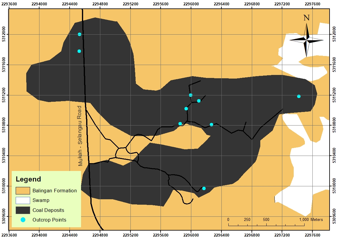
There are numerous of studies that has been conducted in Mukah Coalfield and a few geological maps had been generated from these studies. However, these geological maps were generated from the data collected by geological surveys on surface only. Besides, the maps are showing the whole Mukah Coalfield area and lots of insufficient data on these geological maps by the previous study. Thus, a new geological map is required to be constructed, which it will be more focus on coal seams specifically at the research area where the data is collected from surface and subsurface areas.
Moreover, the unidentified dipping of coal seams and the occurrence of coal seam splitting are the reason why the amount of economic potential of coal deposit cannot be accurately determined. In order to obtain this information, the coal seams have to be delineated vertically and laterally in order to know the dip direction of the coal seam which can be obtained by using geo-electrical resistivity. Despite its importance, little publication on geophysics studies conducted in Balingian Formation specifically from Mukah Coalfield. Therefore, a research will be conducted to study the geophysical characteristic and extension of the coal seam vertically and laterally in Mukah Coalfield.
Research Questions
-
How is the distribution of coal seams in the research area in Mukah Coalfield as the tectonic complexity is high on the surface of Mukah Coalfield, thus may affect the depth and thickness of the coal seam in the subsurface?
-
What is the average resistivity value of coal in the Mukah Coalfield as the range of value of resistivity are different in different area?
-
What is the magnitude of dip of the coal seam and location of the coal splitting (if any) so that the distribution of the coal seam can be predicted for future extraction?
Purpose of the Study
The main objective of this research is to detect and delineate the vertical and lateral extension of coal seams in the Balingian Formation at Mukah Coalfield. Besides, this study was also carried out to conduct a geological mapping in order to construct a geological map of the research area in Mukah Coalfield. Moreover, in order to illustrate the distribution of coal seams, the 2D Electrical Resistivity pseudo-section model are generated and the continuity of coal seams are evaluated in terms of the dipping of coal seams and coal splitting occurrences.
Research Methods
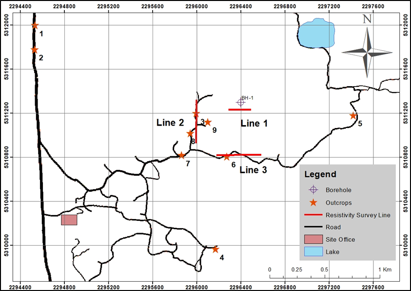
There are two different methods that were used in this research study which are Geological Survey and Geo-electrical Resistivity.
Geological survey
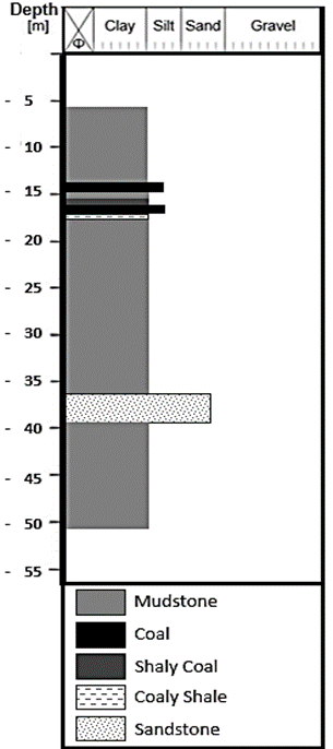
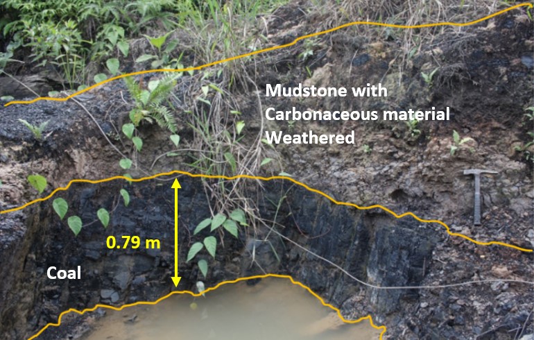
The geological survey includes the recognition and tracing of marker bed and the study of the lithology of the outcrop available in the study area. The information gathered from these outcrops includes strike and dip, the thickness of beds and length of the outcrops. The data collected is essential in the study of the structural geology of the area and helps in interpreting the results later. A borehole (BH-1), was also be used in this study in order to integrate with the results and produce a more clear interpretation of the result (Table
Geo-electrical resistivity
Geo-electrical resistivity survey is one of the widely used methods in mineral exploration beside also has been a practice in the fields of geohydrology, environmental science and engineering (Adli, Musa, & Arifin, 2010). The resistivity survey method measures two potential electric currents that pass through the subsurface by injecting current into the ground through two current electrodes. From one electrode to another, the potential difference is recorded thus the resistivity between two points can be obtained. The resistance at the specific point in the subsurface can be determined from the measured voltage (V) and current (I) values.
The resistivity data were acquired using ABEM Terrameter SAS 4000 and a switcher unit was used as a controller for the induction of current and potential readings from electrodes connected by multicore cable along the survey line. Three resistivity survey lines were laid out by using the Schlumberger–Wenner configuration. Two of the lines have a length of 400 m and one line with the length of 200 m which all three of them have the spacing between each electrode of 5 m. The Geo-electrical Resistivity survey was conducted using Schlumberger–Wenner Configuration as the coverage is moderately good in horizontal and vertical subsurface (Loke & Barker, 1996). The resistivity data recorded were interpreted and analysed by using the software RES2DINV.
Findings
Geological survey
Figure
Geo-electrical Resistivity survey
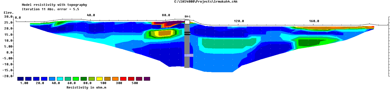
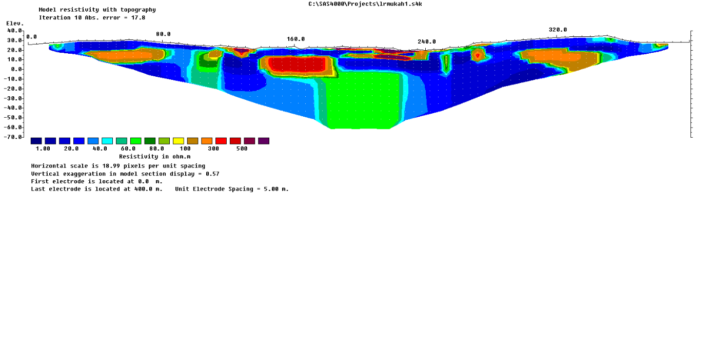
Geo-electrical Resistivity Line 1
A low resistivity zone is shown in Figure
Geo-electrical Resistivity Line 2
Geo-electrical resistivity profile of Line 2 which trending North-South in Figure
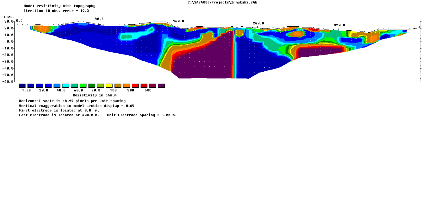
Geo-electrical Resistivity Line 3
Based on the resistivity profile of Line 1 and 2, the high resistivity zone with the values of 90 – 200 Ohm.m is representing the coal seam. Thus, for this resistivity profile of Line 3 in Figure 08, a similar thin layer of low resistivity values (1- 40 Ohm.m) at the elevation of 30 m until 20 m is representing the mudstone that is normally found on the surface of Mukah Coalfield as referred to the borehole data and outcrops. A layer of high resistivity zones with the values of 100 – 400 Ohm.m are found at the elevation of 20 m to -5 m are referred as coal seam that has been separated which might due to minor fault as shown in Figure 08. This explained why this seam is separated by a significantly low resistivity value which are 1 – 30 Ohm.m because this fault might be filled with water or air. Besides, where this low resistive zone is found at this elevation, the upper part of this area has a high resistive zone. Thus, this might due to the fault has made the high resistive zone or coal seam displaced to the upper part, which is why there is Outcrop 6 where the patches of coal were found on the surface of Line 3.
Conclusion
The results shown in this paper provide evidence that the Geo-electrical resistivity can be successfully applied in coal exploration as these results show the distribution of coal seam in Mukah Coalfield area. The high resistivity zone is detected with the values of around 80 – 200 Ohm.m which is interpreted as coal as it is integrated with the borehole data BH-1 and outcrop data. These coal seams or high resistivity value layers are found at the elevation of 20 m - 10 m in the northern part (Resistivity line 1) and at deeper depth at the southern part (Resistivity Line 3) which is at the elevation 20 m to -5 m. This correspond well with the outcrop data on the surface of Mukah Coalfield as it also shows that the coal is gently dipping towards South at 5-6̊. There is a possible fault that is found at Line 3 where it shows that the coal seam is separated with significantly low resistivity value zones as the minor fault that filled with water might be the reason of this low resistive zone. In summary, based on this research, the tertiary coal seam in Mukah Coalfield area is found to be not continuous and might due to faulting and not because of coal splitting as presented by the integration of geological and geo-electrical resistivity results. The future studies will provide the link between these individual resistivity results and the whole coal distribution and extension of the Mukah Coalfield area.
References
- Adli, Z. H., Musa, M. H., & Arifin, M. N. K. (2010). Electrical Resistivity of Subsurface : Field and Laboratory Assessment, 4(9), 799–802.
- Kang, L. (2009). Coal Exploration and Mining. In Coal, Oil Shale, Natural Bitumen, Heavy Oil and Peat (Vol. I, pp. 92–112).
- Loke, M. H., & Barker, R. D. (1996). Practical techniques for 3D resistivity surveys and data inversion1. Geophysical Prospecting, 44(3), 499–523.
- Nugraheni, R. D., Chow, W. S., Abdul Hadi, A. R., Siti Nuralia, M. N., & Abdullah, M. F. (2014). Tertiary coal-bearing heterolithic packages as low permeability reservoir rocks in the Balingian Sub-basin, Sarawak, Malaysia. Bulletin of the Geological Society of Malaysia, 60(December), 85–93.
- Sia, S. G., Abdullah, W. H., Konjing, Z., & Koraini, A. M. (2014). The age, palaeoclimate, palaeovegetation, coal seam architecture/mire types, paleodepositional environments and thermal maturity of syn-collision paralic coal from Mukah, Sarawak, Malaysia. Journal of Asian Earth Sciences, 81, 1–19.
- Thomas, L. (2012). Coal Geology. Chichester, UK: John Wiley & Sons, Ltd. https://doi.org/10.1002/9781118385685
Copyright information

This work is licensed under a Creative Commons Attribution-NonCommercial-NoDerivatives 4.0 International License.
About this article
Publication Date
17 May 2019
Article Doi
eBook ISBN
978-1-80296-061-7
Publisher
Future Academy
Volume
62
Print ISBN (optional)
-
Edition Number
1st Edition
Pages
1-539
Subjects
Business, innovation, sustainability, environment, green business, environmental issues
Cite this article as:
Amin Zakariah, M. N., Mustapha, K. A., Zainal Abidin, N. S., Ismail, M. S., & Mohd Rosdi*, N. (2019). Geological And Geo-Electrical Resistivity Studies Of Mukah Coalfield Area, Sarawak, Malaysia. In M. Imran Qureshi (Ed.), Technology & Society: A Multidisciplinary Pathway for Sustainable Development, vol 62. European Proceedings of Social and Behavioural Sciences (pp. 222-229). Future Academy. https://doi.org/10.15405/epsbs.2019.05.02.21