
Ber Mounds On The Territory Of Kalmykia And The Caspian Sea


Abstract
The article deals with the history of the origin of the Baer hills on the territory of the Republic of Kalmykia and the Caspian Sea. The main hypotheses of the origin of the Baer mounds are considered: erosive, Aeolian, and tectonic. The distribution of the Baer mounds on the territory of the Republic of Kalmykia has been investigated and established according to the data of decoding of small and medium-scale satellite photographs, as well as ground observations. The structure of hillocks and inter-hill depressions were studied as a result of the generalization of materials of engineering-geological surveys. The Republic of Kalmykia is one of the driest regions in the southeastern part of Russia and Europe. They are characterized by climatic parameters with an average annual temperature of 9–11 °C and the duration of the thermal period up to 180 days a year. The level of active radiation is 130–135 kcal/hour per m2. There are numerous studies and hypotheses about the formation of Baer mounds. In appearance, the Baer mounds are undulating hollow-convex hills, asymmetrical, separated by depressions of hollow-concave and trough-shaped shapes, and have sizes from 5 to 25 meters high.
Keywords: Geology, Hillocks of Baer, landscapes, ridge, topography, territory
Introduction
Various studies have been devoted to the study of the properties and characteristics of the Baer mounds. Most of the works have been published by scientists and collaborators interested in the problems of the Caspian Sea as a whole and its regions. The works of Baer (1856), Groswald (1999) and articles by Golovachev (2017), Nazarov et al. (1876) are devoted to the study of Baer's mounds (Bankurova, 2015; Sangadzhiev, 2015). Some questions on Baer's mounds were previously published in the monograph by Kharchenko and others.
Problem Statement
Various studies have been devoted to the study of the properties and characteristics of the Baer mounds. Most of the works have been published by scientists and collaborators interested in the problems of the Caspian Sea as a whole and its regions. The works of Baer (1856), Groswald (1999) and articles by Golovachev (2017), Nazarov et al. (1876), Tsutskina are devoted to the study of Baer's mounds. Some questions on Baer's mounds were previously published in the monograph by Kharchenko and others. The main part of the Baer hills is located at a distance of 100–150 km from the coastline of the modern Caspian Sea. Undulating hills are mainly composed of Mesozoic and Paleozoic rocks. These changes in the shape of the relief are most likely due to the internal and external dynamics of the earth. The picture of their origin has been described by various scientists with the involvement of such factors as the rapid decline of sea waters as a result of the catastrophic lowering of the Caspian Sea level (Rem), erosion (Rosen, Zhukov), glacial accumulation (Golynets), tectonics (Korolev), the impact of various exog.
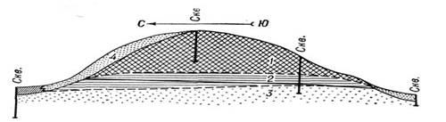
Basically, of course, these are not hillocks in the sense that we are used to seeing, but elongated hills (Table 01; Figure 01). Sometimes they were also called uvalas, which are located singly or in groups in the northern part of the Caspian sandy massif east and south-east of the Ergeninsky upland. For more than 50 thousand years, the outskirts of the hill were washed by the ancient Caspian Sea. Uvalas are mostly located in a chain, sometimes there are disconnected uvalas. The distance between them is on average about a kilometer or more (Kapustin et al., 1986). They have a height of up to 20 meters and a width of no more than 200 meters, sometimes longer. And so their heights reach 6–11 m with smoothed corners. This is due to strong winds. There is a process of wind erosion. The most acceptable hypothesis accepted by scientists is Aeolian and erosive. For his concept, scientists have adopted and clarified the very name of the Baer hillock. These are mainly linear-elongated, undulating hills concentrated on the area of the Caspian lowland between the lower reaches of the Volga River and the Kuma River due to the gradual outflow.
Research Questions
Expeditions were conducted to Yashkul, Chernozemelsky, Virgin, Justinsky, Maloderbetovsky districts of Kalmykia. In the photo taken by the staff of KalmSU and MSU, we observed some features of these formations. Undulating hills are mainly composed of Mesozoic and Paleozoic rocks. These changes in the shape of the relief are most likely due to the internal and external dynamics of the earth. The picture of their origin has been described by various scientists with the involvement of such factors as the rapid decline of sea waters as a result of the catastrophic lowering of the Caspian Sea (Rem), erosion (Rosen, Zhukov), glacial accumulation (Golynets), tectonics (Korolev), the impact of various exogenous factors (Muskets), etc. The most acceptable hypothesis accepted by scientists is Aeolian and erosive. For his concept, scientists have adopted and clarified the very name of the Baer hillock. These are mainly linear-elongated, undulating hills concentrated on the area of the Caspian lowland between the lower reaches of the Volga River and the Kuma River.
Purpose of the Study
To understand the current state of the Baer hills in the study area, we will turn to some historical facts. Let's consider historically in the era of glaciation (70–11 thousand years ago) the level of the Caspian Sea (the Caspian has more than 70 names, here are only the most famous names of the Khazar, Khvalynsky). According to scientists, more than 17 centuries ago, due to a sharp warming, timed to the melting of glaciers and permafrost, there was a large flood in the river valleys. We observed this on the Yashkul River, where the ancient riverbed is up to 2–3 km wide (photo 4). All this led to a real flood
Let's consider historically in the era of glaciation (70–11 thousand years ago) the level of the Caspian Sea (the Caspian has more than 70 names, here are only the most famous names of the Khazar, Khvalynsky). According to scientists, more than 17 centuries ago, due to sharp warming, timed to the melting of glaciers and permafrost, there was a large flood in the river valleys. We observed this on the Yashkul River, where the ancient riverbed is up to 2–3 km wide (photo 4). All this led to a real flood. The Khvalyn transgression (the onset of the sea on land) lasted about 6 centuries with oscillation cycles of an average of 2 thousand years. According to scientists, the water level rose to 180 meters and reached +50 m above ocean level. The rise itself lasted more than 100 years. Since, from the point of view of history, the time of geological processes is small, therefore, we do not observe gravel and coarse deposits in the lowlands of the Caspian Sea. There were huge quantities of shellfish in the lowlands of the sea, especially in warm places. Due to the dynamics of the sea, they died off, and deposits of rock were formed.
The geometric parameters of the sea oscillation were up to 2 meters vertically with the speed of movement of the coastline – 20 km /year. For example, the current fluctuations are an order of magnitude lower. But even this is considered catastrophic in the modern world. The area of flooding in the Khvalyn basin was huge, and the level of the Caspian Sea rose by 80 meters or more. The Volga River reached Cheboksary. This proves the hypothesis about the appearance of the Baer mounds in the upper part of the Volga River delta. Thus, the Caspian washed the shores of the Ergeninsky upland in the west and in the northeast in the form of a lip that reached the modern territory of Cheboksary. The sea flooded the Kura Depression, the Caucasus coast, the West Turkmen Lowland, and the low Karakum mountains. To date, the question of the origin of the Baer mounds remains open, but there is a tendency to solve it from the standpoint of an integrated approach. It is based on the analysis of numerous geological and geophysical materials and the results of the decoding of aerial and space photographs of various scales. The systematic approach allows us to consider and distinguish the areas of the distribution of the Baer mounds as a kind of geosystem, mainly due to three factors: tectonics, lithology, and climate.
Research Methods
To investigate and consider the problems of anthropogenic landscapes of the steppe zone and their changes, mineralogy of the steppe, monitoring of the lithosphere and soils, flora on the territory of Kalmykia.
Findings
To date, the question of the origin of the Baer mounds remains open, but there is a tendency to solve it from the standpoint of an integrated approach. It is based on the analysis of numerous geological and geophysical material and the results of the decoding of aerial and space photographs of various scales. The systematic approach allows us to consider and distinguish the areas of the distribution of the Baer mounds as a kind of geosystem, mainly due to three factors: tectonics, lithology and climate.
Conclusion
The emergence of this limitation was due to the genesis of the hills and the fact that at that time Baer was not yet aware of similar forms of mesorelief from other areas of the Caspian Sea. This formulation was proposed later. The question of the genesis of the Baer hills cannot yet be considered fully resolved, however, it is most likely to explain their origin due to the erosion of waters rushing from the continent in various directions following the retreating coastline of the Caspian Sea, which regressed stagially in the second half of the Khvalynsky century. The Aeolian factor plays only a modest role in the subsequent modeling of hillocks.
Attention is paid to the historical past of the Caspian Sea, the Caspian Sea and Kalmykia from a geological point of view, an analysis of the climatic features of the territory of the republic is carried out, studies are carried out by students of the Faculty of Engineering and Technology of Kalmyk State University together with the Faculty of Geography of Moscow State University. Using aerial and space photographs, data from deep drilling and geophysics from the perspective of a complex transition on the territory of Kalmykia, the Baer mounds, their orientation, structural and tectonic confinement were identified, an attempt was made to explain the nature of their formation and engineering-geological characteristics of the soils of the Baer mounds were given.
References
Baer, K. M. (1856). Scientific notes on the Caspian Sea and its environs. SPb. Printing House Imperat. Academy of Sciences.
Bankurova, R. U. (2015). Influence of anthropogenic factors on the dynamics of ecosystems of the North-Western Caspian region, Young Scientist, 23, 401–404. https://moluch.ru/archive/103/23999/
Golovachev, I. V. (2017). About Baer knolls and their origin. Geology, geography and global energy, 4(67), 139–149. https://geo.asu.edu.ru/files/4(67)/139-149.pdf
Groswald, M. G. (1999). Eurasian hydrospheric catastrophes and glaciation of the Arctic. Moscow, Scientific world.
Kapustin, I. N., Kiryukhin, L. G., & Molodykh, G. N. (1986). Geological structure and oil and gas potential of Kalmykia. Kalm. book. publishing house.
Nazarov, A. G., Tsutskin, E. V., & Baer, K. M. (1876). Geological structure. Nauka.
Sangadzhiev, M. M. (2015). Features of subsoil use on the territory of the Republic of Kalmykia. Elista. Publishing house of Kalm.un-ta.
Copyright information

This work is licensed under a Creative Commons Attribution-NonCommercial-NoDerivatives 4.0 International License.
About this article
Publication Date
23 December 2022
Article Doi
eBook ISBN
978-1-80296-128-7
Publisher
European Publisher
Volume
129
Print ISBN (optional)
-
Edition Number
1st Edition
Pages
1-1335
Subjects
Science, philosophy, academic community, scientific progress, education, methodology of science, academic communication
Cite this article as:
Dzhalchinova, T. B., Sangadzhiev, M. M., Badrudinova, A. N., Sangadzhieva, R. S., & Arashev, A. V. (2022). Ber Mounds On The Territory Of Kalmykia And The Caspian Sea. In D. K. Bataev, S. A. Gapurov, A. D. Osmaev, V. K. Akaev, L. M. Idigova, M. R. Ovhadov, A. R. Salgiriev, & M. M. Betilmerzaeva (Eds.), Knowledge, Man and Civilization- ISCKMC 2022, vol 129. European Proceedings of Social and Behavioural Sciences (pp. 360-365). European Publisher. https://doi.org/10.15405/epsbs.2022.12.45