
The Benefit Of Agro-Scientific Expert Knowledge For Soil Waterlogging Risk Assessment


Abstract
Sustainable Development Goals prioritize the prevention of agricultural soils from degradation, and risk assessment is needed to quantify the threads at national and regional levels. Such assessment is, however, delayed by the large tangle of problems involved, which result from the poorly estimates interaction of soil properties, climatic variables, and land management practices. Methodologies for risk assessment of soil threats are needed to guide management for avoidance of greater risks in the future based on the situation in the past and now. We present here an example for the developed Bayesian Belief Networks (BBNs) to estimate the risk of Russian Chernozem waterlogging as one notable soil degradation risk. The topsoil’s (upper 50 cm) waterlogging duration (exposure) as a given threat is determined in terms of probability from inherent soil properties as from climatic and anthropogenic factors influencing the processes involved in water balance trough those properties. The BBN allows for combining available data from management practice manuals and databases with qualitative expert knowledge and explicitly accounts for uncertainties. With BBN we were able to answer the question, if one land management technology is significantly more efficient against waterlogging than the other given climate variability from the weather station series in Tambov region, Central Russia.
Keywords: Bayesian Belief Network, climate change, waterlogging
Introduction
In a framework of sustainable development goals, the prevention of soil degradation is among the highest priority. As the natural ecosystems are shrunken smaller areas, the demand to sustain soil ecological function becomes more urgent for agricultural soils, especially those in active use, such as Russian Chermozems. Soil threats include erosion, compaction, loss of organic matter and humus-bounds-nutrients, salinisation, landslides and other minor things. In many of those threads anthropogenic press and climate change and variability interact in a complex manner. One additional thread tightly linked to a changing climate is soil waterlogging. Not as dangerous as desertification it however excludes the land from free-of-water management agricultural use a put a dilemma of drainage or alternative use (e.g., farm grass production). As with many risks it is sometimes difficult to gather all data for process-based assessment of the problem. But expert opinion is often quantitative and lacks critical evaluation and explicit statistical assessment of associated uncertainty in each opinion and difference between them.
Problem Statement
It is proposed by known experts (Parakshin & Zaidelman) that the increase in waterlogged arable land in the agricultural landscapes of the Tambov region occurs at a rate of 4 to 10 thousand hectares per year at the lowest one in the period before the 2000s (Edelgeriev, 2020). It is recognized that secondary waterlogged soils are found in various regions of the steppe and forest-steppe zones, but there is still insufficient data for a quantitative analysis of the distribution of this phenomenon.
Surveys conducted by the Soil Institute indicate significant differences between the actual soil cover of the Central Chernozem region as it is in 2017-2020 and the content of soil maps in the 70s and 80s, but observations in midpoints in time are fragmentary and not covering all the mapped areas. This applies, first of all, to meadow chernozem and other waterlogged soils, which are diagnosed in place of chernozems shown on maps of different scales. The discrepancy between the historical and modern soil surveys is associated with both natural (climate) and anthropogenic (soil compaction, flooding) changes in recent decades, and with methodological errors in field diagnostics of soil waterlogging in the chernozem zone. It is not yet clear if the process of wetting the soils in continuous of already reversed in slightly drying climate of recent decade. In any case, this discrepancy has a very negative impact on the results of agricultural activities. The practice of using lands in the forest-steppe zone has developed in relation to zonal soils - leached chernozems, and typical chermozems. The ideas of the agronomic community about their predominance and the corresponding steppe farming systems are practiced to this day without any adjustments. Meanwhile, the inadequacy of these systems to actual conditions becomes more and more obvious in connection with the development of science-intensive landscape-adaptive agricultural technologies (Kiryushin, 2019). Many agro-technologies are in place that could reverse waterlogging in wet years but avoid excessive soil drying in dry years, but intercomparing and evaluation of the critical impacts are very much in need from scientific society. Formal mathematical framework such as Bayesian Belief Network (BBN) was previously used for similar risk assessments of soil erosion and compaction (Aalders et al., 2011; Troldborg et al, 2013) and proven to be effective in cause-effect analysis to guide the management at the farm and regional level (Troldborg et al., 2018) and uncertainty quantification.
Research Questions
We put the following hypothesis as a research question: given the minimum and the maximum boundary for the technology-linked child nodes (properties), would it still be sensible to vary the time window of climate data to fit into the range of expert-defined range of waterlogging rate and if so how changes would look like under different scenarios of climate change. On the contrary, the second question is if one land management technology is significantly more efficient against waterlogging than the other given climate variability from the weather station series as deduced from revised expert knowledge and data.
Purpose of the Study
The purpose of the following study is to build the simple BBN that could be used for addressing the research question and test hypothesis on the role of the expert opinion in the formalized decision-making. With the example of this generic BBN structure and taking soil waterlogging as an example, we then aim to develop a more detailed BBN that combines available data from soil surveys on (A) soil physical properties (b) integral soil processes (downwelling and upwelling vertical water movement and evaporation).
Research Methods
In the weather and climate risk model proposed by the Intergovernmental Panel on Climate Change (IPCC), the risk consists of: 1) the frequency of a climatic (weather) event causing a hazard, 2) the facility's exposure to risk (its propensity to be adversely affected) and 3) the likelihood of the system being vulnerable to the hazard. The Hydrometeorological Center of Russia has developed a list of weather phenomena that cause risks to technical systems and ecosystems (Kobysheva et al., 2015). However, from this list, risks related to soils and land cover are only drought risks that are not directly related to soil degradation. For other processes and phenomena of soil degradation, the criteria for climatic risks in Russia have not been developed, just as the boundary of the acceptable level of risk has not been determined. A great deal of uncertainty also applies to the quantification of risk exposure.
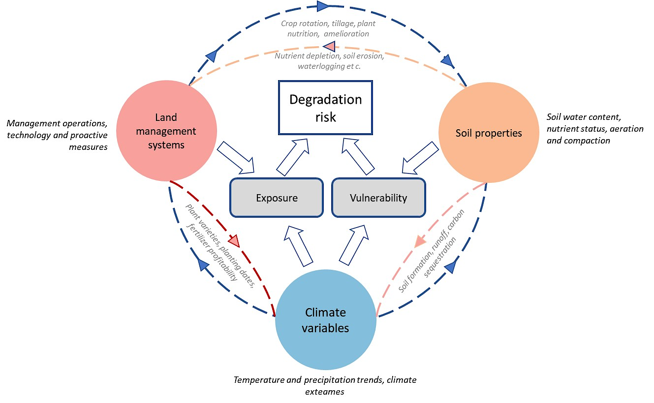
Figure 1 shows how an approach to assessing the risks of soil degradation can be implemented within the framework of a basic understanding of risks by the Intergovernmental Panel on Climate Change. The scheme is the most general prototype of a graph, the nodes of which give a discrete assessment of the operating factors, and the connections of the “child” (dependent) nodes of the factors “parents” that are parameterized in the form of conditional probabilities based on the regional data on degradation-related soil properties and expert assessments based on bulk of historical literature and communication.
Under these conditions, a promising method based on Bayesian networks of trust (BBN), which is a model of variables and their probabilistic relationships in the form of nodes and links in a graph were compiled by an expert. Relationships between variables are determined by conditional distribution probabilities. The method explicitly considers the uncertainty and variability in the forecast model and allows the inclusion of expert opinion in form of conditional probability matrices (Bayesian form) and correlation matrices (copula form). As a result, BBNs are becoming an increasingly popular method for modeling complex systems with a lack of quantitative knowledge. They have been proven to be effective in assessing the risks of agrogenic soil compaction (Troldborg et al., 2013) at the Environmental Protection Agency of Scotland (Troldborg et al, 2018). Based on this work, maps of risk gradations (low, medium, high) were compiled, as well as maps of their changes under different scenarios of climate change. BBNs allow estimates to be updated as new data become available, and are flexible and adaptable as opposed to deterministic, physically based approaches. Here we define the active layer for which we assume the waterlogging affects the root zone and plant production as upper 50 cm. Waterlogging itself is defined here as the presence of water above the field capacity in the active horizon for M days, where M is one of the model parameters to be defined.
Findings
The constructed structure of the BBNs is given in Table 1, which lists all children nodes in the left column and linked parent nodes in the right column. The inherent soil and site characteristics of nodes in the BBN are all parentless and their state values (probability tables) are drawn empirically from available in the regional literature for Tambov region, Central Russia. Parent nodes at the corresponding levels are:
- Level 0 (outer Parents) atmospheric water input (A), soil group (S), temperature (T), plant evaporation demand (P) and soil compaction (C).
- Level 1 (Children) runoff (R), infiltrated water supply (IS) and Infiltration potential (IP).
- Level 2 (Children): groundwater supply to the active layer (G), evapotranspiration (E) and infiltration to the active layer (I).
- Level 3 (inner Child) – risk of waterlogging (WR).
Links are given in Table 1.
Conditional probability tables that reflect the frequencies of each state in the child given the combined frequency of parents are expert-based for the Levels 1-2. For level 3, the simple process-based water balance model is used to account for inter-dependency between water content, water movement and evaporation.
Conclusion
BBNs framework for assessing risks of soil waterlogging has been presented that explicitly accounts for uncertainty and demonstrates the potential for soil management decision-making choice under recent climate change.
Acknowledgments
The work was done with the financial support of the Ministry of Science and Education of the Russian Federation and experimental developments in the framework of the implementation of the Federal Targeted Program “Research and Development in Priority Areas of the Scientific and Technological Complex of Russia for 2014-2020” (Agreement No. 075-15-2019-1689 of 06.12.2019) With a unique project identifier RFMEFI60419X0222.
References
Aalders, I., Hough, R. L., & Towers, W. (2011). Risk of erosion in peat soils–an investigation using Bayesian belief networks. Soil Use and Management, 27(4), 538-549
Edelgeriev, R. S.-K. (Ed.) (2020). National report “Global climate and soil cover in Russia: assessment of risks and ecological and economic consequences of land degradation". GEOS
Kiryushin, V. I. (2019). The management of soil fertility and productivity of agrocenoses in adaptive-landscape farming systems. Eurasian Soil Sci., 52, 1137–1145. DOI:
Kobysheva, N. V., Akenteva, E. M., & Galuk, L. P. (2015). Climate risks and adaptation to climate change variability in technology. Cyrillics, Saint Petersburg.
Troldborg, M., Aalders, I., Towers, W., Hallett, P. D., McKenzie, B. M., Bengough, A. G., Lilly, A., Balle, B. C., & Hough, R. L. (2013). Application of Bayesian Belief Networks to quantify and map areas at risk to soil threats: Using soil compaction as an example. Soil and Tillage Research, 132, 56-68.
Troldborg, M., Baggaley, N., & Lilly, A. (2018, March 15). Development of Bayesian Belief Network to assess soil erosion risk., Summary Report from Workshop, SEPA, Silvan House, Edinburgh.
Copyright information

This work is licensed under a Creative Commons Attribution-NonCommercial-NoDerivatives 4.0 International License.
About this article
Publication Date
01 July 2021
Article Doi
eBook ISBN
978-1-80296-112-6
Publisher
European Publisher
Volume
113
Print ISBN (optional)
-
Edition Number
1st Edition
Pages
1-944
Subjects
Land economy, land planning, rural development, resource management, real estates, agricultural policies
Cite this article as:
Yurova, A., & Kozlov, D. (2021). The Benefit Of Agro-Scientific Expert Knowledge For Soil Waterlogging Risk Assessment. In D. S. Nardin, O. V. Stepanova, & V. V. Kuznetsova (Eds.), Land Economy and Rural Studies Essentials, vol 113. European Proceedings of Social and Behavioural Sciences (pp. 215-220). European Publisher. https://doi.org/10.15405/epsbs.2021.07.26