
Image Of The Region: Explication Of Conceptual-Theoretical Representations


Abstract
Everyday reality in its entirety is perceived by people through the lens of stereotypes. Often, along with the notion of the image of the territory as the object of study, there is an associative view of the region. Although the term “image of the region” is widely used in the scientific community and in the information space, its generally accepted definition remains the subject of scientific research, debates and discussions. The paper presents a comparative analysis of scientific approaches and conceptual models to the concept of the “image of the region” in Russian and foreign research practice, clarifies the definition of the “image of the region”, considers the main methods of reconstructing the geographical image of the territory. On the basis of generalization of sources, clarification and interpretation of language, a new approach is proposed to understand the concept of the “image of the region”, detalization of its content and structure. The main methodological problems of formation, development and distribution of the geographical image of the territory, justification of factors of its genesis and subjectivity of parameters were formulated. The results of sociological study carried out within the framework of quantitative and qualitative methodology among respondents of different regions of Russia and other countries for associations related to Orenburg Region was presented. Analytical assessment of the most popular responses was given and the factors that influence the emotional-sensual perception of information by respondents related to the associative perception of the image of the region were justified.
Keywords: Geographical imageregionalismspaceterritoryimage of the region
Introduction
A considerable part of modern scientific research is focused on the study of various concepts of spatial images. The geographical diversity of certain regions, countries and continents makes it almost impossible to get an insight into a single image of any territory or world in its civilizational, social, political and economic contexts. Our appeal to the idea of the “image” in the context of the analysis of the problem under study is caused by a widespread view of the “images of science” (world views) in modern methodological consciousness. The necessity of appealing to this topic is also caused by the fact that according to Vernadsky ( 1991), the dependence of world views on the purposeful activities of a subject, on those concepts to which the scientific community attaches a particular value is considered an important feature of the science of the New Time. The image is built on similarities, which are sometimes hidden from external glance. Therefore, the image is a prototype and serves as a substitute capable of presenting a real existing thing. Justifying the “language of images’ as one of the languages of geographical science Maksakovsky ( 1998) notes: “The image of a particular subject reproduced with the help of a language forms an idea of the subject in the absence of the subject itself. The image thus substantially complements theoretical thinking making it abstract and more emotionally significant” (p. 240). The reliance on the image is important because the features, according to which he can identify, to find criteria to be used in search of similarity, are not always obvious to a person.
The formation of a geographical image of the whole country is impossible without the formation of the images of its regions ( Pudup, 2001). The image of the region (like any other territory) is built on some separate property, trait, fact. The missing parts and features appear in the image as a result of its design. This means that being objective in a way of its origin the image of the region also represents some randomly created system. The whole process of “finishing” can be nonverbal, remain explicitly not expressed. Still, the image of a region serves to illustrate the entire model.
The above makes it possible to conclude that in the image of the region “things deal not with the thing itself”, but with the impression that is formed through interaction with it. In the internal structure of the image, certain features of the region will no longer play the role of isolated coordinate properties, but will be included in the intermodal dynamic formation, which has some kaleidoscope of properties.
Problem Statement
In the context of the ongoing study, the use of the concept of “image” requires further clarification of its content, since the theory and methodology of modern knowledge in human sciences more widely use, first of all, the concept of the “worldview”, which is exclusively polymorphic and diverse according to the whole variety of cultural human practices and spheres of public consciousness.
The main methodological problem of formation and dissemination of the geographical image of the territory is to justify the factors of its genesis and the subjectivity of parameters. Undoubtedly we can talk about the validity of Zamyatin’s (2003a) conclusion that the organically developed image of the region appears in the process of “reconstruction, identification”, original, specific and phenomenal features of natural landscapes, population, economy, architecture, historical events, life and activities of outstanding people. Meanwhile, there is no comprehensive mechanism to identify the elements of regional identity as determinants of the formation of the image of the territory. Besides, the explication of time stability factors of any image is not disclosed.
On the one hand, Zolina’s (2007) argument of two fundamental groups of factors ensuring the formation of the region’s image – absolute and relative – seems quite convincing. Among the absolute factors, the author identifies the inherent characteristics of the region itself as geographical location, natural resource, economic, labor, scientific and educational potential, the level of development of infrastructure and services, objects of natural and cultural heritage, architectural and monumental attractions. Relative factors are artificially reproducible, targeted institutional activities in order to attract additional attention to the region and to consolidate positive interest in it from different sectors of the public. Among them, the author refers to popularizing media activities that are complementary to the region, holding special thematic events (forums, summits, festivals, congresses, conferences), organizing special reaction actions (performances by media characters, federal experts and opinion leaders on the situation and events taking place in the region, etc.) ( Zolina, 2007).
On the other hand, the question is that such targeted actions do not always produce the necessary effect, nor do they rarely affect the image of the territory or create a new one. Local communities often do not perceive the new regional narrative, and foreign representatives may face another picture of the image of the territory.
Research Questions
The subject of the study is the interpretation of scientific expansion of genesis and the formation of the image of the region. The popular scientific term “image” introduced in due time into the philosophy of science to characterize the worldview is becoming increasingly popular in modern conditions of transformation of reality in works on humanistic geography, sociology of space, political regionalism, social psychology, comparative political science, social history and a number of other studies. At the same time, there is a divergence among scientists in the understanding of this one of the fundamental categories of science.
In a broad philosophical sense, the concept of the “image” originated in antiquity and dates back to Plato’s teaching of “eidos”, i.e. “idea”. The Parmenides suggests that in nature the ideas exist in the form of some patterns, other things are only similar to them, and the ownership of things to ideas is only similar to them, the process of knowledge, free from sensual perception, is oriented to true things and their meaning, which becomes possible only through thinking. Such a mind-setting reality is “eidos” or “idea”. Eidos is a kind of thing, but not the thing itself. It is a “biased pattern” for creating a new thing (Plato, 1578).
The dictionary entries open the concept of the “image” quite unambiguously: from appearance, shape, exterior through evident representations, a form of perception of objective reality in consciousness of a subject, character, mindset to the generalized art images created by writers, artists and the creative community in general.
Given that geographical space is not only a multi-element construct, but also a geographically mosaic one, we considered it necessary to trace the evolution of interpretations of images of the region.
Gettner ( 1930) suggests considering the image of the territory on the basis of the “chorological concept” – geographical characteristic of regions thus identifying peculiar, distinctive, unique features forming regional identity. He identifies types of descriptions: figurative (schilderung), distracted, explanatory and aesthetic (or practical assessment). The geographical image of the territory is transmitted by the author through the direct perception of the landscape picture along with its smells and sounds. The task of the geographical image is to geographically articulate the image of countries and landscapes as the basis of life. Currently, Gettner’s ideas also find their application in the works on the perception of landscapes through odors ( as cited in Quercia & Schifanella, 2015), visual perception of landscapes ( van Zanten et al., 2016). One of the new directions explores the relationship of textual descriptions of the sounds and smells of the landscape, its image with the sensual perception of humans by analyzing the auditory experience through text ( Chesnokova & Purves, 2018).
According to Animitsa and Vlasova ( 2016), it is the chorological concept of A. Gettner that plays an important role in the formation of the region’s image highlighting its specific, distinctive, unique features, which represent a particular territory and constitute the regional identity. These features create the systems of permanently functioning interconnected and intersecting the most pronounced, historical, socio-economic, cultural, socio-political, economic-geographical and other phenomena, processes, events, as a result of which in a particular region the most generalizing specific features are aggregated thus forming substantive ideas about the territory.
The chorological principle in the formation of the image of space is also seen in the definition of Zamyatin ( 2003b), who treats the geographical image of the territory as a set of bright, colorful characteristic symbols, signs, key representations describing any specific spaces (countries, regions, territories, areas). According to Zamyatin ( 2013), a geographical image is the most distanced and mediated representation of real space. The geographical image in his understanding reveals the “relief” of culture being at the same time a geoculture in its manifestation. The image can change along with a change in the validity of the space. At the same time, the geographical image is a factor in the changes and dynamics of the space itself. The image represents both negative and positive mosaic of particles ( Zamyatin, 2013).
The need to distance a certain regional community from other communities and the positioning of regions in sociocultural space lead to the multiple forms of regional representation of images ( Suttie & Hussein, 2016). This “collective” image not only accumulates all kinds of knowledge about the region drawn from different sources, but also reflects the nature of its dynamism, mobility while preserving its identity and uniqueness (self-identification).
Design ideas based on the
In the concept of the region proposed by Roth ( 2007) the factors that form and determine the image of the region are both objective and subjective, real and mental. Following the constructivist methodology, he specifies three types of regions: 1) given regions which existence is defined by natural and landscape markers; 2) grown regions formed through the combination of several factors (administrative, economic, ethnic, etc.) in a certain territory; 3) regions consciously formed for administrative purposes.
Tuan ( 1997) emphasizes that the place is the object of interaction between the mental reflection of an individual and his bodily sensations: “the place is any existing object which our attention is focused on. When we look at something, our eyes are focused on certain points of interest. Every such focus is enough to create an image of a place in our minds” (p. 197).
The boundary of a region in space is made by subjects, primarily through naming and self-naming procedures, which can also be considered as a process of imaging. By naming, an object is created as a whole of parts, a quotient belonging to a class, i.e. requires thought design. According to Heidegger ( 1993), everything that is important to a person is marked with signs, words, and if anything is not marked it does not exist, nothing can be said about it.
According to Luhmann ( 2005), the language produces its own indicators of reality. At the same time the special attention belongs to a written language: the written language (maps, atlases, etc.) promotes transformation of the region into qualitatively new place, which image can be presented on a smooth surface.
According to Sack ( 1986), “...thinking about the territory as accommodating and filled is easier when society knows writing, and especially metric geometry able to represent space regardless of events... The coordinate system of a modern map perfectly satisfies this condition” (p. 153).
In modern geographical science, the concept of geographical image is interpreted by various spheres in a variety of variants.
By geographical way the country studies mean rather external morphological features – natural or cultural landscapes, according to the chorological heritage of A. Gettner. At the same time, the geographical image becomes a tool and a method of exploration – a description of the landscape is drawn up with identification of the brightest sides and characteristics.
In the fields of physical geography, the understanding of the geographical image of the territory is also limited to descriptive characteristics of the landscape, but rather in terms of interaction and functioning of structural elements as a single hierarchical system. Geomorphology and landscape science are highlighted here, and the most detailed and meaningful procedures for distance from the subject matter of the study itself were developed ( Penck, 1924). Much of the conceptual models in geomorphology, both classical and modern, are essentially figurative-geographical ( Davis, 1924).
In the field of humanistic geography, the image of the region is explored in the geography of the population, especially the geography of cities ( Lappo & Honsch, 2000), rural geography (rUrban) ( Suttie & Hussein, 2016), behavioral and cognitive geography ( Verlen, 2001), geography of culture and cultural geography ( Tuan, 1997), political geography ( O’Loughlin et al., 2013) and geopolitical geography ( Toal, 2018).
A new interdisciplinary approach to understanding and interpreting the concept of geographical image, which is understood as a category of cultural description, is emerging. Zamyatin ( 2006) is the author of the concept of image geography or geography of images. In his view, in the context of increasing globalization and regionalization, spatial taxons such as countries, regions exist as complex specialized geographical virtual images, formation, functioning and promotion of which “politics, economy, social relations, cultural representations of a country or territory depend” in information, economic and socio-cultural space ( Zamyatin, 2006).
Almost simultaneously with the descriptive approach of displaying the geographical image of the territory, a cartographic method has emerged and is currently intensively developing. The map does not only contain geographical information about the surrounding world (country, region), but also transmits the image of space. It is a kind of a mirror of nature, economy, culture and civilization of any territory ( Fedotova et al., 2014). Cartographic forms of space mapping have enormous image-forming potential, which is realized through various cartographic and artistic techniques that produce diverse geographical images (cosmographic maps, anamorphosis maps, geoiconic maps) ( Thrower, 1972). This ensures the development of the concept of cartographic and symbol images, which represents a structure that displays a real geostructure being its foreword.
A step forward in understanding the essence of designing a map-based image of the region was made by Berlant ( 1996), who pointed out that “...a cartographic image is given to a person in sensual form through visual reading or instrumental analysis of a cartographic image, which itself represents a system of cartographic images organized according to a given principle” (p. 135). The emergence of the cartographic image of the region in the mind of a “reader” of the map is inseparable from its reflective (cognitive) activities. Therefore, the use of maps as a means of knowledge can be interpreted in a certain sense as the analysis (measurement, conversion, comparison) of the region’s mapping image. The whole system of conditional signs of the map creates a visual “composition” of the image due to their spatial order. “Superimposing different systems of map signs, combining and overlapping them is the most common technique of forming the image of a region” ( Berlant, 1996, p. 149).
With an unconditional set of elements in the system, the following substantive characteristics are involved in the process of multiplication of the region’s image: first, they are objective features of the area (geographical and natural, historical, social, cultural), second, they are features of economic development (infrastructure, investment potential, financial resources), third, they are features of political and organizational-legal sphere (legislation, management efficiency, reputation of leadership and role of the regional leader). Moreover, its position in the ranking of regions, economic potential, development of scientific sphere, transport, architecture, availability of infrastructure, level of socio-cultural development, quality of life, level of economic and political stability plays a key role. At the same time, visual symbols of the territory (coat of arms, flag) play a significant role: they are important in the communicative aspect ( Rassadina, 2015). In turn, this means that each region has its own image-geographical potential.
According to Pankrukhin ( 2008), the image of the territory is “a set of not only emotional, but also rational ideas, resulting from a comparative analysis of all features of the territory, experience, rumors affecting the creation of a certain image” (p. 124). He noted that to a large extent the image of the region depends on the level of development of its economy and social sphere and the position of the region in the national economy of the country, as well as on institutional factors determining the efficiency of regional governance ( Pankrukhin, 2008). Expanding the formula of Pankrukhin, Golub ( 2012) defines the geographical image of the territory as one of the forms of reflection of real reality in human consciousness, which is formed both on the basis of emotional-sensual perception of reality and at the level of thinking – through concepts and conclusions.
Yakovlev ( 2011) defines the image of the region as “a generalized, emotionally colored systemic view of the region” (p. 83) formed on the basis of any significant facts of reality that determine regional specificity.
The most comprehensive formulation of the region’s image can be defined as a set of stable sensations and figurative, emotionally colored perceptions arising about natural-climatic, historical, political, socio-economic, cultural, ethnographic and other features of the territory ( Vazhenina, 2010). We can’t but agree with the view that there is no geographical image that comprehensively presents the territory. There is also no single image for all, completely concentrating a generalized idea of the region. One can speak only of the most widespread and recognized image among large groups of people, while not excluding a different vision of the image of the same territory in individual communities ( Vazhenin et al., 2012).
Some authors define the image of the region as a multiple component of the territory’s projection having several parameters characterizing its content. In their presentation, the image of the region is considered in a polyfeatured composition from the following perspectives: subject parameters broadcasting the image of the region in the prism of emotional-sensual models of perception; spatial parameters that define the geographical boundaries of an informative image; temporal parameters identifying stable components of the “frame” of the content image and its dynamic features in the projection “retrospective – present – perspective”; sociocultural and socio-political parameters related to axiological, ideological, ethnic, mythological components in the content of the region’s image ( Miroshnichenko, 2018).
The specificity of spatial criteria defines configurational and informative system of geographical image, where additional and secondary images are “screwed” on the main framework, designed by reference institutional entities aimed at certain socio-economic strategies and projects of regional development ( Kolosov, 2008).
According to Gold ( 2009), spatial representations are knowledge of the location of objects across a territory that gives a general view of the geographical structure of a space (region), as well as the geolocation and relationships of elements within it. Attributive knowledge represents the details of distinctive features of the image-forming region.
Geographical science as a whole has been characterized by a desire for holistic, synthetic description of images of the studied regions. Theoretical description of the studied images is carried out on the basis of a whole complex of scientific disciplines, such as, cybernetics, informatics, bionics, etc., engaged in the study of different types of systems. Social networks on the Internet, Twitter, Instagram, etc., provide opportunities for geographical study of sociocultural perception of the landscape by the general public ( Jenkins et al., 2016), conceptualization of natural objects ( Derungs & Purves, 2016), perception of the value of protected areas by the population ( Levin et al., 2017).
Purpose of the Study
The purpose of the study is to present a comparative analysis of scientific approaches and conceptual models to the concept of the “image of the region” in Russian and foreign research practice, to clarify the definition of the “image of the region”, to consider the main methods of reconstructing the image of the territory.
Research Methods
The methodological basis of the present study included the following:
key provisions of systemic, territorial and constructive approaches that define complex relations between different objects and phenomena of a particular territory as arenas of people’s lives with their national and spiritual interests, needs and habits ( Farmaki et al., 2019; Gomez, 2017; Mansfeld, 1992). They are considered by us in the field of studying the phenomenon of the “image of the region”, problems of regional identity, the attitude of territorial communities to their habitat and life, perceptions of the geographical space around them within the borders of the region;
methodology of geographical science and spatial knowledge, basic ideas of cognitive design of images of the region in public consciousness and their representation in culture;
sociological method of research within the framework of quantitative approach to associative characteristics arising in the consciousness of the general public in connection with a place (locus) and forming the “geographical image of territory”.
Findings
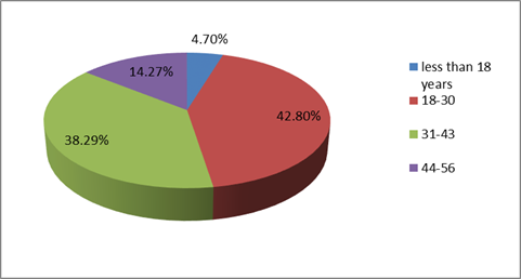
The results of sociological studies carried out within the framework of quantitative and qualitative methodology served the empirical basis of the study: a questionnaire survey of the residents of the Volga Federal District, West Kazakhstan Province conducted via social media site (sampling population made 578 respondents). The analysis of the sociological study showed that the population aged 18–43 was the most active as the age groups with the most active users of social media sites (Figure
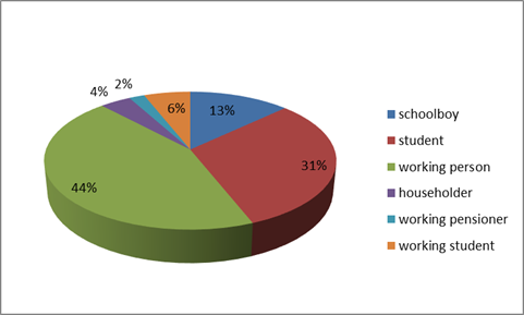
The main participants of the survey were working citizens and students (Figure
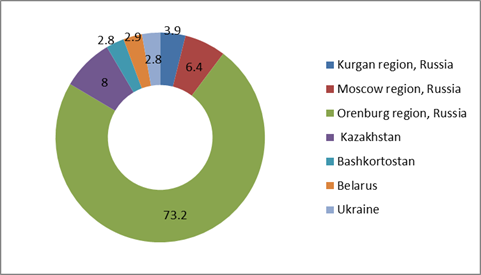
The geography of respondents covers cross-border regions of Russia and Kazakhstan (Figure
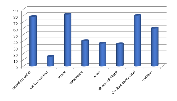
To the question “List your associations with Orenburg Region”, the majority of answers are presented in the diagram (Figure
The image of Orenburg Region connected with the Salt Lake Razval in Sol-Iletsk can be traced among all respondents from Kazakhstan, which can be explained by the geographical position of the resort lake, proximity to the border with Kazakhstan. The respondents from other regions did not mention this object.
Conclusion
The image of the region is formed on the basis of territorial identity, systemically expressed in bright, attractive, value characteristics of the territory. These are visual, verbal and virtual objects, events, processes and phenomena, symbols, “brand” features by which consumers identify the region.
The image of the territory is understood on the basis of the chorological principle – geographical characteristic of regions with identification of peculiar, distinctive, unique features forming regional identity.
The image of the region is a set of not only emotional, but also rational ideas resulting from a comparative analysis of all features of the territory, personal experience, rumors, judgements of prominent figures, various media.
The image of the region is inclusively formed by the whole set of elements of natural geosystems and socio-economic systems within “nature-population-economy” relations.
The structure of the image of the region consists of the main “core” image, on which additional images are applied.
In our view, the main factors forming and producing the image of the region are the natural components of the territory as the most stable components of regional space. Thus, the image of the regions of North Kazakhstan, Orenburg and Rostov Region of Russia is associated with the steppe space, Kabardino-Balkaria as a republic of mountain landscapes, Kamchatka as an area of volcanoes and geysers. Another feature defining the image of the region is organically established softly formed regional brands (Orenburg shawl, Vologda oil, Astrakhan watermelons), as well as internationally recognized architectural objects and structures (Moscow and Kazan Kremlin, Winter Palace and Peter and Paul Fortress, Mother Motherland Statue).
It is very important to present and promote the core elements of the image components in the information space. It is usually the most appealing technique, first of all, due to its impact on emotional-sensual perception of information by most consumers (folklore, cinema, music, songs with regional content).
References
- Animitsa, E. G., & Vlasova, N. Yu. (2016). Evolution and the main components of the image of the Urals. Geograph. Bull., 3(38), 28–35.
- Berger, P., & Lukman T. (1995). The Social construction of reality. Treatise on the sociology of knowledge. Medium.
- Berlant, A.M. (1996). Geo-economics. Astrea.
- Chesnokova, O., & Purves, R. S. (2018). From image descriptions to perceived sounds and sources in landscape: Analyzing aural experience through text. Appl. Geography, 93, 103–111. https://www.sciencedirect.com/science/article/pii/S0143622817313322?via%3Dihub#!
- Davis, W. M. (1924). The explanatory description of land forms. Leipzig.
- Derungs, C., & Purves, R. S. (2016). Characterizing landscape variation through spatial folksonomies. Appl. Geography, 75, 60–70. http://refhub.elsevier.com/S0143-6228(17)31332-2/sref7
- Farmaki, A., Khalilzadeh, J., & Altinay, L. (2019). Travel motivation and demotivation within politically unstable nations. Tourism Managem. Perspect., 29, 118–130. https://www.sciencedirect.com/science/article/abs/pii/S221197361830103X
- Fedotova, O., Latun, V., & Okuneva, I. (2014). Visual image of the continent in Russian textbooks on geography (1825–2013). Procedia – Social and Behavioral Sciences, 141, 731–737.
- Gettner, A. (1930). Geography: its history, nature and methods of the Department. State publ. house.
- Gold, J. R. (2009). Behavioral Geography. International Encyclopedia of Human Geography. https://www.sciencedirect.com/science/article/pii/B9780080449104006659
- Golub, A. B., (2012). Geographical culture-the image of the territory-the image of the region. Bulletin of the Amur State University. Sholem Aleichem, 2(11), 17–24.
- Gomez, Jr. (2017). The size of cities: A synthesis of multi-disciplinary perspectives on the global megalopolis. Progress in Planning, 116, 1–29.
- Heidegger, M. (1993). Letter of Humanism. Time and Being: Articles and speeches. Republic.
- Jenkins, A., Croitoru, A., Crooks, A. T., & Stefanidis, A. (2016). Crowdsourcing a collective sense of place. PLoS One, 11(4), e0152932. http://refhub.elsevier.com/S0143-6228(17)31332-2/sref12
- Kolosov, V. A. (2008). Geographical images and geopolitical representations: ways of formation and approaches to study. Bull. of DVGSGA. 1. The humanities, 1, 72–91.
- Lappo, G. M., & Honsch, F. W. (2000). Urbanization in Russia. Borntraeger.
- Levin, N., Mark, A., & Brown, G. (2017). An evaluation of crowdsourced information for assessing the importance of protected areas. Appl. Geography, 79, 115–126. http://refhub.elsevier.com/S0143-6228(17)31332-2/sref17
- Luhmann, N. (2005). The reality of the mass media. Praxis.
- Maksakovsky, V.P. (1998). Geographical culture. VLADOS.
- Mansfeld, Y. (1992). From motivation to actual travel. Annals of Tourism Res., 19(3), 399–419. https://www.sciencedirect.com/science/article/abs/pii/016073839290127B
- Miroshnichenko, I. V. (2018). The spatial image of Europe in the ideas of Russian youth: the results of an empirical study. Bull. of Perm Univer. Polit. Sci., 2, 31–44.
- O'Loughlin, J., Raento, P., Sidaway, J. D., Sharp, J., & Steinberg, P. E. (2013). Political Geography in the age of electronic information. Polit. Geography, 32, 1–2. https://www.sciencedirect.com/science/article/pii/S0962629812001424?via%3Dihub
- Pankrukhin, A. P. (2008). The image of the territory, its brand and counter marketing. In Image 2008: Image as an instrument of attractiveness and competitiveness (pp. 119–133). RIC AIM.
- Penck, W. (1924). The morphological analise A chapter of physical geology. Stuttgart.
- Plato (1578). Dialogues. Parmenides or on ideas. http://ancientrome.ru/antlitr/ t.htm?a=1450240000
- Pudup, M. B. (2001). Region: Geographical. In International Encyclopedia of the Social & Behavioral Sciences (pp. 12905–12908). https://www.sciencedirect.com/science/article/pii/ B008043076702475X?via%3Dihub
- Quercia, D., & Schifanella, R. (2015). Smelly Maps: The digital life of urban smellscapes. In 9th international AAAI conference on web and social media. http://refhub.elsevier.com/S0143-6228(17)31332-2/sref29
- Rassadina, T. A. (2015). The image of the region: aspects of the formation and assessment of the population (on the example of the Ulyanovsk region). News of higher ed. Institute. Volga region. Soc. Sci., 4(36), 163–178.
- Roth, K. (2007). What`s in Region? Southern European regions between globalization, EU-integration and marginalization. Ethnolog. Balcan., 11, 17–42.
- Sack, R. D. (1986). Human territoriality. Its theory and history. Cambridge.
- Shills, R. (1991). Places on the Margin. Alternative Geographies of Modernity. Routledge.
- Suttie, D., & Hussein, K. (2016). Territorial Approaches, Rural-urban linkages and inclusive rural transformation. In Global Policy Engagement Forum and Technical Meeting. IFAD.
- Thrower, N. I. W. (1972). Maps and man: An examination of cartography in relation to culture and civilization. Englewood Cliffs.
- Toal, G. (Gearóid Ó Tuathail) (2018). Muted impact: Is political geography still a backwater? Polit. Geography. Elsevier Ltd., 65, 152–153.
- Tuan, Y.-F. (1997). Space and Place: The perspective of experience. E Arnold.
- van Zanten, B. T., van Berkel, D. B., Meetemeyer, R. K., Smith, J. W., Tieskens, K. F., & Verburg, P. H. (2016). Continental scale quantification of landscape values using social media data. Proceed. of the National Acad. of Sci., 1–7. http://refhub.elsevier.com/S0143-6228(17)31332-2/sref36
- Vazhenin, S. G., Vazhenina, I. S., & Sukhikh, V. V. (2012). The image of space in the context of economic development of the territory. Reg. Econ., 31, 2–7.
- Vazhenina, I. S. (2010). Image and reputation of the territory. Regi. Econ.: Theory and Pract., 23(158), 2–12.
- Verlen, B. (2001) Society, Action and Space. Alternative social geography. Sociolog. Rev., 2(1), 25–46.
- Vernadsky, V.I. (1991). Scientific thought as a planetary phenomenon. Nauka.
- Yakovlev, M. (2011). Political image of the region in modern Russia. MAX press.
- Zamyatin, D. N. (2003a). Geographical images: what is It? Geography in school, 6, 21–29.
- Zamyatin, D. N. (2003b). Humanitarian geography: space and language of geographical images. Alethea.
- Zamyatin, D. N. (2006). Culture and space. Modeling of geographical images. Znak.
- Zamyatin, D. N. (2013). Geocultural branding of territories: conceptual foundations. Labyrinth. J. of Soc. and Human. Studies, 5, 11–23.
- Zolina, G. D. (2007). The Formation of a positive image of the Krasnodar region in the media (Doctoral Dissertation). Krasnodar.
Copyright information

This work is licensed under a Creative Commons Attribution-NonCommercial-NoDerivatives 4.0 International License.
About this article
Publication Date
31 October 2020
Article Doi
eBook ISBN
978-1-80296-091-4
Publisher
European Publisher
Volume
92
Print ISBN (optional)
-
Edition Number
1st Edition
Pages
1-3929
Subjects
Sociolinguistics, linguistics, semantics, discourse analysis, translation, interpretation
Cite this article as:
Ivanisheva, N., Semenov, E., & Popova, O. (2020). Image Of The Region: Explication Of Conceptual-Theoretical Representations. In D. K. Bataev (Ed.), Social and Cultural Transformations in the Context of Modern Globalism» Dedicated to the 80th Anniversary of Turkayev Hassan Vakhitovich, vol 92. European Proceedings of Social and Behavioural Sciences (pp. 1922-1933). European Publisher. https://doi.org/10.15405/epsbs.2020.10.05.254