
State Activities Impacts on the Residential Mobility Dynamics in Kandy and Suburbs


Abstract
Residential mobility is becoming a significant phenomenon in the contemporary urbanized world. City residents engage in mobility, which influences the shaping and reshaping of urban spaces. Residential mobility takes place due to several determinants, and urban development activities of the state are one of the significant structural factors among them. Kandy is the second-largest city in Sri Lanka which has been declared as a World Heritage City in 1988 by the UN. The Government of Sri Lanka has implemented urban policies, regional and city plans, urban development programmes, and strategic projects to preserve the unique urban characteristics of Kandy city. The objective is to assess how far state activities are responsible for the present residential mobility dynamics in Kandy city and its suburbs. The attributes of urbanisation and resultant neighbourhood changes discovered from the study conducted between 2016 -2018, by collecting secondary data from relevant sources. Primary data which was acquired through in-depth interviews, key informant interviews, unstructured discussions and observations comprises a part of the study. The study resulted in identifying the dynamics of an urban neighbourhood and its residential mobility changes. State activities are directly and indirectly stimulating the urban residential mobility diffusion waves towards Kundasale suburb that promote Kundasale as a popular residential suburb of Kandy city. The process, prospects, and products of urbanisation and residential mobility are discussed in detail in this paper.
Keywords: Residential mobilityurban developmentstate activitiessuburbsmobility diffusion waves
Introduction
Managing cities and their growth globally is one of the most significant challenges of the twenty-first century. The world’s population existing in urban spaces were 55 % in 2018, and the percentage is expected to increase to 68% by 2050
Significant of the study
As the world continues to urbanize, urban sustainability depends increasingly on the successful management of urban growth, urban development, and civic planning activities (Department of Economic and Social Affairs, 2018). This study contributes to the discourse of residential mobility literature by supporting theoretical contribution and practical urban development and planning activities. In Kandy city, there is a conflict of ideas between the conservation of heritage and promotion of modernity. Recent modernization of the Kandy town and unplanned development had caused overcrowded conditions in historical heritage areas. The results are evident in heavy traffic congestion and urbanization encroaching into land towards disaster vulnerable areas (Japan International Cooperation Agency, 2018). In 2016, the Government of Sri Lanka (GOS) requested the Government of Japan (GOJ) to implement the Project for Formulation of Greater Kandy Urban Plan (GKUP). Under the above circumstances, this study explores the “Impact of state activities on residential mobility in Kandy city and its suburbs in Sri Lanka.”
Defining urban residential mobility
Urban residential mobility constitutes the movement of the urban household from one residence to another. Hedman (2011) defined residential mobility as short-distance moves within a local housing market often with-in a city. Residential movement of the household within the 10km residual from the city centre and 2km residual from each centre of the suburbs are considered as ‘urban residential mobility’ in this study. According to Brown and Moore (1970) model, the state's activities (urban development) exhibit significant stress factors in terms of residential mobility. Residential mobility will take place when housing needs and expectation of the inmates match with housing opportunities available in the urban environment, which are influenced by several determinants (Knox & Pinch, 2014). Residential mobility can be a voluntary (choice) or involuntary (force) action in an urban environment. Some inmates move their residence by their choice; however, due to urban development activities/government policies, some are forcedly evicted from their residence.
State and urban residential mobility
The state has the authority and abilities to make the decisions and have the capacity to enforce them. According to the existing literature, intellectuals have explored that the national state power, policy formation, and socio-political struggle are needs that respond both globally and nationally (Brenner, 2004). Sánchez and Andrews (2011) analysed the pattern of residential mobility among 36 member countries of the Organization for Economic Co-operation and Development (OECD), and they found that differences in residential mobility across countries are partially related to differences in state public policies and due to differences in government interventions in urban areas. Nation-State factors play an essential role in shaping urban governance (Pierre, 1999). Cities with the same national context differ significantly concerning the degree of inclusion of related interests in urban governance, which, in turn, is reflected in urban policy outcomes (Pierre, 1999). Welfare governance reflects its particular type of urban political and economic setting, and these cities have minimal growth in the local economy (Pierre, 1999). Welfare governance combines mass political involvement with a hostile perspective on private businesses that are believed to be the cause of the city’s plight. Although Sri Lanka is following the welfare urban governance model from its independence, the degree of welfare programmes has reduced since the introduction of its open economy policy from 1977 (Peiris, 2012). However, Sri Lanka still maintains the critical pillars of welfare state qualities with the admission of the capitalist economy.
Problem Statement
City residents engage in mobility inside the city, and those mobility patterns influence the structure of urban areas
The number of urban studies, particularly on residential mobility utilized the structural connections. However, these structural connections have hardly ever been theorized in any discernible way
Monitoring, planning, and controlling residential mobility and neighbourhood areas are essential for the sustainability of urban spaces.
Most studies conducted on residential mobility and state policies in Sri Lanka focus on the capital city of Colombo. Studies focus on housing for metropolitan poor and rich, social mobility, class formation and housing market, urban housing policy in Sri Lanka
This study intentions to understand the impact of state activities on urban residential mobility in Kandy city and its suburbs of Sri Lanka by applying the structuration theory as an analytical tool. At the end of this study, some theoretical experiment is expected to incorporate, and a new model of state involvement and residential movement is attempted to be proposed.
Research Questions
Research questions
Three specific research questions were developed to understand the above research problem in this study.
How is population change an indicator of residential mobility?
What are the urban development activities, policies, and plans have been implemented during the last three decades in Kandy city?
To what extent state activities influence peoples’ preferences in terms of residential mobility decision?
Theoretical, conceptual and analytical framework
The above research questions developed under the specific theoretical, conceptual and analytical framework. Anthony Giddens proposed the theory of structuration in 1984. According to Giddens (1984), 'Agency' is the capacity of individuals to act independently and to make their own free choices and 'Structures' are patterned social arrangements that affect the agency. He specifies that structure and agency cannot be separated and they connected by the "duality of structure." Structuration theory addresses the way in that everyday social practices are structured across space and time. The structuration approach has become a significant influence in contemporary human geography, particularly in urban geography due to its socio-spatial dialectic (Knox & Pinch, 2014). This study accommodates structuration theory by focusing on:
Actors (peoples' residential internal motivations in urban space)
Structures (External forces in urban space, State is the structure in this study)
As society becomes more and more urban, Giddens's theory can provide great assistance to policymakers and human geographers to understand the needs of the current and future generations (Lamsal, 2012). This research was conducted in an urban space (Kandy) where housing decisions are taken by agents (People) by their own choices and/or by force to a considered decision based on the power relationship with state activities. So,
Purpose of the Study
Main objective
The general objective is to examine the influence of state activities on the residential mobility pattern in Kandy city and its suburbs.
Sub objectives
The following three sub-objectives were developed to achieve the above main objective:
Explore the linkages between population changes and residential mobility in Kandy city and surrounding areas
Find out urban development activities, policies and plans that have been implemented during the last three decades in Kandy city
Examine the impact of state activities on peoples’ preferences in terms of residential mobility patterns in the city of Kandy and its suburbs.
Research Methods
This study is a theoretical based empirical study which connects philosophical ideologies of
Research methods
The triangulation methodological design is used base on philosophical negotiation and scientific reasoning in this study. Primary data were collected from May 2018 to February 2019 through Key Informant Interviews (KII), In-depth interviews, unstructured discussions and observations. Mainly, eight KII were conducted with national and local urban bureaucrats. KII guides were prepared for each informant before going to the field. Based on the objectives, 23 in-depth interviews were conducted through purposive sampling techniques. Informal discussions were performed with the number of people in an unsystematic way, and they gave insightful knowledge about the urban development aspects of the study and helped to render the empirical evidence more concrete. Straight observation method was used in this study continuously for around ten months in the field with the help of the observation matrix. Secondary data sources were collected from various government and non-governmental institutions through web pages, annual reports, books, journals, magazines, local newspaper articles, past research documents and unpublished documents. The collected primary and secondary data were analysed through analytically descriptive methods.
In this research, qualitative data were analysed using descriptive, ranking and scoring methods. Based on those transcriptions, connections were traced related to residential mobility and state influence. Those connections were ranked and scored base on the significance. The limitations faced during the study were neutralized as much as possible. Qualitative data were transcribed very carefully without changing the participant feelings, words, emotions, and expression, in order to maintain the validity of the study. Informal interviews and discussions were carried in the local native language since they promoted a highly efficient level of understanding the interview participants. Data gathered through multiple qualitative methods increased the reliability of the result and findings.
Study area
Kandy is the second-largest city in Sri Lanka, and it is recognized as a sacred place of worship in the Buddhist world because of the Royal Palace along with Sri Dalada Maligawa (Temple of the Sacred Tooth Relic). Kandy city is connected with three cluster suburbs, namely Katugastota, Kundasale, and Peradeniya (see figure
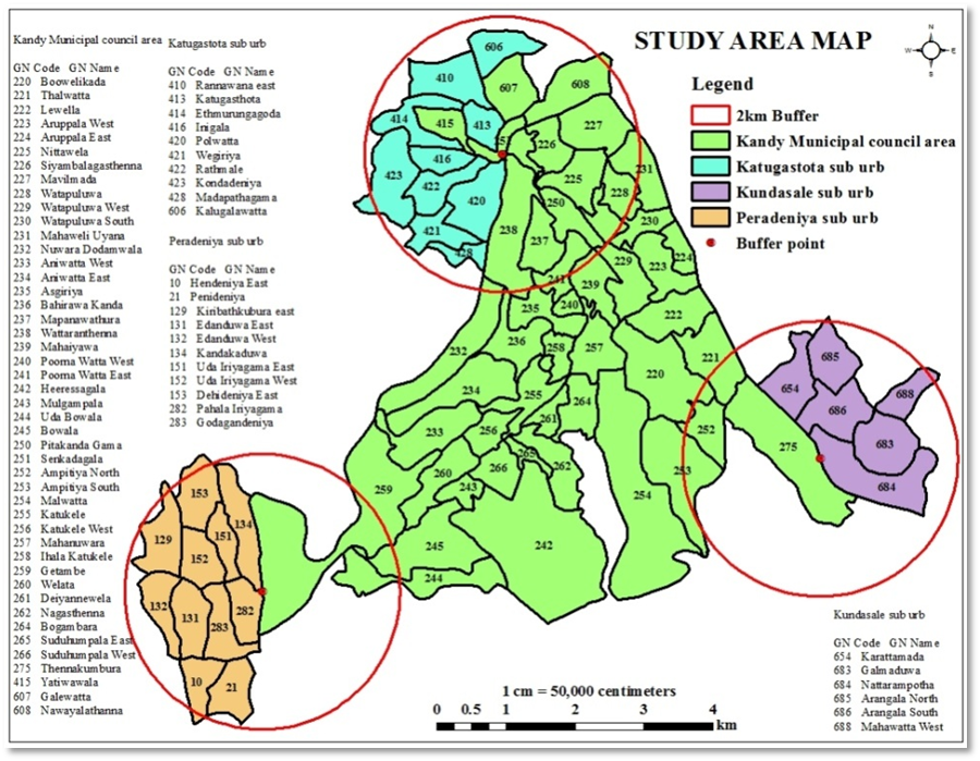
Source: Prepared based on the
Findings
Population changes and residential mobility
Population dynamics were observed in the Kandy Municipal Council (KMC) area and the surrounding nine Divisional Secretariat Divisions (D. S divisions) hint residential mobility in KMC and the adjacent regions. Figure
Densely populated area depicting decline trend ( recorded within the centre of the town)
Medium population areas with an increasing trend along with minor fluctuation (observed in Kundasale, Udunuwara, Yatinuwara, Harispattuwa, and Pathadumbara D.S areas)
Low population areas with a stable pattern (Pathahewaheta, Doluwa, Delthota)
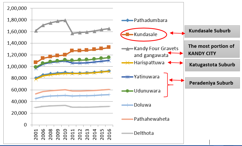
Source: Prepared base on Department of Census and Statistics, Sri Lanka, 2001, 2011) and District Statistical Handbook - Kandy, 2010 – 2019
However, Kundasale D.S Division shows a unique population trend with rapid increases of population than any other surrounding D.S Division of Kandy city (Figure
“Residential population is highly reducing in the city centre. The residential areas converted for commercial purposes in Kandy city, mainly for tourism activities including rest houses, hotels, guest houses, etc. and which also attribute to these population changes.”
(Strategic Town planner who has 12 years experiences in UDA, 2018)
Population density analysis explored the population increasing and decreasing areas in the city and its surrounding areas. High and medium population areas were accommodated for population density analysis due to the less influence of low population area (Doluwa, Pathehewaheta & Delthota, see Figure
Bodies of urban governance of Kandy city and Residential Mobility
The primary national-level governance of Kandy city is the National Physical Planning Departments (NPPD) and Ministry of Megapolis and Western Development. In the local level, the Urban Development Authority (UDA) is the responsible body to manage the urban areas, and UDA central province who is managing all the urban development activities of Kandy city. Besides this, several government agencies are partly supporting urban development efforts.
National Urban Development Policy regarding Kandy city
National Physical Planning Departments (NPPD) is authorized to formulate and implement the national physical plan for development purposes under the Town and Country Planning Ordinance No.13 of 1946 (Amendment No. 49 of 2000), in Sri Lanka.
“The Central Fragile Region” has been included in the Protected Area Network to establish its importance in conserving the water resources of the country. In this area, selected towns will continue to exist, but their development and expansion will be controlled and restricted.”
After the change of the government in 2016, NPP has been revised the target year from 2030 to 2050, and has put NPP under revision. The draft development plan proposes four urban corridors in Sri Lanka. Kandy city that is not directly included into any urban corridors, but it is close to ‘cross country urban corridor’ which is accessible by the national road (A10) through Galagedara and Kundasale from Kandy. State policies indirectly control the development of the Kandy city and its suburbs. So, The State National Physical Plan directly impacts the development process of Kandy city.
(General Director, UDA, Central Province, 2018)
Existing plans for Kandy urban development (local and regional)
Three existing development plans are significantly influenced by the urban development and residential mobility pattern of Kandy city and surrounding suburbs.
The UDA developed the Greater Kandy Development Plan 2020 by the Central province office in 2008 (Japan International Cooperation Agency, 2018). This plan was designed to overcome the urban issues-particularly congestion in the urbanized area and to protect the heritage areas. The main aim of this plan is to develop the Kandy town as a World Heritage town. This GKDP was implemented with an area of 273Km2 including eight surrounded Divisional Secretariat D.S.Divisions. Under this plan, the following urban facilities has been relocated to outside the Kandy city area ( see figure
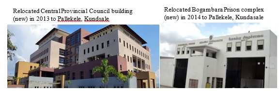
Source: Taken from the field, 2018
“Urban settlement pattern has already changed according to my observation…, and I think our previous urban development plans also influenced residential pattern….”
(Physical Planning officer who has twelve years’ experience at UDA, 2018)
Around 150 employees are working in the Central Provincial Council office, and some of them have now settled down in Kundasale. Some Bogambara Prison employees also reside around Kundasale after the relocation of the prison and quarters facilities. New developments also have taken place towards the Pallekele and Kundasale area. Some of them are given below:
Kandy Export Processing Zone, Pallekele, Kundasale: (after 1977)
International Cricket Stadium, Pallekele, Kundasale: (after 2009)
SIBA (Sri Lanka International Buddhist Academy) Campus located at Kundasale suburb (after 2009)
Domestic Airport Project, Kundasale (under process)
The following four different strategic plans were formulated to achieve the above goals, and has been implemented:
Urban corridor development: State identified two specific corridors for the future expansion of the city (see figure
4 ).Northwestern Corridor: Stretch from Pilimathalawa to Katugastota (via Peradeniya suburb, Kandy city centre, and Mahaiyawa) -
Eastern Corridor: Stretch from Tennekumbura to Digana (via Kundasale suburb, Pallekele, and Digana)
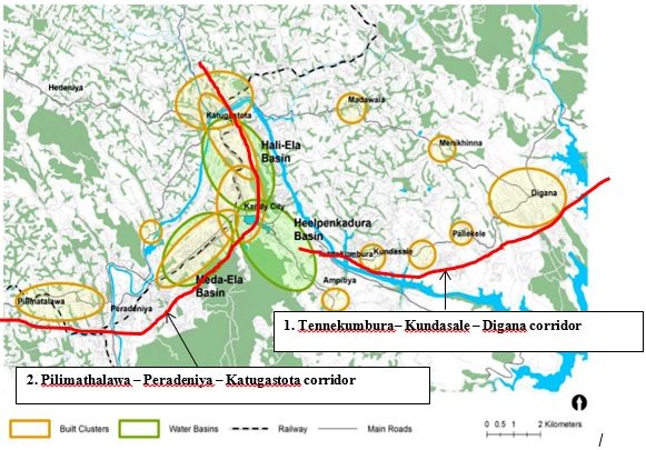
Source: Kandy City Region Strategic Development Plan, 2030 (Modified)
However, comparatively residential movement is evident towards Tennekumbura to Digana stretch than the Pilimathalawa to Katugastota stretch. Menikhinna – Pallekele road rehabilitation and expansion project have been completed now, and the residential corridor is in progress. Implementation of SCDP is also one of the main reasons for this unexpected housing agglomeration pattern in Kundasala area. A large number of block out areas such as Summerfield in Balagolla and Morakkapitiyawatte are becoming popular in Kundasale upper middle-class residential area. The following Table
“I came to Kundasale in 1990 under the ‘Gam Udawa’ housing programme (78 houses) during the Premadasa government. That time, 20 perch lands were given to retired police officers in Kundasale, and we build houses ourselves…. Now, I prefer to stay here because of higher accessibility, particularly 24 hours bus services…..”
(A resident of ‘Gam Udawa’ housing Scheme, 2018)
After the 1977 Board of Investment (BOI) established in Kundasale, that was the first initiative wave towards Kundasale suburb. The 2nd development phase started with ‘
-
Promote satellite growth centres: Based on the identified two urban corridors facilitate the development of satellite growth centres along with the strategic attraction are evident. The satellite centres are expected to promote attraction and growth in and around them with the development of major urban facilities.
Development of new urban hierarchy: A new hierarchy of services and employment centres are designed to achieve modest urban growth, to develop around the Kandy city. The main centres are promoted nearly equal to Kandy City Centre in terms of service provisions, shopping facilities, and employment opportunities for the residents in the region. The following table
“ More than other towns, Kundasale is becoming as the catchment area for the upcoming private and government housing projects…from our side we develop good infrastructure facilities including water supply, electricity, telecommunication, etc. with these climbers, the highest settlement waves move towards Kundasale, and higher waves also develop towards Katugastota town.”
(General Director, UDA, Central Province, 2018)
Promote confined population distribution: The residential population of Kandy city is predicted to increase to 600,000 in 2030 (Japan International Cooperation Agency, 2018) and the Kandy city region strategic development plan 2030 is proposed to distribute the population in the following manner around Kandy city region (see the table 3):
The UDA prepared the Greater Kandy Master Plan in January 2015 based on the existing the above two plans. This master plan identified four urban planning issues in Kandy city, which are: Urban sprawl and ribbon development that are out of control, traffic problems inside the city area, town identity issues related to world heritage characteristics and specific environmental problems. The five strategies are ideated in the master plan to overcome the above urban problems, and among that one strategy is densifying land use/housing: enable the development of new high – density housing along transit routes by improved rail corridor which is under the initial development stage.
The following ongoing urban development projects are also expected to influence on the future residential pattern of Kandy city and its suburbs.
Central Expressway Project by RDA (commenced in 2011): In future when the centra expressway project is completed Katugastota suburb will be developed faster and Katugastota – Kurunagela road will be a demanding location for residential purposes.
Double-track railway project: This project is implemented between Peradeniya to Kandy and its connect Peradeniya, Kandy, Katugastota, Digana, and Kundasale towns in the future and residential expansion can be expected along rail corridor.
South Bypass feasibility study project: If this is implemented in future, the outer circular ring road will be connected and promote residential expansion expected along the outer ring road.
The Kandy Multimodel Transport Terminal (KMTT) project target to start operations in 2020 and will support accesibility to expand residential patterns.
(Strategic Town planner who has 12 years experiences in UDA, 2018)
However development consistency is questionable regarding zoning plans when political changes take place.
(Physical Planning officer who has twelve years’ experience at UDA, 2018)
Comparatively, it is clear that the state is, directly and indirectly, motivating residential mobility towards the east corridor (Kundasale suburb) and along the southwest corridor (Katugasthota – Peradeniya connectivity). Katugastota identified as the sencond fast growing suburb following the Kundasale suburb. However, Peradeniya suburb is the least attracted residential suburb around the Kandy city.
“
(General Director, UDA, Central Province, 2018)
Conclusion
The study found that state urban activities have influenced residential mobility, and this has created a new urban spatial dynamics in Kandy. The following model explains the causal relationship between Structure (State), Agency (residence), Place and Residential mobility in the Kandy city and its suburbs (Figure

This study concludes that population change observed in Kandy city and its suburbs is an indicator of residential mobility patterns in the city and its surrounding areas. More economically empowered make their own choices on where they want to reside. This economic advantage indirectly mobilized them towards the suburbs, particularly in Kundasale. However, urban poor do not have those own choices, and when the state gave land, they were forced to mobilize towards those areas mostly in Kundasale. Comparatively, the highest residential mobility identified towards Kundasale suburbs. The national and local urban development policies, plans and projects which have been implemented in the recent past in Kandy city has been motivated the substantial mobility pattern towards specific urban spaces.
Acknowledgments
I am currently pursuing my PhD at the Department of Geography at Bangalore University. This is a part of my doctorate research under the Indian Commonwealth Scholarship 2016/2017 by the Indian Council for Cultural Relations (ICCR), India. This research was partly funded by the University Research Grant, University of Peradeniya (Grant no: URG/2018/12/A). I am grateful for the support of Bangalore University, ICCR and the University of Peradeniya.
References
- Brenner, N. (2004). New state spaces: Urban governance and the rescaling of statehood (1st ed.). Oxford University Press.
- Brown, L. A., & Moore, E. G. (1970). The intra-urban migration process: A perspective. GeografiskaAnnaler, Series B, 52(1), 1-13. https://doi.org/10.2307/490436
- Coulter, R., Ham, M. V., & Findlay, A. M. (2016). Re-thinking residential mobility: Linking lives through time and space. Progress in Human Geography, 40(3), 352–374. https://doi.org/10.1177/0309132515575417
- Coulton, C. J., Theodos, B., & Turner, M. A. (2009). Family mobility and neighborhood change: New evidence and implications for community initiatives. The Urban Institute: Annie E. Casey Foundation Making Connections Research Series (pp. 1–57). https://www.urban.org/sites/ default/files/publication/30711/411973-family-mobility-and neighborhood-change.pdf
- Department of Census and Statistics Sri Lanka. (2001). Census of population and housing report 2001. http://www.statistics.gov.lk/page.asp?page=Population and Housing
- Department of Census and Statistics Sri Lanka. (2011). Census of population and housing report 2011. http://www.statistics.gov.lk/page.asp?page=Population and Housing
- Department of Economic and Social Affairs. (2018). Sustainable development goals UNDESA 2018. https://www.un.org/sustainabledevelopment/blog/2018/05/68-of-the-world-population-projected-to-live-in-urban-areas-by-2050-says-un/n.
- District Statistical Handbooks - Kandy (from 2000 to 2017). Colombo. http://www.statistics.gov.lk/DistrictStatHBook.asp?District=Kandy&Year=2010.
- Fattah, H. A., Salleh, A. G., Badarulzaman, N., & Ali, K. H. (2015). Factors affecting residential mobility among households in Penang, Malaysia. Procedia - Social and Behavioral Sciences, 170, 516 -526. https://doi.org/10.1016/j.sbspro.2015.01.077
- Giddens, A. (1984). The constitution of society: Outline of the theory of Structuration. Review by M. D. Zamora, Man, 20(3), 567-568. Polity Press. https://doi.org/10.2307/2802469
- Ham, M. V., & Clark, W. A. V. (2009). Neighbourhood mobility in context: Household moves and changing neighbourhoods in the Netherlands. Environment and Planning A, 41(6), 1442–1459. https://doi.org/10.1068/a4182
- Hedman, L. (2011). The impact of residential mobility on measurements of neighbourhood effects. Housing Studies, 26(4), 501–519. https://doi.org/10.1080/02673037.2011.559753
- Japan International Cooperation Agency. (2018). GKUP report: Project for the formulation of Greater Kandy urban plan, (GKUP). https://openjicareport.jica.go.jp/pdf/12320222.pdf.
- Knox, P., & Pinch, S. (2014). Urban social geography, An introduction. Routledge. https://doi.org/10.4324/9781315847238
- Lamsal, M. (2012). The Structuration approach of Anthony Giddens. Himalayan Journal of Sociology and Anthropology, 5, 111-122. https://doi.org/10.3126/hjsa.v5i0.7043
- National Physical Planning Department. (2010). National physical planning policy and plan - 2030. Colombo, Sri Lanka. https://www.academia.edu/32076252/National_Physical _Planning_Policy_ and_Plan_Sri_Lanka_2030_National_Physical_Planning_Department
- Niriella, C. N. (2010). Ethnic strife and urban neighbourhood ties: Lessons learnt from low-income dwellers in Colombo, Sri Lanka. VDM Verlag Dr. Muller.
- Niriella, C. N. (2016). Housing for metropolitan poor and rich in Sri Lanka : Emerging features research. International Journal of the Social Research Foundation, 4, 11–21.
- Pacione, M. (2005). Residential differentiation and communities in the city (2nd ed.). Urban geography: A global perspective. Routledge Taylor & Francis Group. https://doi.org/10.4324/9780203454626_chapter_18
- Peiris, G. H. (2012). Challenges of the new millennium. Kandy Books.
- Pierre, J. (1999). Models of urban governance: The institutional dimension of urban politics. Urban Affairs Review, 34(3), 372–396. https://doi.org/10.1177/10780879922183988
- Sánchez, A. C., & Andrews, D. (2011). Residential mobility and public policy in OECD countries. OECD Journal: Economic Studies, 2011(1), 185–206. http://www.oecd.org/ economy/growth/residential %20mobility%20and%20public%20policy.pdf
- Sharkey, P. (2016). Neighborhoods, cities, and economic mobility. The Russell Sage Foundation Journal of the Social Sciences, Opportunity, Mobility, and Increased Inequality, 2(2), 159-177. https://doi.org/10.7758/rsf.2016.2.2.07
- Short, J. R. (1978). Residential mobility. Progress in Human Geography, 2(3), 419–447. https://doi.org/10.1177/030913257800200302
- SriLanka Survey Department. (2018). Maps and geo information. https://www.survey.gov.lk/sdweb/home.php
- Uni Consultancy Services. (2015). Kandy city region strategic development plan - 2030. https://www.scdp.lk/kandy_city
- United Nations. (2018). World urbanization prospects: The 2018 revision, United Nations economic & social affairs. https://population.un.org/wup/
Copyright information

This work is licensed under a Creative Commons Attribution-NonCommercial-NoDerivatives 4.0 International License.
About this article
Publication Date
12 October 2020
Article Doi
eBook ISBN
978-1-80296-088-4
Publisher
European Publisher
Volume
89
Print ISBN (optional)
-
Edition Number
1st Edition
Pages
1-796
Subjects
Business, innovation, sustainability, environment, green business, environmental issues, urban planning, municipal planning, disasters, social impact of disasters
Cite this article as:
Balakrishnan, A., Hanjagi, A. D., & Narayanan, P. (2020). State Activities Impacts on the Residential Mobility Dynamics in Kandy and Suburbs. In N. Samat, J. Sulong, M. Pourya Asl, P. Keikhosrokiani, Y. Azam, & S. T. K. Leng (Eds.), Innovation and Transformation in Humanities for a Sustainable Tomorrow, vol 89. European Proceedings of Social and Behavioural Sciences (pp. 37-52). European Publisher. https://doi.org/10.15405/epsbs.2020.10.02.4