
Improving Pedestrian Walkway Through Local Activity-Based Guidelines


Abstract
The emergence of on-demand mobility services in developing countries forces local governments to not only create better regulations to accommodate, but also to provide better public transportation. These contributed to the increase of pedestrians and opened a new era of users to the aging sidewalk and its facilities, thus needing improvements and raising the question of whether the existing pedestrian environment in the cities is ready to accommodate these new behaviors. As one of the leading Indonesian cities for pedestrians, Bandung City holds an integral part in shaping Indonesian people's perception of urban walkability. However, in a detailed planning perspective, there is not yet available a detailed guideline about pedestrian facility design. This paper is trying to explore how the characteristics of the supported area' activity and environment affect pedestrian service quality needed, and how to improve the guideline for planning, monitoring, and evaluating future facilities with Bandung City Square as the case study. Through field observation, a user evaluation questionnaire, and importance-performance analysis, the result showed that as a whole area, the city square classified as having excellent performance and high importance for users. Nevertheless, there are some aspects of pedestrian behavior that have not been supported, mainly regarding the integration with Mobility-as-a-Service. As the aspects of urban mobility are evolving, the efforts to support and control it also must keep up with it. Furthermore, as the urban transportation trend is concentrating more and more towards people, the adjacent facilities will become an essential role in defining how cities operate.
Keywords: Walkabilitypedestrian serviceurban activity
Introduction
The rapid growth of global urbanization has shifted the urban-rural population spread worldwide. In the 50s, 29.6 percent of people are living in urban areas. That number has almost doubled to 53.9 percent in 2015 and will continue to rise until reaching 68.4 percent in 2050 (United Nations, 2018). Cities are becoming the beacon of economic growth that expanding rapidly, and as one of the leading global economic centers, Asian Cities have been experiencing rapid urbanization within the last 30 years. As the population increase, the increase in public transportation needs is also experiencing growth over the last three decades. Between 1980-2000, the number of vehicles per 1000 people in Seoul went tenfold while Bangkok's rose from under 50 vehicles to over 300 (Hayashi et al., 2004). This increase also caused the rise of urban transport problems, especially related to the high traffic jam rate and decreasing environment quality.
Indonesia, since the early 2000s, had realized the lingering effect of high urbanization rate in the form of urban transportation problems. The 1997 Asian financial crisis further deteriorated the transport investment rate, reaching only 3.5% of GDP, more than half less than 8% in the previous year (Leung, 2016). The first one is terrible traffic congestions that once famously ranked as one of the worst in the world, according to Toppa (2015) and TomTom Traffic Index (2019). The second is an outdated urban transport service that relies on private providers that riddled with long waiting times, disregard of passenger safety, and an unreliable trip schedule. These problems became the few bad images of Indonesia's big cities, the most prominent being Jakarta and Surabaya. At this point, most Indonesian knew that there had to be some exceptional approach to tackle these problems.
The launching of Transjakarta in 2004 became a starting point of mass urban transport rise in Indonesia and has continued to become a primary focus, especially in metropolitan cities. With Jakarta pioneering, Indonesia began searching their new public transportation identity. Both national and city governments started a longstanding initiative to revamp their public transportation service, and the system drives the big cities to adopt a more integrated system to provide transportation services for their citizens. Jakarta boasted the longest Bus Rapid Transit (BRT) system length in the world with (206.75 km) and has just opened the new Mass Rapid Transit as MRT Jakarta subway system and is currently preparing to activate its Light Rail Transit (LRT) that covers the outer ring areas. Surabaya launched its own BRT service in 2018 called Suroboyo Bus that currently operating in two routes, but more routes are coming shortly. The Ministry of Transportation is preparing to kickstarts more BRT development in 23 cities in the future and investing heavily in improving nationwide public transportation services.
At the same time, the emergence of Mobility-as-a-Service or MaaS has to shape the new era of urban transportation planning and policy. In the case of many cities, ride-sharing started to be a substitute for the traditional taxicab services in intra-city public transportation (Çetin, 2017). Furthermore, people would prefer to choose car-sharing mostly to reduce costs, prevent traffic congestion, meet new people (Lerro, 2015). In Helsinki, the residents can use an app called Whim for planning and payment of all public transport modes since 2016. Paris, Eindhoven, Hannover, LA, and Barcelona are only a few cities that have applied the MaaS from the peer-to-peer offerings to integrated public transportation scale that include private sector stakeholders/provider (Goodall et al., 2017). A key success factor of MaaS is to use a single account to pay all transport services, where users of MaaS does not need to have different cards or special payments (Li & Voege, 2017). In Indonesia, the rise of MaaS manifested in the form of motorcycle taxis and ride-sharing apps. One of the service providers, Gojek, is regarded as one of the most used apps among the e-commerce categories (Alvara, 2019). The presence of online ojeks is triggered by the reaction from various walks of life who rely on life with ojek service (Romli et al., 2018). These online ojeks also have unique characteristics, which is the synthesis of conventional transportation methods with innovative electronic transaction methods (Mustaqima et al., 2018). These online ojeks quickly became the household staple for almost every major city in Indonesia, thanks to the high penetration throughout the country, and the convenience provided.
The improvement of urban public transportation and the flexibility of MaaS in providing peer-to-peer mobility encourages urban citizens to walk more. This trend pushes the city governments to improve the quality of pedestrian ways provided to encourage people further and accommodate this new generation of pedestrians. As a country that ranked last in average steps taken (Althoff et al., 2017), the measures taken to revamp the sidewalks have been promising. Jakarta is currently having a significant sidewalk makeover to facilitate the new MRT lines, especially in the corridor of Sudirman – Thamrin Road and expands to Cikini, Senen, Kemang, and Jl. Prof. Dr. Satrio (The Jakarta Post, 2019). Surabaya is widening the pedestrian way in Yos Sudarso Street, complying with the citywide sidewalk revamp that puts Surabaya as one of the emerging walking cities in Indonesia. As the quality of sidewalks and pedestrian ways are improving, the synergy with the MaaS and integrated public transportation will open the new era of urban transport and mobility throughout Indonesian cities and towards a better future.
Problem Statement
As one of the earliest cities with a better pedestrian-friendly image, Bandung, as a city with a high number of tourism-based activities, relies heavily on its pedestrian facilities. Since 2013, Bandung has experienced a citywide sidewalk makeover to not only improve the service of its sidewalks but also to further accentuate the image of Bandung itself as a beautiful tourism city. At the same time, the needs and habits of pedestrians have evolved with the arrival of MaaS and the newer public transport system. ERTICO (2019) stated that in the making the MaaS Ecosystem, several actors from both within and outside of the transport sector should cooperate to offer MaaS, including the city governments, transport authorities, and infrastructure managers. Cities must also be evolving to adapt to these new urban activities. For this purpose, it is essential to explore whether the upgrade had taken the local characteristics and activities into account.
Research Questions
To further improve the pedestrian facilities, local city governments has been implementing the various approach in creating a pedestrian-friendly neighborhood. In Semarang City, the government recreates one of their heritage sites housing old European-style buildings to resemble an authentic colonial period neighborhood to give a more immersive experience for residents and tourists. Nevertheless, this effort has gained a few critics, mainly concerning the disregard of tropical walking conditions and the tendency to favor beauty over convenience. Those critics prompted the question of whether the current pedestrian facility design meets the needs of current users? Are the characters of local activities have been considered and accommodated within the design? How could we improve the facilities to be more integrated with the local MaaS?
Purpose of the Study
This study aims to understand how the character of Bandung' local urban activities could be accommodated within the pedestrian facility design to create a better and more integrated walking environment for the current users
Research Methods
This paper is aiming to explore the local activity characteristics affects pedestrian service quality needed, and how to improve the guideline for future pedestrian walkway using the exploratory approach. This paper uses a qualitative research approach, where the findings of this paper come from observation with a tool of pre-determined variables. Observation is a purposeful, systematic, and selective way of watching and listening to an interaction or phenomenon as it takes place (Kumar, 2011). The pre-determined variables provided the observation tool or indicators for this study. These variables were extracted from various preceding studies about walkability by using content analysis. The content analysis used to examine what factors need to consider in the provision of pedestrian infrastructure, where this analysis produced 25 indicators that used as an observation tool.
Furthermore, checklist analysis also used to compare existing conditions obtained from observations made previously with the pre-determined variables for pedestrian walkway provision. The conducted field observation targeted to the main pedestrian facilities inside the Bandung City Square area, which is one of the most populated pedestrian ways in the city. The area also functions as an extension of the central business district, while also designated as an essential heritage tourism site in Bandung City. A questionnaire survey conducted on 100 samples regarding their opinions on the pedestrian facility provided. This analysis aimed to identify the information about how much the current pedestrian walkway provision accommodate people, and anything that is still lacking within the provision in order to improve pedestrian walkway.
Findings
Introductions on Bandung Tourism
Bandung is known as one of the leading tourist destinations in the province of West Java, and even nationally. The development of Bandung tourism supported by many attractions, such as knowledge, history, culture, culinary, shopping, et cetera. Within the national scope, since 2011, Bandung has been designated as one of the National Tourism Development Areas and the National Strategic Tourism Area. Bandung is also a part of the National Tourism Destinations (Bandung-Ciwidey and surroundings). Bandung was crowned as the capital of Asia and Africa in April by 2015 Asian-African conference delegates because it has a long history of inspiring Asian-African countries to gain independence and recognition from the outside world.
Bandung was formerly known as 'Paris van Java' because its urban landscape beauty influenced by European culture and city designs. Also, Bandung is known as a shopping city, with shopping malls and factory outlets widely spread across the city and is now gradually becoming a culinary tourism city. In 2007, a consortium of several international NGOs made Bandung the pilot project of the most creative city in East Asia. Bandung's Regional Regulation No. 1 of 2013 on the Regional Tourism Development Master Plan for 2012-2025 regulates the tourism plan in Bandung. The regulation explained Bandung Government's plan to develop a regional tourism strategic area, which includes the natural eco-tourism area of North Dago, the educational and historical tourism area of Ganesha-Gedung Sate, the shopping and creative culinary tourism area of Jalan L.L.R.E. Martadinata, the cultural heritage tourism area of Braga Square, Ujungberung traditional cultural tourism area, and the Gedebage convention and sports tourism area.
Bandung is known as a region or area in the highlands surrounded by mountains, making it an area that has relatively cold temperatures, such as in the natural tourist area of Lembang. That is why tourists outside the area, especially Jabodetabek metropolitan residents, regard Bandung as a quick escape to spend a pleasant weekend. Moreover, it is easy to access Bandung with the existence of the Cipularang highway connecting Bandung with Jabodetabek. For tourists who come from outside Jabodetabek, it is still easy to go to Bandung because it supported by a variety of transportation facilities, such as trains, planes, and even inter-city buses.
The behavior of Online Ojeks, emerging User/Driver needs and its corresponding indicators
Online ojek services in Bandung currently provided by two companies: Gojek and Grab. Both companies based their services around the image of 'ease of mobility' by combining the ability to call a ride to pick up passengers from any origin point to drive them directly to the destination with a cashless payment that use a prepaid account balance that quickly purchased or "
In using this form of MaaS, four critical periods produce unique needs of supporting facilities:
Requirements, Descriptions, and Indicators of Pedestrian Walkway Provision in Urban Tourism Area
In order to design a detailed guideline about the pedestrian facility, this paper use indicator values based on the requirements from Indonesia's Ministry of Public Works and Public Housing, i.e., accessibility, safety, convenience, attractiveness, easiness, and social interactions. These requirements later rearranged and detailed into various indicators, where these descriptions of detailed indicators extracted from various preceding studies about walkability and presented through Table
By analyzing questionnaire results using Importance-Performance Analysis, a scatter plot diagram showing positions of each indicator in Figure
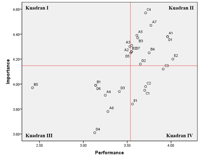
The indicators included in this quadrant are indicators that need the most improvement because these indicators have relatively low performance despite having a high level of importance to the walking environment. The indicator included in this quadrant is only 1, which is "Availability of boundaries/separators of pedestrian paths with motorized vehicles " (A2). Even so, other indicators lie in the boundary line between quadrants I and II, although they have a slight tendency towards quadrant II, namely the indicator "Signage is located in a strategic place so that it is easily visible" (D5). It means for this indicator still needs a little improvement in order to have better performance so that it can support the walking environment, following the high level of importance.
The indicators in the second quadrant are those that are good enough because they have a high level of importance accompanied by a good performance score, which means these indicators have met pedestrian expectations. The following are some of the factors included in quadrant II, namely:
Cleanliness of pedestrian infrastructure
Availability of lighting along the sidewalk
Availability of traffic lights and traffic signs
Availability of pavement for the pedestrian walkway
The surface of pedestrian facilities is flat, dry, non-slippery, wide enough, as small as possible
Conflict-free between pedestrians and other modes of transportation
Guiding block availability
Availability of benches for breaks, food/beverage kiosks
Pedestrian walkways can be an attraction for tourism activities
Pedestrian walkways provide the closest route
Signages located in a strategic place, so it is easily visible
Some of the added facilities needed for MaaS support are in this quadrant, mainly regarding the security needs in Phase 1 (Availability of lighting along the sidewalk, Availability of benches). Out of the eleven indicators included in quadrant II, two indicators tend to have lower performance than the others, so those located very close to the borderline between quadrants I and II, namely the indicator "Conflict-free between pedestrians with other modes of transportation" and "Guiding block availability" indicator.
The indicators in this quadrant have a low level of importance and are followed by a low level of performance as well. Therefore, these indicators require attention, but not as urgent as the indicators included in the quadrant I. In this quadrant, protection from the weather is listed, which means that the current availability of canopy/shelter to protect either user or driver are still not accommodated. This condition impacts the ability for the user to perform phase 1 in bad weather or high sun exposure and reduce the driver's ability to take sheltered rest. Here are some of the factors included in quadrant III, namely:
Availability of protection from bad weather, i.e., canopy
Ramp availability
Availability of crossing facilities
Pedestrian walkways connected without interruption
The view is not blocked when crossing the road
Pedestrian walkways connect between buildings, transit areas, public transportation, parking, and green space.
Indicators included in this quadrant are indicators that have a low level of importance but have excellent performance so that in the future recommendations, these indicators can be ignored because intervention improvements to these indicators will be in vain later. Hence, it is better to provide more attention to other indicators, such as indicators included in quadrant I or III. The following are some of the factors that included in quadrant IV:
The existence of furniture as a complement
Pedestrian walkway design following the surrounding environment
Attractive pedestrian walkway design
The pedestrian walkway environment supports community social activities
Conclusion
The importance of excellent public transport support in big cities has set the course for the worldwide urban development paradigm shift. Besides the publicly provided modes of public transit, the private market is also thriving through the rise of app-based peer-to-peer transport modes as a part of Mobility-as-a-Service (MaaS) movement. However, there are adjustments to make for its public infrastructure to be able to support MaaS integration, especially in pedestrian way provision. The support level of the current pedestrian way is mostly in good quality in terms of pedestrian support. Nevertheless, to accommodate the users of app-based transportation, it needs to make some improvements towards the sidewalk provision design and policy.
Key Findings
The results showed that most of the indicators of pedestrian way qualities in the area located in quadrant II. It concluded that the designed pedestrian infrastructure is deemed suitable with the activity that took place there, as implied by the user preferences score and scatterplot aggregate score. This result indicates that the Bandung City Square area currently deemed able to accommodate high pedestrian count and provide excellent support for them through the available pedestrian facilities. However, it has not been able to accommodate the emerging needs for supporting the added MaaS activities, particularly regarding phases 1, 3, and 4. Lack of shade and shelter facilities affects the overall abilities of a pedestrian to move under adverse weather conditions, while there is some concern about pedestrian and vehicle separation regarding walking safety.
Concluding Remarks
In the near future, it is vital to the city government to embrace the MaaS as a complementary to the existing urban mobility network to not only provide citizens with more extensive options but also to create a healthy system that able to connect the entire city with ease and lessen the dependence on personal vehicles. The coexistence of those new city transportation modes changed the way pedestrians behave, and with those changes, how we perceive and measure the quality of supporting facilities and the right planning approach. To truly change the planning paradigm towards human-oriented mobility rather than the vehicle, we must first understand how people move these days and what are the main behaviors that the facilities need to accommodate. The main feature to address is the use of bollards or other separation to protect the pedestrian, improving the quality, quantity, and contextuality of signages, and to start incorporating new supporting facilities for further integration with existing MaaS.
Limitations
During this research, the primary approach used towards field observation and questionnaire is that the evaluation of sidewalk facilities concluded under the supply-oriented mindset. This context may not be able to accurately represent the actual demand for pedestrian facilities, especially regarding how users perceive their needs and want.
Future Direction
To follow-up on the results of this research, we must start to define how the pedestrian behaves based on their characteristics and motivation. Identifying the main characters and travel motivations and correlate it into a series of behavioral pattern would help the planners to understand how pedestrians affect an area or neighborhood and how the pedestrian facilities can support it.
Acknowledgments
We would like to acknowledge our supervisor, Dr. Ir. Iwan Pratoyo Kusumantoro, MT., who passed away on 4th August 2019 for his contribution and guidance.
References
- Alvara. (2019). Indonesian gen z and millenial report 2020. Alvara Research.
- Althoff, T., Hicks, J. L., King, A. C., Delp, S. L., & Leskovec, J. (2017). Large-scale physical activity data reveal worldwide activity inequality. Nature, 547(7663), 336-339. https://doi.org/10.1038/nature23018
- Çetin, T. (2017). The rise of ride sharing in urban transport: threat or opportunity? In H. Yaghoubi (Ed.), Urban Transport Systems (pp. 191-202). InTechOpen. https://doi.org/10.5772/62814
- ERTICO – ITS Europe (Ed.). (2019). Mobility as a service (MaaS) and sustainable urban mobility planning. Brussels: ERTICO – ITS Europe.
- Goodall, W., Fishman, T. D., Bornstein, J., & Bonthron, B. (2017). The rise of mobility as a service. Deloitte University Press.
- Hayashi, Y., Doi, K., Yagishita, M., & Kuwata, M. (2004). Urban transport sustainability: Asian trends, problems, and policy practices. European Journal of Transport and Infrastructure Research, 27-45.
- Kumar, A. (2011). Research and writing skills. Lulu Press.
- Lerro, F. (2015). Car-sharing Services: Users' Behavior and Factors of Adoption. Turin: Politecnico Di Torino.
- Leung, K. H. (2016). Indonesia's summary transport assessment. ADB Papers on Indonesia, August 2016(15).
- Li, Y., & Voege, T. (2017). Mobility as a service (MaaS): Challenges of implementation and policy Required. Journal of Transportation Technologies, 7, 95-106. https://doi.org/10.4236/jtts.2017.72007
- Mustaqima, Z. Z., Agustin, I. W., & Utomo, D. M. (2018). Karakteristik moda angkutan umum berbasis online di Jakarta Selatan [Online-based Public Transport Mode Characteristics in South Jakarta]. Jurnal Tata Kota dan Daerah, 10(2). https://doi.org/10.21776/ub.takoda.2018.010.02.5
- Romli, K., Sabila, S. C., & Ilyasa, F. H. (2018). Effect of the online transportation against conventional transportation and user of transportation services in Semarang Poncol Railway Station, Indonesia (Legal and Economic Perspective). Advances in Social Science, Education and Humanities Research, 192.
- The Jakarta Post. (2019) , August 5. Pedestrians priority in Jakarta’s citywide sidewalk expansion. The Jakarta Post. https://www.thejakartapost.com/news/2019/08/04/pedestrians-priority-in-jakartas-citywide-sidewalk-expansion.html
- TomTom International. (2019) , July 14. Jakarta traffic index. TomTom Traffic Index. https://www.tomtom.com/en_gb/traffic-index/jakarta-traffic
- Toppa, S. (2015) , February 4. These cities have the worst traffic in the world, says a new index. TIME. https://time.com/3695068/worst-cities-traffic-jams/
- United Nations. (2018) , August 12. World urbanization prospects 2018. UN World Urbanization Prospects. https://population.un.org/wup/Download/
Copyright information

This work is licensed under a Creative Commons Attribution-NonCommercial-NoDerivatives 4.0 International License.
About this article
Publication Date
12 October 2020
Article Doi
eBook ISBN
978-1-80296-088-4
Publisher
European Publisher
Volume
89
Print ISBN (optional)
-
Edition Number
1st Edition
Pages
1-796
Subjects
Business, innovation, sustainability, environment, green business, environmental issues, urban planning, municipal planning, disasters, social impact of disasters
Cite this article as:
Kusumantoro, I. P., Kusuma, E. D., & Manggau, M. K. I. (2020). Improving Pedestrian Walkway Through Local Activity-Based Guidelines. In N. Samat, J. Sulong, M. Pourya Asl, P. Keikhosrokiani, Y. Azam, & S. T. K. Leng (Eds.), Innovation and Transformation in Humanities for a Sustainable Tomorrow, vol 89. European Proceedings of Social and Behavioural Sciences (pp. 400-411). European Publisher. https://doi.org/10.15405/epsbs.2020.10.02.36