
Spatio-Temporal Analysis of Land Use Change in the Johor River Basin, Malaysia


Abstract
Land use land cover (LULC) change analysis is one of the major studies around the world. Understanding the spatial and temporal changes in the historical LULC pattern is critical for impact assessment, town planning, and future LULC simulation. Johor, situated in the southern Peninsular Malaysia, is one of the most developed states in Malaysia. Johor River Basin (JRB) is the main springhead for Johor and Singapore. However, research on LULC analysis of JRB is still rarely reported. This study aims to understand the spatio-temporal changes of LULC in JRB between 1984 and 2015. The study is divided into two main parts: (1) to identify the LULC types with rapidly changes; and (2) to compute the rate of LULC changes. Three land use maps of 1984, 2002 and 2015 were collected from the PLANMalaysia agency. The results show that JRB experienced rapid growth in oil palm where the estate area expanded 47.98% from 1984 to 2015. In contrast, the forest area was decreased by 7.74% between 1984 and 2015, particularly in the southern part of JRB. Meanwhile, a significant increasing trend was found for water bodies in the northern part of the basin. This is mainly due to the construction of Linggiu Reservoir for supplying fresh water to Singapore in the early 1990s. LULC changes should be monitored and well managed to maintain the sustainability of life and water resources, by incorporating it into the hydrological model to study the future water resources of the basin.
Keywords: Urban expansionland use and land cover changeJohor River basinGIS
Introduction
Urbanization is a global phenomenon that has gained focus by researchers in this century (Heidarinejad, 2017). The United Nations (UN) Stockholm Conference on the Human Environment in 1972 initiated the concern of researchers to pay attention onto issues arise by urbanization Referring to the facts stated by United Nations Development Programme (UNDP), there are 3.5 billion people lived as urban residence around the world, where this is equivalent to half of the world's population. Boosted by economic development and spatial revolution in terms of transportation, communication and information transfer, rapid urban growth is expected in the coming century as well (Chen, 2003).
Change in land use land cover (LULC) is a result of urban expansion (Omid et al., 2012). Some noticeable urban expansion forms are shown in terms of low-density development, congregating of population and economic intentions at the periphery cities, and leapfrog development (Tjomas & Randall, 2004). To reduce the stress of the change in LULC to the environment and human, sustainable development is a topic that shall be looking for. However, different types of urban expansion when happened simultaneously has altered the LULC of neighboring areas for economic development (Fallah et al., 2011). For example, the river catchment area transformed into built up area for commercial purposes will increase the risk of flood for the surrounding area. Rivers is where human civilization began. Humans rely on rivers for food, clean water resource, transportation, hydroelectrical power supply, agriculture and recreation purposes. The land that collects and drains off precipitation into a common river outlet serves as the basin for the river. River basins comprise self-sustaining complex ecosystems, especially in tropical river basins. Rapid urbanization and unplanned land use exploitation at river basins can alter the hydrology of the urbanized river basin, which led to unsustainable water resources (Shukla et al., 2013).
This study aims to evaluate the spatio-temporal changes of LULC in Johor River Basin from 1984 to 2015. Then, the findings will be applied to project the potential land use in the year 2030 with CA-Markov model. Future land use projection is important towards water engineers, local authorities and researchers to conduct land use impact assessment modelling. For example, the future land use map may be applied to study the impact of land use and land cover dynamics on water resources of the Johor River Basin by integrating with the Soil and Water Assessment Tool (SWAT) model (Tan et al., 2019). The simulated potential future hydrological changes could be used for water resources management and planning.
Study Area
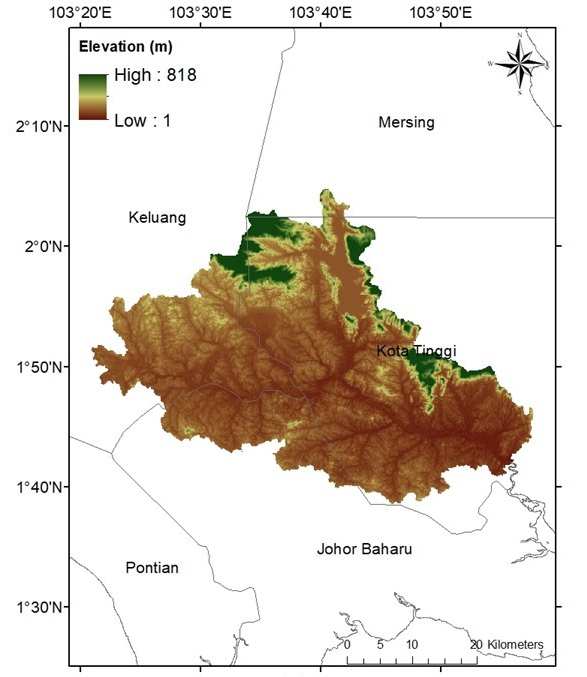
Sungai Johor, or known as Johor River, accounted as the primary river in Johor made up with 122.7km long mainstream that flows southwards from Mount Gemuruh towards Johor Straits (GeoJohor, 2019). With averaging elevation at 109 meters above mean sea level, Johor River Basin (JRB) made up of 2,636km2 catchment area, which composes approximately 14% of Johor state. JRB serves as the main source of water supply to Johor and Singapore. According to the statistics, Syarikat Air Johor (SAJ) and Public Utilities Board of Singapore (PUB) drawing 250,000 cubic meters of water from JRB each day (Department of Irrigation and Drainage, 2012).
One of the significant urban land expansion events in Johor in recent years is the establishment of Iskandar Malaysia special economy region. Established on 8th November 2006, it holds the function as the southern development corridor in Johor. The establishment of this special region covered an area of 4,749km2 where it covers Johor Bahru, Kulai, Pontian, Kota Tinggi, and Kluang districts, with a population of 1.8 million in 2010 (DOSM, 2015). The establishment of Iskandar Malaysia region that occupied 1,654km2 of JRB induced rapid LULC change in the basin, especially at the downstream of Johor River. Johor inherited the equatorial climate that surrounding temperature and humidity are usually high throughout the year and thus it has frequent heavy rainfalls as it located in the tropical region. Figure
Johor River needs to be conserved well as it is functioning as the main water source for the urbanizing plans. Ecological considerations such as sustainability of life for the aquatic life and freshwater resource for human are the key to an amalgamative approach to the management of river and river basin (Sabater & Elosegi, 2014). Geographically, ecological element conditions such as land use change cast the vividness of a river and its basin. As awareness of conserving the water resources increased globally, integrated river basin management becomes one of the popular environmental issues that include consorted use and management of land, water, and other natural resources, as well as activities in a river basin shall be modelled in order to access the sustainability of the river basin (Johnston et al., 2017). By getting to know the future land use change at the river basin, the modelling of the river basin management can be taken into consideration in the future economic region planning to ensure sustainable urbanization for the local community.
Problem Statement
Urban expansion in a city involves transforming the natural landscape into impervious surfaces which are made up of man-made features (Qian & Zhen, 2019). This transformation is an irreversible process due to human benefits from economic trends (Karen et al., 2011). Often, urbanization at an area causing agriculture land loss, urban heat island effect, flood and ecosystem habitat degradation (Chan & Vu, 2017). The work of delineating the spatiotemporal dynamics of urban expansion requires historical LULC data that are available at consistent periods. By studying and analysing the historical LULC change patterns, future land use can be projected. With the future land use change for urbanization estimation done with algorithm statistics, a wiser decision can be made for environment protection and conservation.
There are plenty of studies about urbanization but less discussion on the issues of urban expansion at river basins, as according to World Wildlife Foundation (WWF) river basin is a natural land boundary other than the legal land boundary (Alam et al., 2011). The degradation of river basins would slowly damage the ecology balance of nature. This is because river basins contain fertile soil and water resources that contributed to human well-being in the way of maintaining the water balance of the Earth. With the building of human activities in river basin, the physics of water flow, erosion, deposition of sediments, living of natural flora and fauna will cause the impact of rapid development in river basins. To address this issue, this study will highlight the spatio-temporal LULC changes in the Johor River Basin (JRB).
Research Questions
The research questions for this study are:
What is the rate of LULC change in the JRB?
Which part of the basin had rapid changes?
Purpose of the Study
The purpose of this study is to analyse the LULC changes of JRB in terms of spatially and temporally from 1984 to 2015.
Research Methods
In this study, three land use maps of PLANMalaysia (Jabatan Perancangan Bandar dan Desa) were used to study the historical LULC change. The land use maps of Johor for the years of 1984, 2002 and 2015 were obtained via the Malaysian Centre for Geospatial Data Infrastructure (MaCGDI). The original land use classes of the collected maps were re-classed by grouping with similar land use functions and digital geographic information codes according to MS1759 documentation. This is done by sorting the land use attribute of the collected maps using a Geographic Information System (GIS) for example, ArcGIS, accordingly. Seven LULC class as listed in Table
LULC change detection was done to assess the gaps between each land use class of two consecutive scenes. The extent of change in gain or loss of a land use class was assessed by computing the percentage of change (A) for each class of two consecutive scenes. The expression goes by:
Percentage of change (A) = (F-I)/I x 100%
where A = percentage of change; F = percentage of cells for the class in the later year; I = percentage of cells for the class in the earlier year (Dan-Jumbo et al., 2018).
Findings
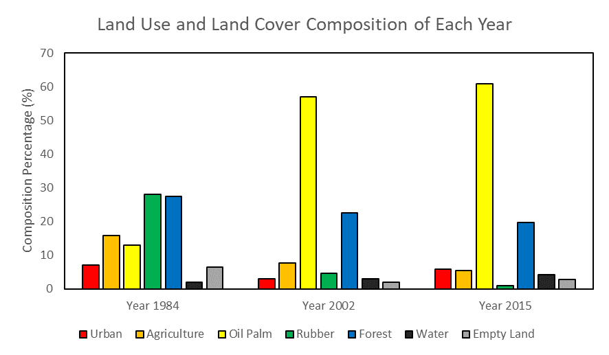
Two major LULC types of JRB in the past few decades were oil palm and forest. The LULC composition for each year processed in this study are as shown in Table
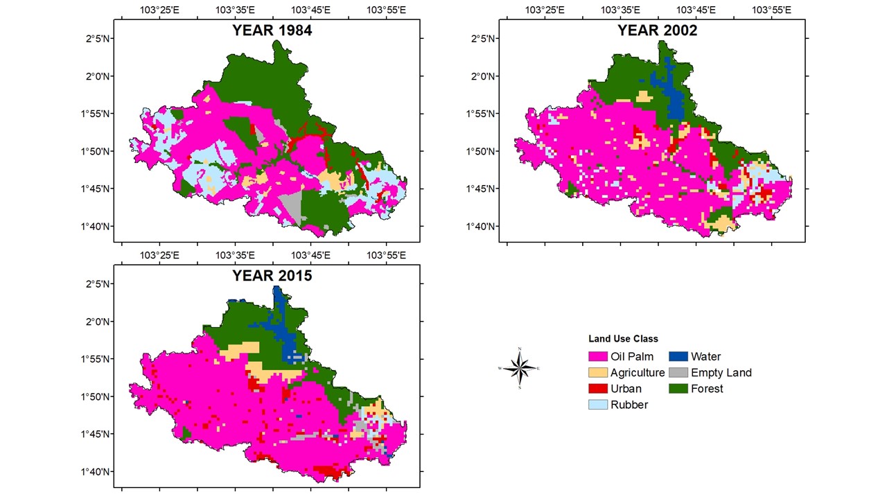
Figures
Conclusion
Understanding the spatial and temporal changes in the historical LULC pattern is critical for impact assessment, town planning, and future LULC simulation. The results show a rapid agricultural expansion and deforestation in the basin for the past 31 years in the JRB. The findings will be used to simulate the future LULC pattern of the basin. Future LULC maps will be then incorporated into hydrological models for simulating future changes of water resources and the hydrological cycle of the basin. Such information is very important for sustainable integrated river basin management system development. However, due to national data privacy policies, the land use data applied in this study could not be shared without permission. Thus, open-source data such as Landsat and Sentinel satellite products could be used as an alternative to providing more open recent land use data for comparison with historical maps.
Acknowledgments
This study was funded by Ministry of Education Malaysia under the Newton-NERC fund entitled “Impacts of Precipitation from Extreme Storms – Malaysia (IMPRESS-MALAYSIA)” (203.PHUMANITI.6780001) and Fundamental Research Grant Scheme (203.PHUMANITI.6711695). The author would like to thank MaCGDI for the kindness of providing the land use data.
References
- Alam, U., Dione, O., & Jeffrey, P. (2011). Hydrology vs Sovereignity: Managing the Hydrological Interdependency of International Rivers. Water Policy, 13(3), 425-442.
- Belal, N. F., Mark, D. P. M., & Rose, O. (2010). Urban sprawl and productivity: Evidence from US metropolitan areas. Papers in Regional Science, 90(3), 23. https://doi.org/10.1111/j.1435-5957.2010.00330.x
- Chan, K. M., & Vu, T. T. (2017). A landscape ecological perspective of the impacts of urbanization on urban green spaces in the Klang Valley. Applied Geography, 85, 89-100. https://doi.org/10.1016/j.apgeog.2017.06.002
- Chen, J. (2003). Modelling Spatial & Temporal Urban Growth [Doctoral dissertation, Utrecht University, The Netherlands]. http://www.itc.nl/library/Papers_2003/phd_theses/cheng_jianquan.pdf
- Dan-Jumbo, N. G., Metzger, M. J., & Clark, A. P. (2018). Urban land-use dynamics in the Niger delta: the case of Greater Port Harcourt watershed. Urban Science, 2(4), 108. https://doi.org/10.3390/urbansci2040108
- Department of Irrigation and Drainage (2012). Hydrological Data. Compiled by Hydrology Division, Malaysia. Retrieved 26 April, 2019, from https://www.water.gov.my/index.php/pages/view/663
- Department of Statistics Malaysia (DOSM) (2015). Population by States and Ethnic Group. Department of Information, Ministry of Communications and Multimedia, Malaysia. Retrieved 26 April, 2019, from https://www.dosm.gov.my/v1/index.php?r=column/ctwoByCat&parent_id= 115& menu_id= L0pheU43NWJwRWVSZklWdzQ4TlhUUT09
- Fallah, B. N., Partridge, M. D., & Olfert, M. R. (2011). Urban sprawl and productivity: Evidence from US metropolitan areas. Papers in Regional Science, 90, 451-472. https://doi.org/10.1111/j.1435-5957.2010.00330.x
- GeoJohor (2019). Johor State Forestry Department. Summary of the State of Johor Forest Management Plan for the period between 2006-2015. pp. 7/71-11/71. Retrieved April 26, 2019 from http://geoportal.johor.gov.my/petaawam/zoninggunatanah/jbahru
- Heidarinejad, N. (2017). The effects of urban expansion on spatial and socioeconomic patterns of the peri-urban areas: a case study of Isfahan city, Iran [Doctoral dissertation, TU Dortmund University, Dortmund, Germany]. https://d-nb.info/1172071969/34
- Johnston, J. M., Barber, M. C., Wolfe, K., Galvin, M., Cyterski, M., & Parmar, R. (2017). An Integrated Ecological Modeling System for Assessing Impacts of Multiple Stressors on Stream and Riverine Ecosystem Services within River Basins. Ecological Modelling, 354, 104-114. https://doi.org/10.1016/j.ecolmodel.2017.03.021
- Karen, C. S., Michail, F., Burak, G., & Micheal, K. R. (2011). A Meto-Analysis of Global Urban Land Expansion. PLoS ONE, 6(8), 9. https://doi.org/10.1371/journal.pone.0023777
- Omid M., Jamal, M., & Asghar, Z. (2012). Urban Form and Sustainable Development: The Case of Urmia City. Geography and Geology, 4(2), 12. https://doi.org/10.5539/jgg.v4n2p1
- Qian, Y., & Zhen, W. (2019). Study on Urban Expansion Using the Spatial and Temporal Dynamic Changes in the Impervious Surface in Nanjing. Sustainability, 11(933), 22. https://doi.org/10.3390/su11030933
- Sabater, S., & Elosegi, A. (2014). Balancing Conservation Needs with Users of River Ecosystems. Acta Biol. Colomb, 19(1), 3-10. https://doi.org/10.15446/abc.v19n1.38045
- Shukla, S., Khire, M. V., & Gedam, S. S. (2013, July). Effects of urbanization on river basin ecosystem-A framework. In 2013 IEEE International Geoscience and Remote Sensing Symposium-IGARSS (pp. 3861-3863). IEEE. https://doi.org/10.1109/IGARSS.2013.6723674
- Tan, M. L., Juneng, L., Tangang, F. T., Chan, N. W., & Ngai, S. T. (2019). Future hydro-meteorological drought of the Johor River Basin, Malaysia, based on CORDEX-SEA projections. Hydrological Sciences Journal 64(8), 921-933. https://doi.org/10.1080/02626667.2019.1612901
- Tjomas, J. N., & Randall, P. W. (2004). Urban Sprawl. Journal of Economic Perspectives, 18(4), 33.
Copyright information

This work is licensed under a Creative Commons Attribution-NonCommercial-NoDerivatives 4.0 International License.
About this article
Publication Date
12 October 2020
Article Doi
eBook ISBN
978-1-80296-088-4
Publisher
European Publisher
Volume
89
Print ISBN (optional)
-
Edition Number
1st Edition
Pages
1-796
Subjects
Business, innovation, sustainability, environment, green business, environmental issues, urban planning, municipal planning, disasters, social impact of disasters
Cite this article as:
Tew, Y. L., & Tan, M. L. (2020). Spatio-Temporal Analysis of Land Use Change in the Johor River Basin, Malaysia. In N. Samat, J. Sulong, M. Pourya Asl, P. Keikhosrokiani, Y. Azam, & S. T. K. Leng (Eds.), Innovation and Transformation in Humanities for a Sustainable Tomorrow, vol 89. European Proceedings of Social and Behavioural Sciences (pp. 210-217). European Publisher. https://doi.org/10.15405/epsbs.2020.10.02.20