
The Anthropic Impact On Relief And Vegetation. Case Study: Valea Ierii

Abstract
The purpose of this research is to analyse the aspects reported by students in four case studies where geographical processes were determined by logging in Valea Ierii Commune, Cluj County. Research involved students who participated in a practical field activity and students who studied the cases only from photographs, answering questions concerned with: identifying causes, conditions and effects; estimating dimensions of environmental components; proposing measures and making predictions. Student responses underwent content analysis and comparison. At the end of the study, we concluded that there were small differences between the resolutions of the students who were in the field and of those who analysed the geographical processes using photographs. All students’ answers indicate that the perception and representation of geographical processes are influenced by competence in the specialty, by the disciplines studied at the Bachelor’s level and by their personal interest in the investigated problems. Regarding the study of cases with photographs, we notice students’ difficulty to estimate dimensions, capacity to identify components, and that many statements are based on their previous knowledge.
Keywords: University studentslearningpractical field activitygeographical processesanalysis of photographs
Introduction
In geographical literature, the anthropic impact represents the positive and / or negative effects of human activity on ecosystems, natural elements and factors, human safety and health or on material goods (Capcelea & Cojocaru, 2005). This impact on the environment, directly or indirectly, causes a change in the state of the ecosystems, which may affect the integrity of the environment, cultural heritage or socio-economic conditions, and in human health (Rojanschi & Bran, 2002). Grădinaru (2004) highlights the existence of three classes of anthropogenic impact (direct, indirect and cumulative) and argues that they can be synergistic or antagonistic. From the recent scientific literature, we considered the following studies regarding this type of geographical endeavour: the study of the anthropic impact on the environmental system of the North-Eastern Metaliferi Mountains (Gligor, 2006), the paper on the quality of the environment in the municipality of Cluj-Napoca (Stoian, 2011), and the one on the environment in the North Moldavian Plateau (Capcelea, 2019).
In this paper, we analyse, from a didactic perspective, several case studies in which the anthropic impact is significant and typical. We will thus investigate students’ learning process during an activity carried out in the field along the Iara River, in Muntele Mare Massif, Valea Ierii Commune (Cluj County), a typical mountain commune, and the observations made in these cases, based on some photographs.
The area in which the investigated cases are located is superimposed on a complex geological substrate, formed in several tectonic cycles (i.e. Prebaikalian, Baikalian, Hercinic, and Alpine), of which the Alpine is the most relevant. Muntele Mare has an overthrust structure, with structural units with their own sedimentary series, located above a crystalline base composed of mesometamorphic, epimetamorphic, and anchimetamorphic series (Ianovici et al., 1976).
On the commune’s territory, the relief has a minimum altitude of 700 m and a maximum of 1,826 m, in Muntele Mare Peak. We identify two steps in the relief, with specific characteristics: the valley corridor step (it represents only 10% of the total area of the commune), located between 700 m and 750 m, and a mountain step, between 750/800 m and 1,826 m. The first step runs along the Iara River, has an elongated shape, low slope (0.1°-5°) and represents an accumulation relief. In the mountainous step, the slopes have a large extension (60% of the commune’s surface) and have predominant surfaces with slopes of 15.1-35° and over 35°. At the level of the watersheds, the Fărcaș-Cârligați levelling erosional surface is identified, with two steps (one above 1,600-1,800 m altitude, the other lower, at 1,400-1,600 m) and the Măguri-Mărișel erosional surface, located between 1,000 and 1,400 m, with two steps, with exceedances in both directions (Pop, 1977 as cited in Bilașco, Cocean, Nicula, & Drăgan, 2013). The relief fragmentation depth is over 500 m.
On the territory of the commune, a cold and humid mountain climate is characteristic. In the neighbouring commune, in Băișoara, at an altitude of 1,370 m, the multiannual average temperature is 4.2 °C, the multiannual thermal amplitude of 18.3 °C and the average precipitation amounts to 977 mm/year (Edroiu, Negucioiu, & Teodor, 1980). Depending on the altitude, in this area, we differentiate the nemoral floor of the deciduous forests (700 and 1,300 m), the boreal floor of the coniferous forests (1,300-1,600 m) and the sub-alpine floor (above 1,600 m altitude; junipers; subalpine pastures). In the landscape, we also notice mix forests (beech with pine; beech with spruce; birch with pine) and secondary pastures and meadow vegetation.
The anthropic impact on the relief and vegetation is determined by a small number of inhabitants. At the 2011 census (INS, 2013), Valea Ierii Commune had 888 inhabitants and a very low population density (6.89 inhabitants/km2). This population domicile in three villages. Valea Ierii locality has its hearth situated on the Iara River meadow and there are few households on the slopes, while the villages Cerc and Plopi have extended households on the erosional surfaces and on the slopes. The human pressure on the environment (constructions, roads, logging) diminished by declaring, in 2007, the Valley of the Iara River (ROSCI0263 Valea Ierii) a protected natural area in the European ecological network Natura 2000 (http://valeaieriinatura2000.ro/).
Problem Statement
Many people carry out actions in the environment in which they live (roads arrangements, mowing, terracing, land cultivating) without being aware of the changes they cause, some of which are irreversible (Dulamă, Ilovan, & Magdaş, 2017; Ilovan et al., 2018b). During the didactic activity, we found that students identify easily the effects of directly perceived geographical processes but have some difficulties in establishing the causes and specifying the conditions that favour or mitigate them (Catalano & Chiș, 2016; Deac, Ilovan, Chiș, & Dulamă, 2019). Poor understanding of the geographical processes is also explained by the fact that, in the Geography Curriculum in pre-university education in Romania (Ministry of National Education, 2017), only small-time resources are given to these issues (Cuc, 2019a, 2019b), and students acquire little knowledge which would be needed to understand the impact of human society on the environment (Chiș, Magdaș, Dulamă, & Moldován, 2019), including the relief and vegetation. At the university level, students are involved in lecture room learning activities (Cuc, 2012) and in practical activities in which they investigate geographical processes (Ilovan, 2019; Ilovan et al., 2018a, 2019b, 2019c; Magdaș, Ilovan, Dulamă, & Ursu, 2018; Rus et al., 2019), but in only a few activities, their level of competence to explain geographical processes will be evaluated in real life contexts (Dulamă, Ursu, Ilovan, & Voicu, 2019; Ilovan et al., 2019a; Koszinski et al., 2019).
Research Questions
Starting from the problems presented above, in this research we look for the answers to the following questions: What are the aspects that students notice in case studies conducted in the field and based on the analysis of some photographs? What difficulties do students have in analysing cases based on photographs?
Purpose of the Study
The purpose of this research is to analyse the perceptions and representations of the anthropic impact on the relief and vegetation by the students who analyse the geographical processes in the field, compared to those who study them in photographs in four case studies identified in Valea Ierii Commune.
Research Methods
Data collecting and processing
Data collection included in two stages. In July 2019, we organised a practical activity along the Iara River, from the exit of this river from the territory of Valea Ierii Commune to the area of Şimo, at the First Aid and Emergency Preparedness Base of the Romanian Red Cross, Cluj branch. On this route, we carried out several research activities in which we observed and analysed the components of the geographical space, various landscapes and some geographical processes. Data collection meant using the observation method, the case study, and photography. In the second stage, we selected the photos and cases proposed for analysis. In each case illustrated by the photographs, we made a list of questions that we asked the participants with the request to phrase concise answers, without additional documentation. The answers underwent content analysis and comparison. The photographs were analysed through visual methods. The guide published by Magdaș (2018) was also considered.
Participants
Three students (one at the Master’s and two Ph.D. level) and one professor with skills in the Sciences of Education participated in the field activity. Thus, the questions were answered by the three students who participated in the field activity and by two students at the Master’s level, who studied only the photographs.
The research material
It consists of field observations and photographs, and students’ answers to questions asked based on photographs.
Findings
In this section, we present the findings of the four case studies.
The 1st case study
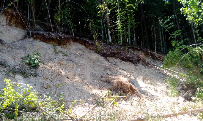
During previous research in the field, on a slope with southern exposure, located in the Iara Valley, upstream of Valea Ierii settlement, we identified a part of a landslide body (Figures
During the current practical field activity, we investigated more thoroughly, by brief observations and discussions with the participants, to establish the conditions that determined the sliding of the rock mass on the slope. It was confirmed the hypothesis that there is a forest road that crosses the body of the slip. The road has an inclination of more than 30°, it is arranged in diluvial deposits with a thickness of over 2 m, made up of chaotic blocks of crystalline systems with dimensions of maximum 30/30 cm, trapped in a clay mass, resulted by disintegration, alteration, and by their displacement from the upper part of the slope and redeposition to its middle and lower part (Figure
After field observations, we asked the students to specify the following: the slope of the versant, the dimensions of the landslide body, the conditions that favoured the production of the landslide, the cause, the evolution, and measures to stop it. Those who analysed the slope in the photograph perceived that it has a lower inclination (30-45°) than in reality (50-60°), an aspect perceived correctly by those who studied it in the field. Estimating the dimensions of the landslide body based on the photographs was difficult, in particular, because objects with known dimensions where not visible. The three students that were in the field estimated the width of 3-15 m, the length of 10-25 m, and one student estimated the surface of the slide body as having 5000 m2. All students considered defrosting as the main cause of this gravitational process. They considered the large slope and the lack of vegetation, visible in the photograph, as conditions that favoured the landslide production and, based on previous knowledge, evoked other potential conditions (the presence of the clay that comes in contact with the water in the substrate; abundant precipitation in a short time and excess ground-water; the existence of a waterproof layer). Regarding future evolution, the students who were in the field noticed the risk of extending the body of the landslide both to the side and to the upper part of the slope, still forested now.
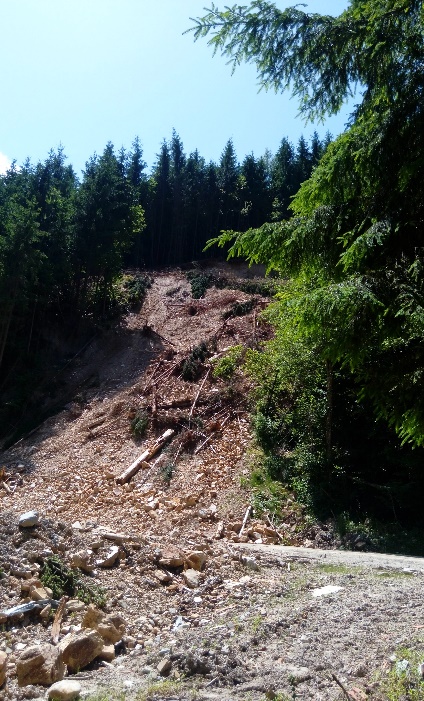
As clues/evidence, a student referred to the bodies of rocks detached from the upper part of the slope, visible in Figure
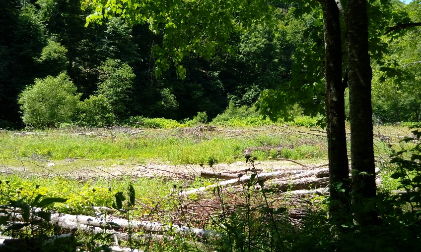
The 2nd case study
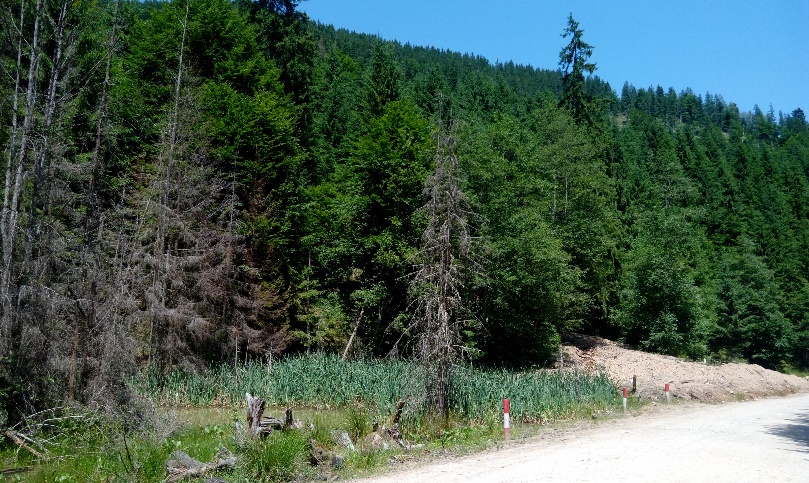
In Figure
The students were asked to remark the conditions that they thought favoured the accumulation of water and the development of the specific vegetation (i.e. rush) visible in Figure
The 3rd case study
On a slope with a southern exposure, with an inclination below 20-30°, we observed an association in which deciduous species with a height of 2-4 m predominate, indicating an age below 15 years (Figure
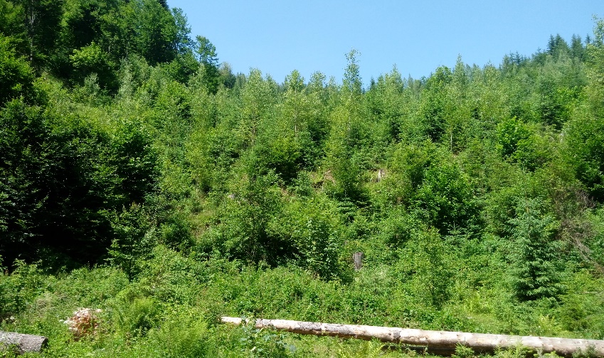
Regarding the vegetation type, the students considered it to be a mixed forest, which includes species of conifers and deciduous trees. Although in the foreground there is a small spruce, the coniferous forest is visible in the photograph towards the upper part of the slope and on the watershed. Because we were interested whether the students noticed the existence of young arbores and that it developed on the site of the former forest, we asked them to mention what differences they observe in the landscape and what are their causes. The students noticed the differences in height and age between the taller and older trees on the left side of the image and those on the right, smaller and younger. The pyramidal shape of the young trees of the deciduous species and probably the smaller spruce, located in the foreground, induced three students to perceive them as conifers and to conclude that there was a vegetation reversal. The fact that the trees in the central part of the image have a lower height was explained by their later planting or by their natural development, subsequent to the development of taller trees. The vegetation inversion and the presence of conifers at the base of the slope was explained through thermal inversion. At the end of the case study, we came to the conclusion that the “clear-cut” felling of the deciduous / coniferous forest resulted in the reduction of the initial forest surface, the destruction of the natural habitat, the natural development of secondary vegetation, and changes in forest composition.
The 4th case study
Downstream of the Commune of Valea Ierii, after a sector with a wide meadow of more than 100 m, a narrow sector begins in which the minor riverbed of the Iara River has direct contact with the slopes. On this broad meadow (Figure
In addition to the results of the four case studies, another finding was that such activities contribute to students’ motivation for learning and overall well-being (see also Cuc, 2019c; Trifan, 2015; Trifan & Chiș, 2017).
Conclusion
At the end of our research, we conclude that in all four case studies within Valea Ierii Commune, the impact was generated by human pressure on the environment through logging. Incomplete and defective human actions (inadequate arrangement of forest roads on the slopes, “clear-cut” felling, cut timber storage, lack of drainage and water runoff facilities) generated a number of negative effects on the environment: the reduction of the forest surface, the destruction of the natural habitats, changes in forest composition, drying of trees, destabilization of the slope base, torrential erosion, landslides, blocking of roads, occurrence of marshes and ponds, installation of new ecosystems, and others. All of these effects cause a negative visual impact in a protected landscape area.
Regarding the aspects perceived and represented by the students about the geographical processes studied in the four cases, we note that there are small differences between the students who were in the field and those who analysed the geographical processes in photographs. These results are explained by the fact that, in the field, the students focused their attention on many geographical aspects (the variety of landscapes, the characteristics of the relief, the space arrangement, the floral variety / biodiversity, etc.) and the four case studies were slightly analysed. The answers given by the students from the two groups indicate that the perception and representation of the geographical processes is influenced highly by their competence in the specialty, by the disciplines studied at the Bachelor’s level, by their personal interest in problems regarding landforms, vegetation, and anthropic activities. Regarding the study of the cases by photographs, we notice students’ difficulty of estimating the dimensions of some elements (landslide head scrap, the body of the slide, the size of the pond, the height of the trees) and of identifying some plant species. Many statements about geographical processes are more based on previous knowledge than on careful observation of photographs.
Acknowledgments
All authors contributed equally to this research paper.
References
- Bilaşco, Ș., Cocean, P., Nicula, G., & Drăgan, M. (2013). Conditionarea morfometrica a pretabilitatii de amenajare teritoriala in bazinul vaii Ariesului [Morphometric conditioning of territorial planning possibility in the Arieş river basin]. Geographia Napocensis, 7(1), 21-35.
- Capcelea, A., & Cojocaru, M. (2005). Evaluarea de mediu [Environmental assessment]. Chișinău: Știința.
- Capcelea, V. (2019). Impactul antropic asupra mediului din Podișul Moldovei de Nord (începând cu anul 1990) [The anthropic impact on the environment in the Northern Moldavian Plateau (since 1990)], (Doctoral Dissertation). Chișinău: Tiraspol State University, Faculty of Geography.
- Catalano, C., & Chiș, O. (2016). Comparative study between students’ teaching practice activities in Hungary and Romania. European Proceedings of Social and Behavioural Sciences, 18, 74-78.
- Chiș, O., Magdaș, I., Dulamă, M. E., & Moldován, K. R. (2019). Learning through cooperation and project method in pre-school education in Romania. European Proceedings of Social and Behavioural Sciences, LXIII, 565-572.
- Cuc, M. C. (2012). Educational strategies for training teachers to promote excellence. 8th International Scientific Conference eLearning and Software for Education, Leveraging Technology for Learning, I, 141-145.
- Cuc, M. C. (2019a). Particularities of regulatory mechanisms in gymnasium students. European Proceedings of Social and Behavioural Sciences, LXIII, 44-54. https://doi.org/10.15405/epsbs.2019.06.7
- Cuc, M. C. (2019b). The relationship between self-esteem and academic success. European Proceedings of Social and Behavioural Sciences, LXIII, 36-43.
- Cuc, M. C. (2019c). The Well-Being – A Fundamental Indicator in Didactic Activity. European Proceedings of Social and Behavioural Sciences, LXIII, 55-65.
- Deac, A. S., Ilovan, O.-R., Chiș, O., & Dulamă, M. E. (2019). Primary grades teachers’ perceptions of learning activities in nature. European Proceedings of Social and Behavioural Sciences, LXIII, 358-364.
- Dulamă, M. E., Ilovan, O.-R., & Magdaş, I. (2017). The forests of Romania in scientific literature and in geography. Teachers’ perceptions and actions. Environmental Engineering and Management Journal, 16(1), 169-186.
- Dulamă, M. E., Ursu, C.-D., Ilovan, O.-R., & Voicu, C.-G. (2019). Increasing generation Z geography students’ learning through didactic films in university. Proceedings of the 14th International Conference on Virtual Learning, 79-85.
- Edroiu, N., Negucioiu, A., & Teodor, P. (1980). Cluj: Monografie [Cluj: monograph]. Bucharest: Sport-Turism Publishing House.
- Gligor, V. (2006). Impactul antropic asupra sistemului environmental al Munţilor Metaliferi de nord-est [Anthropic impact on the environmental system in the north-est of the Metaliferi Mountains]. Pangeea, 6, 82-86.
- Grădinaru, G. (2004). Bazele statisticii mediului [Basics of environmental statistics]. Bucharest: ASE Publishing House.
- Ianovici, V., Borcoş, M., Bleahu, M., Patrulius, D., Lupu, M., Dimitrescu, R., & Savu, H., (1976). Geologia Munților Apuseni [Geology of the Apuseni Mountains]. Bucharest: Romanian Academy Publishing House.
- Ilovan, O.-R. (2019). Studying the urban landscape at university: web-based research and visual imagery. Proceedings of the 14th International Conference on Virtual Learning, 70-78.
- Ilovan, O.-R., Dulamă, M. E., Andron, D., Bălan, P.-M., Muntean, D.-O., Toderaș, A., & Ciocan, M. (2019a). Developing students’ competence to analyse landscapes during geography university studies. European Proceedings of Social and Behavioural Sciences, LXIII, 398-408. https://doi.org/10.15405/epsbs.2019.06.49
- Ilovan, O.-R., Dulamă, M. E., Boțan, C. N., Ciascai, L., Fonogea, S.-F., & Rus, G. M. (2018a). Meaningful learning: case studies on the territorial identity of historical urban centres. European Proceedings of Social and Behavioural Sciences, 41, 413-421. https://doi.org/10.15405/epsbs.2018.06.49
- Ilovan, O.-R., Dulamă, M. E., Boţan, C. N., Havadi-Nagy, K. X., Horvath, C., Niţoaia, A., ... & Rus, G.M. (2018b). Environmental education and education for sustainable development in Romania. Teachers’ perceptions and recommendations. Journal of Environmental Protection and Ecology, 19(1), 350-356.
- Ilovan, O.-R., Havadi-Nagy, K. X., Dulamă, M. E., Mutică, P., Adorean, E.-C., Colcer, A.-M., & Cimpoieș, P.O. (2019b). Learning challenges and benefits during the International Workshop on Urban Regeneration. European Proceedings of Social and Behavioural Sciences, LXIII, 330-338. https://doi.org/10.15405/epsbs.2019.06.41
- Ilovan, O.-R., Maroși, Z., Adorean, E.-C., Ursu, C.-D., Kobulniczky, B., Dulamă, M. E., & Colcer, A.-M., (2019c). E-Learning urban landscape changes in post-socialist Romania using digital mapping. Proceedings of the 14th International Conference on Virtual Learning, 62-69.
- INS (2013). Definitive results of the Population and Housing Census - 2011 (demographic characteristics of the population). Retrieved from http://www.recensamantromania.ro/wp-content/uploads/2013/07/REZULTATE-DEFINITIVE-RPL_2011.pdf
- Koszinski, S. A., Dulamă, M. E., Ilovan, O.-R., Scridon, I., Toderaș, A., & Popa, A.R. (2019). Regional Geography and graphic organisers geography-specific and didactic competences in university. European Proceedings of Social and Behavioural Sciences, LXIII, 389-397. https://doi.org/10.15405/epsbs.2019.06.48
- Magdaș, I. (2018). Prezentarea și prelucrarea datelor cercetării în științele educației. Ghid pentru studenți [Presenting and processing research data in the Sciences of Education. A students’ guide]. Cluj-Napoca: Presa Universitară Clujeană.
- Magdaș, I. C., Ilovan, O.-R., Dulamă, M. E., & Ursu, C. D. (2018). Visual materials from web sources in studying regional geography topics. Proceedings of the 13th International Conference on Virtual Learning, 278-284.
- Ministry of National Education (2017). School syllabus for Geography. The 5th - 8th grades. Annex no. 2 to the Order of the National Education Ministry no. 3393 / 28.02.2017. Bucharest: National Education Ministry.
- Rojanschi, V., & Bran, F. (2002). Politici şi strategii de mediu [Environmental policies and strategies]. Bucharest: Economic Publishing House.
- Rus, G.-M., Dulamă, M. E., Ursu, C.-D., Colcer, A.-M., Ilovan, O.-R., Jucu, I. S., & Horvath, C. (2019). Online apps, web sources and electronic devices: learning through discovery about Valea Ierii [Iara Valley]. Proceedings of the 14th International Conference on Virtual Learning, 110-119.
- Stoian, L. (2011). The anthropic impact on the quality of the environment in the city of Cluj-Napoca (Doctoral Dissertation). Cluj-Napoca: Faculty of Geography, Babeș-Bolyai University.
- Trifan, I. M., & Chiș, O. (2017). Social and emotional development in the early years. In I. Albulescu, A.-D. Manea & I.-M. Morariu (Eds.), Education, Religion, Family in the Contemporary Society. Proceedings of the Conference (pp. 133-140). Saarbrücken: Lambert Academic Publishing.
- Trifan, I. M. (2015). Promoting the Emotional Wellbeing of Preschoolers. Procedia - Social and Behavioral Sciences, 209, 509-513.
Copyright information

This work is licensed under a Creative Commons Attribution-NonCommercial-NoDerivatives 4.0 International License.
About this article
Publication Date
17 June 2020
Article Doi
eBook ISBN
978-1-80296-084-6
Publisher
European Publisher
Volume
85
Print ISBN (optional)
-
Edition Number
1st Edition
Pages
1-814
Subjects
Teacher, teacher training, teaching skills, teaching techniques, special education, children with special needs
Cite this article as:
Rus, G., Ilovan, O., Dulamă, M. E., Chiș, O., Ursu, C., Colcer, A., & Horvath, C. (2020). The Anthropic Impact On Relief And Vegetation. Case Study: Valea Ierii. In V. Chis (Ed.), Education, Reflection, Development – ERD 2019, vol 85. European Proceedings of Social and Behavioural Sciences (pp. 768-778). European Publisher. https://doi.org/10.15405/epsbs.2020.06.80