
Land-Use Planning: Historical Aspects


Abstract
Urban development is the research and practical activities of planning, development and management of settlements. These settlements may include cities, towns, rural settlements, and the systems of settlements. The urban development aims to form the material and territorial environment. Such development is used to locate territorial and functional facilities, which change their parameters over time. The term “land-use planning” is referred to decision-making concerning the settlement development. Territorial entities that include countries, regions, and their integral parts are land-use planning objects. The article deals with the issues of historical development of the land-use planning system and changes in urban development policies of the Russian Federation. The issue of ideal towns of the Renaissance Era, which were most comfortable and safe places, is touched upon. The methodical development plan of Saint Petersburg is described. Besides, the article describes a scheme of land-use planning of Irkutsk oblast. Research results can improve the urban planning system of land-use.
Keywords: Urban developmentland-use planningland-use planning schemesthe first Committee on buildings
Introduction
Urban development is research and practical activities of planning, development and management of settlements (cities, towns, rural settlements, systems of settlements). It aims to form the material and territorial environment. Urban development is used to locate territorial and functional facilities which change their parameters over time. The most significant tasks are settling of people within the country or its regions.
Problem Statement
The term “land-use planning” refers to settlement development decision-making. The territory (region, district) planning is research, project and management activities aimed to ensure rational location and combination of people, production facilities, and natural objects. The land-use planning determines the strategy of territorial, social and economic and environmental development of large territorial entities (countries and their regions).
Land-use planning objects are territorial entities – countries, regions and their integral parts.
As complex joint activities of government authorities and experts, the land-use planning has existed for about one century. However, spatial decisions have been made since for a long time.
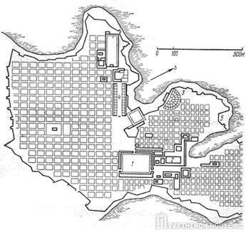
In the Antique Era, Ancient Greek architect and builder Hippodamia, a founder of the urban development planning, developed regular rectangular plans for Miletus and Piraeus (the 5thcentury BC.) (see Figure
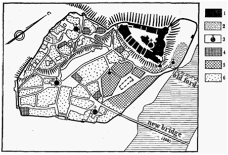
High density of buildings, low population density and small sizes due to the need for a reduction of the perimeter of defense town walls were typical of medieval towns. Many medieval towns were located near castles or monasteries in mounts where residents sheltered. Medieval towns had typical pyramidal structures (see Figure
In the Renaissance Era, architects searched for unique utopian architectural and philosophical urban development decisions. They developed ideas of an ideal town which would be comfortable and safe (Studfiles, 2018; Yas'kova, 2018).
Research Questions
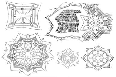
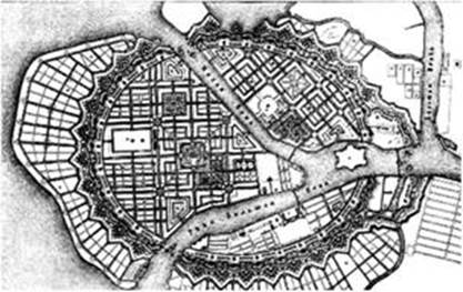
An ideal town has a star geometry, an inscribed polygon with an accurate planning system (see Figure
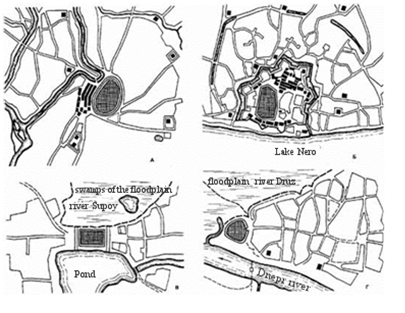
Russian towns of the 10-15th centuries consisted of three elements: a fortress, a ring, and a trading quarter. This three-element structure was typical of small towns and early cities.
Purpose of the Study
The shape of a fortress is an important criterion of the structural typology of cities (see Figure
In 1709, the first Committee on buildings was founded in Saint Petersburg. It became a public designing and construction control agency. The orders of Peter the Great on red lines, fire-prevention measures, stone building development, wide application of green plants served as construction rules for development of new types of cities (Maloyan, 2004). A construction police which enforced construction rules was created. As a result of the 34-year activities of the Committee (1762–1796), new urban development plans for 416 out of 497 towns were developed.
Research Methods
In the era of Peter the Great, methodical measures aimed to develop a Saint Petersburg development plan were a crucial stage of the Russian urban development. They were implemented by Jean Baptiste Leblonc (see Figure
The Irkutsk oblast land-use planning scheme was approved by regional order No 607-pp of November 2, 2012, regional order No 355-pp of July 23, 2015 “On amendments to the Irkutsk oblast land-use scheme”. The scheme was published in the Federal Information Irkutsk oblast land-use planning system, on the Irkutsk oblast Government and Irkutsk Architecture Service websites (Government of Irkutsk region, 2018; FGBUB Russian State Research and Design Institute of Ubianistics, 2018)
The scheme was developed in compliance with Articles9, 15 and 16 of the Urban Planning Code of the Russian Federation following the land-use planning rules of Russia, Russian regions, municipal entities, and regional urban development standards.
Findings
The Irkutsk oblast land-use planning scheme includes:
A territory use scheme (a support plan);
A scheme of municipal boundaries;
A project scheme;
A location scheme for regional capital construction objects;
A scheme of special zones;
A location scheme for transport and communication facilities;
A location scheme for energy facilities;
A location scheme for regional social facilities.
The maps of the land-use planning scheme show:
Municipal boundaries – boundaries of urban and rural areas approved by regional governments of the Russian Federation;
Boundaries of forest lands, regional significance protected areas, defense and security lands;
Boundaries of agricultural and farm lands, planned boundaries of these lands;
Boundaries of cultural heritage sites;
Boundaries of use-restricted areas;
Boundaries of areas exposed to natural and technogenic risks and their effects;
Boundaries of lands where regional significance capital construction objects are located or are planned to be located;
Conclusion
Research results can improve the territorial urban planning system. Functional zones (segments of the urban territory contoured with closed curves) are created in the urban territory: residential (residential buildings, public buildings); industrial (manufacturing enterprises, research institutions); recreational – urban forests, parks, water reservoirs, agricultural lands (Bolshakov, 2014).
The Urban Development Code of the Russian Federation divides urban areas into residential areas, public and business areas, industrial areas, areas of communication and transport facilities, agricultural lands, recreational and protected areas, special purpose areas, areas of military facilities and other territorial areas.
References
- Bolshakov A.G. (2014). Fundamentals of urban development and district planning: Course book 630100 Architecture; the Ministry of Education and Science of the Russian Federation, Irkutsk Technical University. Irkutsk: ISTU.
- Еmsu.ru, (2018). Urban planning. Retrieved from http://emsu.ru/um/archit/art/plan.htm
- FGBUB Russian State Research and Design Institute of Ubianistics, (2018). Irkutsk oblast territory planning scheme. Retrieved from http://mognovse.ru/jrq-shema-territorialenogo-planirovaniya-irkutskoj-oblasti.html
- Government of Irkutsk region, (2018). Irkutsk oblast territory planning scheme: Retrieved from http://irkobl.ru/sites/saio/terplan/stp-io/
- Historical Library (2018). Historical geography of the Western Europe in the Middle ages. Retrieved from http://historylib.org/historybooks/V--V--Samarkin_Istoricheskaya-geografiya-Zapadnoy-Evropy-v-srednie-veka/11.
- Historical Library (2018) Territory planning scheme. Retrieved from http://www.irkraion.ru/skhema-territorialnogo-planirovaniya.
- Maloyan, G.A., (2004). Urban development fundamentals. Moscow: Construction Universities Association.
- Studfiles (2018). The use of topographic area conditions when developing ancient Russian cities. Retrieved from https://studfiles.net/preview/3736015/page:16/ .
- Yas'kova, N.Yu., (2018). Construction in the context of new views on the goals of economic development. Proceedings of high schools. Investments. Construction. The property. No. 1 (24, 133-142.
Copyright information

This work is licensed under a Creative Commons Attribution-NonCommercial-NoDerivatives 4.0 International License.
About this article
Publication Date
17 December 2018
Article Doi
eBook ISBN
978-1-80296-049-5
Publisher
Future Academy
Volume
50
Print ISBN (optional)
-
Edition Number
1st Edition
Pages
1-1464
Subjects
Social sciences, modern society,innovation, social science and technology, organizational behaviour, organizational theory
Cite this article as:
Matveeva, M., Kaluzhnova, N., & Peshkov, A. (2018). Land-Use Planning: Historical Aspects. In I. B. Ardashkin, B. Vladimir Iosifovich, & N. V. Martyushev (Eds.), Research Paradigms Transformation in Social Sciences, vol 50. European Proceedings of Social and Behavioural Sciences (pp. 763-768). Future Academy. https://doi.org/10.15405/epsbs.2018.12.94