
Analysis Of Alternative Trade Route Based On Earliest Cartography And Textual Data


Abstract
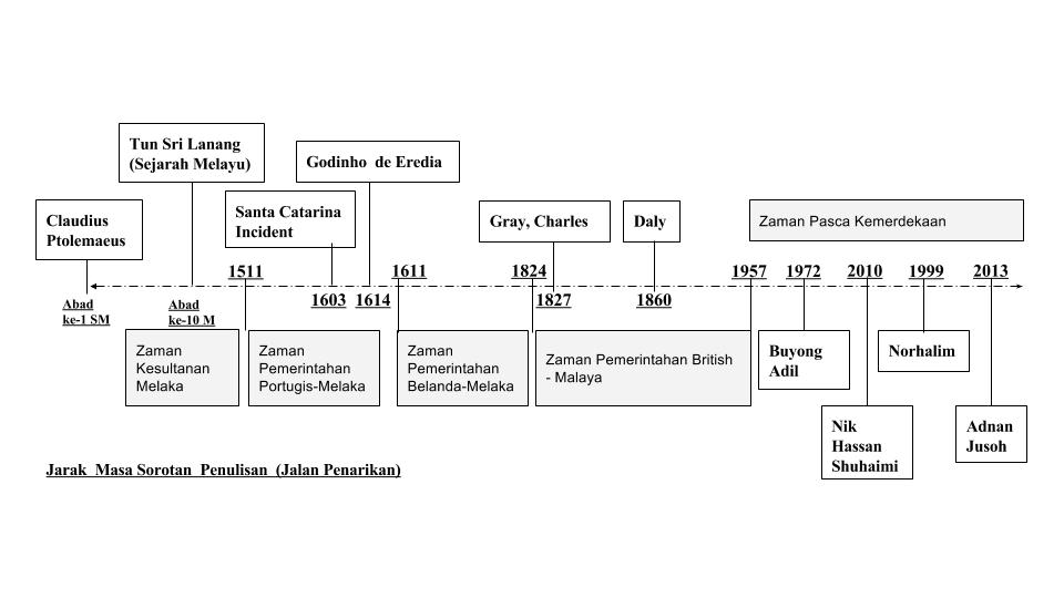
The Malay Peninsular as known to the west during ancient times is a center of commerce that trade goods of luxury and necessity. First known map (reconstituted in 1407) of it is drawn by Ptolemy (c.100-178) while serving for Alexander the Great in his quest to conquer Asia. Ptolemy’s map shows the position of Muar and Pahang river that can be crossed from east to west coast of what he called ‘Aurea Chersonesus’ or Golden Peninsula. However, Ptolemy’s map shows errors, in specific that Muar and Pahang river is connected, and the peninsula can be crossed through these two rivers. As in fact, the river route goes through Pahang river (east-coast) tributaries and can only be crossed through ‘Jalan Penarikan’ into Muar river (west-coast). ‘Jalan Penarikan’ is an overland route of 600 meter which goods and vessels (perahus and junks) has to be pulled by human, elephants and buffalos. Buyong Adil suggests that this route was only used by locals and officials of surrounding states in their trade, administration and military support. Eredia wrote in 1614 that one can reach Pekan from Muar in 6 days through ‘Jalan Penarikan’ in contrast with the known sea route which take 6 months.
Keywords: Panarican PortageAncient Trade RouteMalay Peninsula
Introduction
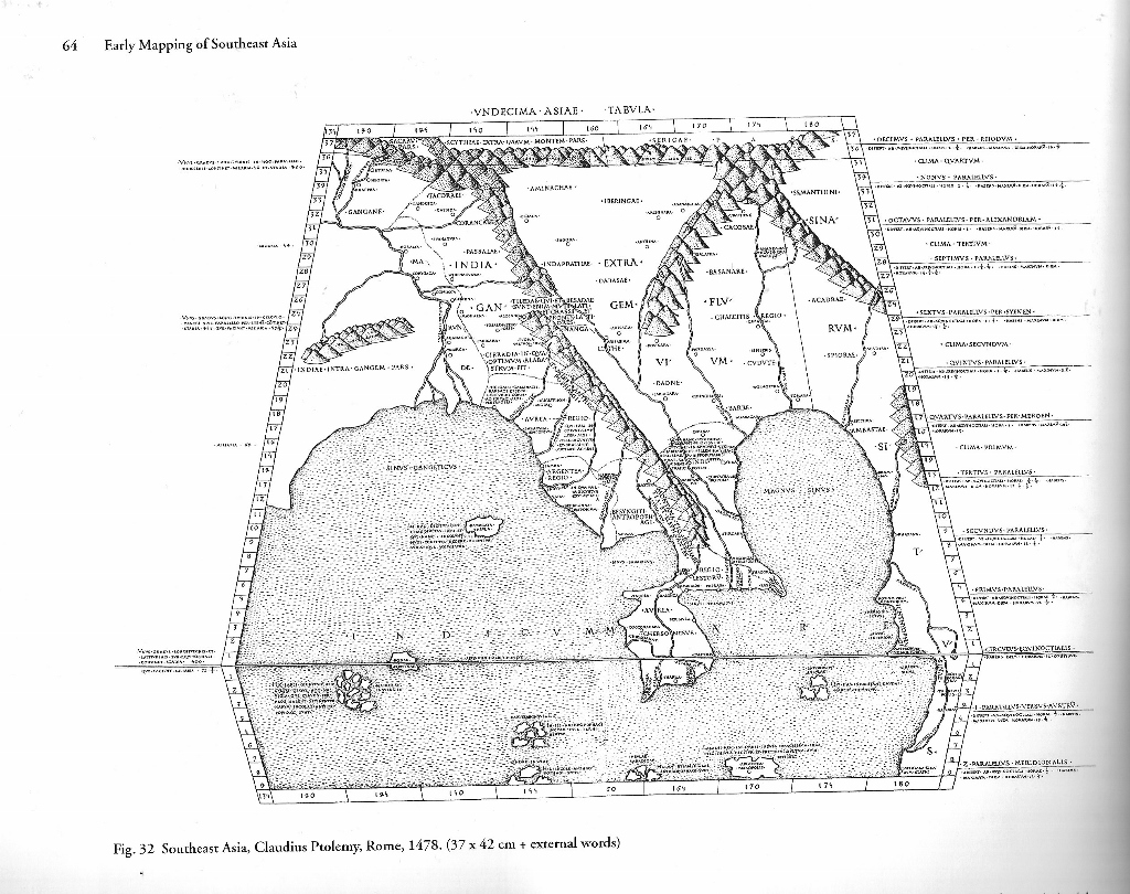
According to Wheatley, the earliest surviving cartography of South-East Asia found in the ‘Geography’ (figure
The produce of gold was always the factor that attracts foreign traders to the Malay Peninsula apart from other necessity goods. When Junks were driven by the force of wind and oars, traders from the east which carries mostly silk and spices, would have to sail with the southern wind which is only strong for three months in a year down to the straits of Johor to reach Malacca. The same force of nature would drive traders from the west that came to Malacca to trade. Braddell suggest that Peninsula Malaysia and its isthmus acts as a barrier that divides east and west3 thus creating this trade route, but he also marked the risk of sailing the open sea such as pirates and rough seas. This note contributes to the need of crossing the peninsular through rivers and its tributaries that would save time in trading. Borschberg note in reference to Wheatley stressing that the ‘Pahang-Muar Riverine Network’ was and important route used by Asian traders thus using ‘Jalan Penarikan’ and is still in operation until the early 16th century. Wheatley also wrote a topic of ‘Trans-peninsular Route’ stating factors contributing to the need of ‘Jalan Penarikan’.
Of all the above, this paper is hoped to revive and document the existence of ‘Jalan Penarikan’ first, to understand why it has so little mapping evidence and were only found drawn by foreign cartographers and not the locals, second, why do local authors often write the time of use without giving data on how it runs, third, to analysed when and what is the caused that such transportation hub no longer needed.
Problem Statement
Issue in focus is in finding credible early cartograph. A few can be found drawn by European cartographers, but no mapping evidence could be found drawn by local cartographer. Local authors write on the event of use of ‘Jalan Penarikan’ but then again, no clue can be found explaining the process of ‘Jalan Penarikan’
Research Questions
This thesis was generated based on a few questions pertaining the finding of the origin of ‘Jalan Penarikan’ as listed below.
Earliest Mapping
The search for this factor depends solely on when the two rivers of Sungai Muar and Sungai Pahang were first drawn and then develop to the correct location. Sources from Wheatley and Suarez were identified and analysed.
Textual Data on Jalan Penarikan
Literature reviews of South East Asia trade route, Sungai Muar and Sungai Pahang river route and the governance of ancient Johore, Malacca and Pahang were used to find out questions below.
When ‘Jalan Penarikan’ was establish and when was the last time it’s been used.
Who is the administrator of ‘Jalan Penarikan’ and why it is used?
Purpose of the Study
This study is to identify the existence of ‘Jalan Penarikan’ as one of ancient trade route in South East Asia. The writing about ‘Jalan Penarikan’ were found in most historical books and journals but were explained in brief with no link to its origin and governance. Its historical background shows a significant mark in transportation of human and commerce and to be analysed in routes of trade in South East Asia perspective.
Research Methods
Methodology of research were based on literature reviews by European and local authors, and early mapping of South East Asia.
Literature Review
Textual data taken from local authors were arranged by its relevancy to the usage of ‘Jalan Penarikan’. Journal made by foreign explorers are also analysed to find possible clue of its administrative and infrastructure scene. On the other hand, local authors provide little statement on the course of ‘Jalan Penarikan’ but instead are using moments of war, migration and inter-government affairs in military support. These events and places were only recorded in text explaining name of town, river route used and places of destination.
This study mainly focuses on getting the closes textual fact to find out the actual scenario of Jalan Penarikan during its heyday. No doubt from the literature review on chapter 2, it is repeated in citing by authors in their book a small section explaining Jalan Penarikan. The question of where it is, has shown many clues but who is the authority concern, how exactly the boats, ships and its cargo where carried across Jalan Penarikan and security matters of going through it remains in the scarcity of the textual data.
Authors from the west such as Mills, Braddell, Wheatley, Muzz and Borchberg when writing about the history of the Malay Peninsula, has not left the sub topic of Trans Peninsula Route and ‘Jalan Penarikan’. Each of them has their own analysis approach and interpretation in their story of the history of Malay Peninsula. Literature reviews of ‘Jalan Penarikan’ are cited in sequence of when it was found, by whom and most important is why these western cartographers are interested in the Malay Peninsula.
The textual review analysis starts with Geraldo Affonso Muzzi who writes about Ptolemaic mapping of South-East Asia.
Citation from local authors can be find as selected below
“Jalan inilah yang telah diikut oleh Sultan Mahmud Shah Melaka dan putera baginda Sultan Ahmad satelah mereka dikalahkan oleh orang-orang Portugis di Pagoh dan Bentayan (Kuala Muar) pada akhir tahun 1511. Dan jalan inilah juga yang diikuti oleh Sultan Ali (putera Sultan Husain Shah Singapura) dari Kampung Umbai, Melaka, pergi berjumpa bendahara Wan Ahmad di Pahang (Pekan) pada tahun 1863” (Adil,1971). Buyong Adil added that when Sultan Mahmud Shah of Malacca was defeated by the Portuguese in Pagoh and Bentayan(Muar), Sultan Ali when to see Wan Ahmad in Pahang using Muar-Pahang riverine route thus going through ‘Jalan Penarikan’ to inform Sultan of Pahang.
“Pada tahun 1511 (bulan Ogos), Sultan Mahmud Shah telah dikalahkan oleh orang Portugis dibawah ketuaan Alfonso de Albuquerque; Melaka pun jatuh ke tangan Portugis; Sultan Mahmud Shah serta anak isteri dan pengikut-pengikut baginda berlepas diri ke Hulu Muar, lalu berkerajaan di Pagoh (dalam daerah Muar). Pada akhir tahun 1511 itu juga, Pagoh telah dialahkan oleh orang Portugis. Sultan Mahmud Shah serta pengikut-pengikut baginda berlepas diri ke hulu lagi sampai ke tempat yang bernama Penarekan baginda menghilir Sungai Pahang lalu sampai ka negeri Pahang” (Adil,1972). Pahang Perentah Raja-raja Melaka, p. 41). The author wrote, in August 1511, Sultan of Malacca was defeated by the Portuguese under the command of Alfonso de Albuquerque, withdraw with the royal family and his highness men to upper Muar river at a place called Pagoh. Here he setup a new command post to withstand attack from the Portuguese. At the end of 1511, Portuguese came and defeated Pagoh. The royal convoy now move to Pahang via going up River Muar until Jalan Penarikan across to Sungai Serting (tributary of Sungai Pahang).
“Pada awal bulan Januari 1827, ada seorang Inggeris bernama Gray telah melawat ke negeri Pahang kerana hendak menjual chandu dan membeli emas urai yang banyak didapati di negeri Pahang. Dia telah bertolak dari Melaka pergi ke Pahang ikut jalan sungai melalui Jempol, Sungai Serting, Sungai Bera, menghilir Sungai Pahang lalu sampai ke Pahang (Pekan ibu negeri Pahang). Dalam buku penghariannya yang kemudiannya di chap oleh T.J. Newbold antara lain-lain Gray telah mencatatkan dalam bukunya itu; ‘Pada 9 haribulan January 1827, saya dan sembilan orang-orang yang saya bawa, lengkap dengan senjata, telah bertolak mengunakan perahu meninggalkan Jempul menuju ke Pahang. Satelah hilir ke Sungai Jempol hampir sejam lamanya, kami pun berjalan membawa perahu kami ikut jalan darat sejauh tiga ratus ela (di Penarekan) lalu masuk ke Sungai Serting. Malamnya kami berhenti di sebuah kampung kechil bernama Bahru (?Bahau) dekat tebing Sungai Serting. Lepas itu kami berperahu lalu sampai ke Tasek Bera pada 13 haribulan Januari 1827 pukul 2 malam…...Lima hari lamanya kami belayar dari Tasek Bera Baharu masuk ke Sungai Bera. Tempat-tempat di antara Bahru(?Bahau) hinggalah ke Sungai Bera tidak ada didiami orang melainkan orang-orang yang disebut oleh anak negeri ‘orang Hutan’ (orang asli) yang selalu datang ke Sungai Serting menangkap ikan. Gajah terlalu banyak……….” (Tsukasa, 1852) On another chapter, Buyong Adil cited journal by Charles Gray (edited by T.J Newbold), on the early January 1827, Gray accompanied by 9 of his armed escort, went to Pahang from Malacca by using Sungai Muar up stream to Sungai Jempol across Jalan Penarikan to Sungai Serting and downstream via Sungai Bera and Sungai Pahang reaching Pekan (capital of Pahang in before the arrival of British). We spend an hour on perahu (boat) at Sungai Jempol to reach the start point of Jalan Penarikan. Here they pulled their boat on land across to Sungai Serting (600 meter) to continue journey to Pahang. That night we stopped at small village called Bahru (probably Bahau) at the bank of Sungai Serting. It took us 5 days from Lake Bera to Sungai Bera. The places from Bahau to Sungai Bera has no settlement except for the aboriginal that often fish at Sungai Serting. There’s a lot of elephants.
“Menurut sumber tempatan, laluan penarikan ini sangat berkait rapat dengan sejarah kesultanan Melaka, Negeri Sembilan dan juga Pahang. Laluan berkenaan juga dikaitkan dengan perkembangan Islam di kawasan pendalaman oleh saudagar perniagaan dari Pasai dan Arab sekitar abad ke 11.” (Asyaari Muhammad, 2007) According to local sources, Jalan Penarikan relates very closely to the Sultanate of Malacca, Pahang and Negeri Sembilan. Same route also being associated with the evolution of Islam in the interior of the Malay Peninsula by the merchants from Pasai (Aceh) and Arab during the 11th century.
“Memandangkan bahawa aktiviti perdagangan antara bahagian dalaman negeri-negeri Melayu dengan negeri-negeri kota yang terletak dibahagian pesisir Semenanjung Tanah Melayu telah lama berjalan, besar kemungkinan Jalan Penarikan ini telah digunakan lebih awal daripada itu; iaitu pada zaman keagungan kerajaan-kerajaan Langkasuka, Serivijaya, Palembang, Majapahit (abad ke 14). Semenjak abad-abad tersebut, jalan ini terus digunakan, samada dalam keadaan aman atau sebaliknya, sehingga awal abad ke-20. Kepopularan Jalan Penarikan ini mulai merosot apabila kerajaan Inggeris membina landasan keretapi yang menghubungkan Bahau dengan Kuala Pilah dan kemudian dengan kawasan pantai timur semenanjung Tanah Melayu. Landasan keretapi tersebut the siap dalam tahun 1931.” (Asyaari Muhammad, 2007) The fact that trading in between the interior of the Malay States and the cities along the shores of Malay Peninsula has been active for a long time, most likely that Jalan Penarikan were in use prior to this. That is from the period of Langkasuka, Srivijaya, Palembang and Majapahit Empire during the 14th century. From this point, Jalan Penarikan has always been used in either peace or war time until the early of 20th century. The usage of Jalan Penarikan decreases dramatically when the British built a railway (completed in 1931) connecting Bahau with Kuala Pilah and later to the east coast.
“Informants working for the Portuguese were stationed in Tioman (a much-frequented provisioning station and watering hole for all sort of ship of all nationalities) to warn Lusitanian captains and pilots of Dutch freebooters. Dutch sources explain how Portuguese-flagged vessels were re-routed to the port of Pahang and unloaded there, and goods were transported along the rivers and the panarican across the Peninsula to Muar.” (Borschberg, 2010) On his note, mentioned, when the Portuguese where blocked while sailing to Malacca from China, they re-routed their vessels to Pekan, Pahang, unloaded to smaller perahu and went upstream Pahang river and through Jalan Penarikan reaching Muar. This has been the route for the Portuguese getting food supply for their army in Malacca when the route through Johore Straits was blocked by the Dutch vessels.
“Dutch policies of plundering and despoiling their Lusitanian enemy in the region of the straits, especially after the Santa Catarina incident in 1603, evidently let to an upgrading of the Pahang-Muar riverine network (Borschberg, 2010) He added after the incident of Portuguese vessel named Santa Catarina was captured by the Dutch army in 1603, the usage of Pahang-Muar trans-peninsula route (Jalan Penarikan) started being used by the Portuguese frequently.
“Whatever the case might have been, there was probably more than one such important riverine network used by Asian traders. Paul Wheatley recognize the significance of the Pahang-Muar riverine network for the 16th century, primarily in the production or panning of gold dust in parts of the Malay Peninsula but surviving documentary evidence suggest that the commercial significance at the close of 16th and the opening of the 17th centuries extended beyond the supply of gold.” (Borschberg, 2010) In citing Wheatley’s, Borchberg noted that Jalan Penarikan might have been active until the early 17th century and other product was also traded such as spice, aromatic bark and silk.
Analysis of Early Maps
Most of early maps of the Malay Peninsula was drawn by western cartographers but only transcripts and texts recording can be found stating the usage of ‘Jalan Penarikan’. These two types of data were analysed in a timeline to identify its existing, usage, peak and ends (Figure
Data on maps are rearranged from the first known by Claudius Ptolemaeus in the 1st century and reconstituted in1478 referred to Suarez. In this map, one can identify the large indentation of river Khrysoanas, Palandas and Attabas, but the three rivers in closer look, are dividing end of Malay Peninsula into three smaller islands (figure
The next evolution of Peninsula Malaysia map, shows a deep indentation of River Muar and River Johor thus dividing the southern part of the peninsula into an island.
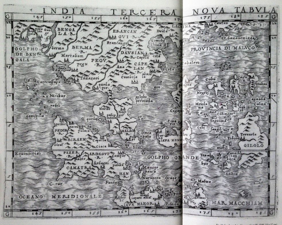
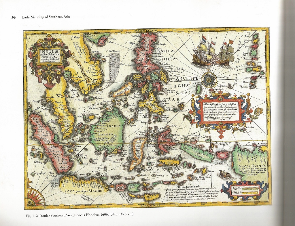
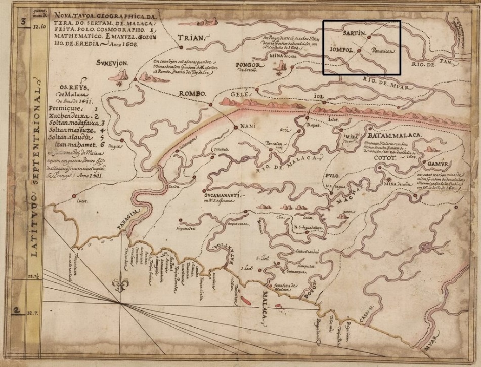
For cartography material on this thesis, the figures
Findings
Mapping by the western cartographers in the ancient and medieval era has left us with historical bits and pieces clue on the earliest discovery of the Malay Peninsula. When Ptolemy started to cartograph the Southeast Asia, it was an event of expanding an empire of Alexander the great in the mid of the 1st century A. D. Whether Ptolemy himself has reach the River Muar cannot be confirmed by any of authors cited above. Assumptions were done based on surviving maps some archived at University Malaya to understand the point of attention of the European cartographers to come and explore the Malay Peninsula even in ancient times. Findings in mapping evolution of Jalan Penarikan shows that it (the trans peninsula route via Jalan Penarikan) was described from the 1st century and repeated with errors but later been rectifies after more than a millennium. No early maps by local cartographers were found in this study which increases the curiosity why.
Textual data on the other hand proves to be less in amount especially for Jalan Penarikan but the accuracy of its facts remains definite. European writers tend to describe mostly on the item of trading with the east whereas writing by local authors mainly focuses on the war and royal family affairs. Dates of events can be found often to show the chronological history.
Conclusion
It is interesting to know the fact that Jalan Penarikan has been active for centuries, but the question why it is not written in history of its glory and technology can only be concluded to, first, because it is mainly used by the locals in trading and the for government of Pahang, Malacca and Negeri Sembilan to mobilize their administrative and defensive personnel and merchandise. Second, when it is written by European cartographers, they were only here for a short period of time and most of their trading activity in on the shoreline of the Malay Peninsula thus limiting their knowledge of Jalan Penarikan. Third, record of textual data proves that European ships may only enter Muar-Pahang riverine route only if they were escorted by locals of the government. The Portuguese warn other explorer in their journal saying, ‘do not enter this channel’ as a stern warning of the danger of being ambush on the river. On the note, high possibility that Jalan Penarikan has always been administered by the local government thus its secrecy was the priority.
References
- Adil, B. (1971). Sejarah Johor. Kuala Lumpur: Dewan Bahasa dan Pustaka.
- Adil, B. (1972). Sejarah Pahang. Kuala Lumpur: Dewan Bahasa dan Pustaka.
- Asyaari Muhammad, N. M. H., Nik Hassan Shuhaimi. (2007). Penyelidikan Laluan Penarikan Muar-Pekan. Alam Tamadun Melayu UKM (ATMA), 287-304.
- Borschberg, P. (2010). The Singapore and Melaka Straits (1st ed.). Singapore: NUS Press Singapore.
- Braddell, S. R. (1936). An Introduction To The Study Of Ancient Times In The Malay Peninsula And The Straits Of Malacca on JSTOR. Journal of The Malayan Branch of The Royal Asiatic Society, 1.
- Desceliers, P. (Cartographer). (1545, 1550, 1553). Manuscript world chart.
- Desliens, N. (Cartographer). (1541). Manuscript world chart.
- Muzzi, G. A. (2011). The Portuguese in Malay Land: Edições Vercial.
- Reinel, P. e. J. (1519). Portuguese Navigation. 2002, from http://cvc.instituto-camoes.pt/navegaport/g36.html
- Tsukasa, O. (1852). Malay Local Society in the Pre-Colonial Period. Journal of The Malayan Branch of The Royal Asiatic Society, vi.
- Wheatley, P. (1955). The Malay Peninsula as known to the Chinese of the Third Century A.D. Journal of The Malayan Branch of The Royal Asiatic Society, 28(1 (169)), 23.
- Wheatley, P. (1957). Possible References to the Malay Peninsula in the Annals of the Former Han on JSTOR. Journal of The Malayan Branch of The Royal Asiatic Society, Vol. 30(No. 1 (177)), 115-121.
- Wheatley, P. (1961). The Golden Khersonese: University of Malaya Press
Copyright information

This work is licensed under a Creative Commons Attribution-NonCommercial-NoDerivatives 4.0 International License.
About this article
Publication Date
01 May 2018
Article Doi
eBook ISBN
978-1-80296-039-6
Publisher
Future Academy
Volume
40
Print ISBN (optional)
-
Edition Number
1st Edition
Pages
1-1231
Subjects
Business, innovation, sustainability, environment, green business, environmental issues
Cite this article as:
Abidin, M. Z., Ibrahim, N., Muhammad, A., & Surat, M. (2018). Analysis Of Alternative Trade Route Based On Earliest Cartography And Textual Data. In M. Imran Qureshi (Ed.), Technology & Society: A Multidisciplinary Pathway for Sustainable Development, vol 40. European Proceedings of Social and Behavioural Sciences (pp. 551-562). Future Academy. https://doi.org/10.15405/epsbs.2018.05.43