
Historic Building Information Modelling (Hbim): A Review

Abstract
Historic Building Information Modelling (HBIM) is a novel technology that can be used to manage heritage and historical buildings. As capturing and modelling the heritage environment is often challenging and time consuming, this new method is an emerging solution to overcome such problems. Although HBIM is a promising innovation, the research into this technology is still inadequate, particularly in Malaysia. In an attempt to expand this field, the paper aims to discuss the workflow, the benefits and future research directions for HBIM. Through extensive literature reviews, the first part will discuss the process of HBIM; while the second part will highlight the recent developments of HBIM to provide an insight on the application and its advantages. From the study, the workflow can be categorized into three major steps; Data Acquisition, Data processing and 3D modelling. In addition, twelve (12) case studies of BIM applications in the area of cultural heritage were reported. It can be concluded that the incorporation of BIM with historical built environments led to the development of Building Performance Analysis, Structural Analysis, Facility Management, Augmented Reality, Virtual Reality and Fire Safety Design for existing buildings. Findings intend to expand the information and bring forward the potentials of BIM in documenting cultural heritage buildings in Malaysia.
Keywords: HBIM, heritage building, 3d modelling, heritage documentation
Introduction
In recent years, Building Information Modelling (BIM) has become a topic of great interest and widely recognised across the Architectural, Engineering and Construction (AEC) sector due to its capabilities. Generally, BIM can be defined as a process of managing the building information throughout its lifecycle (Fonnet, Alves, Sousa, Guevara, & Magalhães, 2017) which consists of components represented by parametric objects (Dore & Murphy, 2012). The technology allows the production of economic schedules, structural analysis and energy efficiency of a building (Dore & Murphy, 2012) which can be useful to the construction industry players. The approach shows potential measures to a) reduce the construction cost while at the same time b) increasing the quality of works (Ashcraft, 2008). Due to these benefits, BIM application is further extended and applied to the existing buildings. Since the platform is one of the most reliable methods for building documentation, it ultimately broaden up the possibility of using BIM in historical and heritage environment. As the research into this matter has been growing for several years, a number of approaches have been proposed including Historic Building Information Modelling (HBIM). HBIM is a technology with a focus on developing new methods to manage historical buildings and the innovation has been in a positive development since its first introduction by Murphy, McGovern, and Pavia, (2009). The technology demonstrates huge potential and expected to transform the architectural heritage industry to the next level. According to Dore and Murphy (2012), the technology is a plug-in for BIM which consists of parametric objects that were reconstructed from historic data (i.e. books and literature). With this information, HBIM typically can be used for renovation, maintenance, as built drawings and conservation projects. Furthermore, in order to be useful to the heritage professionals, the platform enables the user to create a detailed three-dimensional (3D) model with historical, construction and materials information embedded in it.
Problem Statement
The use of HBIM in the industry is now further extended to offers new opportunities and effective solution to overcome the challenges or issues during documentation of historic buildings. However, despite the worldwide development of HBIM, the research into this technology is still inadequate and limited, particularly in Malaysia. The methodologies need to be deeper investigated and discussed as historical buildings are always associated with irregular and complex forms.
Research Questions
How can this new technology be useful to the local industry and what are the workflow, challenges and benefits of HBIM?
Purpose of the Study
The study aims to highlight the process and benefits of HBIM to encourage its implementation in the local AEC practice. Indeed, there are needs to adopt new method in preserving heritage buildings and HBIM is one of the approaches to ensure the historical inputs are precise and does not lose its value.
Research Methods
Through extensive literature reviews, the study presents the application of HBIM that will focus on its process and advantages. Data used in this study consists of secondary data sourced from scientific journals and conference proceedings. The Google’s Scholar search engine was used to locate the materials using the keywords of; “HBIM”, “BIM Heritage”, “HBIM Advantages” and “HBIM Malaysia”. To provide an insight on the application and its advantages, the first part of this study will discuss the process and workflow of HBIM while the second part will highlight the recent developments and the benefits of HBIM.
Findings
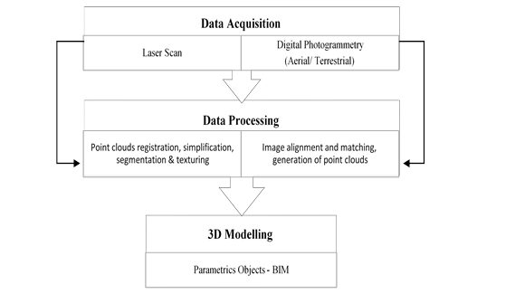
The process of this new technology involves several stages and it starts with the collection of survey data using terrestrial laser scanning (TLS) or digital photogrammetry to capture the surface of the buildings (Dore & Murphy, 2012; Garagnani, 2013; Fregonese et al., 2015; Barazzetti et al., 2015). As heritage documentation requires a certain levels of details to represent the authenticity of a building, laser scanning is widely chosen due to its precise and accurate geometric reproduction. This technology is therefore suitable to record irregular shapes of an object. Consequently, the captured data can be used to generate parametric objects for BIM (Nieto, Moyano, Rico Delgado, & Antón García, 2016). Nowadays, as mentioned by Baik and Boehm (2015), the laser scanning features have been well developed, and the most chosen brands are Faro, Trimble and Leica. However, important considerations have to be pointed out; the laser scanners are often subjected to several issues such as cost consuming, fragile setup and the technique is not well suited for transparent, reflective or dark objects (Bruno, De Fino, & Fatiguso, 2016). Hence, the scanning process should be planned carefully to avoid incomplete data acquisition.
Alternatively, to achieve more complete result, laser scanning can also be integrated with digital photogrammetry (Brumana et al., 2017). The technique is basically a process of generating geometric information of an object through photographs (Klein, Li, & Becerik-Gerber, 2012). Currently, Unmanned Aerial Vehicle (UAV) or drone has been selected for aerial photogrammetry due to its capability to cover the upper parts of the building or any inaccessible location. A detailed review on this application can be found in related literatures by Oreni, Brumana, Della Torre, Banfi, and Previtali, (2014), Chiabrando, Sammartano, and Spanò, (2016) and Aicardi et al., (2016). After the scanning process (laser scan or digital photogrammetry), a number of data processing is conducted to generate triangulation mesh. For TLS survey, the steps involved point clouds registration, simplification, segmentation and texturing (Dore & Murphy, 2012). In this sense, the resulting point cloud retrieved from the acquisition process needs to be cleaned from unnecessary data before the 3D modelling takes place. As for digital photogrammetry, data processing is essential (Siebert & Teizer, 2014). Some of the commercial software used in this step includes Autodesk Recap, Agisoft Photoscan, 3Df Zephyr and Pix4D, to name a few. Although the software tools differ in the algorithms (image processing and matching), Aicardi et al. (2016) pointed out that they all lead to the image alignment, creation of point clouds and the production of 3D mesh which can be used in the modelling process. Once the processing is completed, the next step refers to the modelling of the architectural elements by mapping the parametric objects to the point clouds (Dore & Murphy, 2012). In other words, the recorded information (point cloud) was used as a reference to reconstruct the components in 3D. The plan, elevation, and section views can be generated after the building has been digitally reconstructed in BIM environment. Furthermore, any alterations to building components in one of these views will be automatically updated in other views (Arayici, 2008) without having to redraw each one of them manually, ensuring the consistency of the information. To sum up, all of these HBIM workflow can be categorized into three major steps; Data Acquisition, Data processing and 3D Modelling. Figure 1 presents the workflow for all of these processes.
HBIM represents a new concept within AEC industry and it has the potential to benefit different parties including architects, conservators, historians, archaeologist, technicians and the public community. Many related works have shown the application and the advantages of using BIM for heritage buildings. One of the projects is the reconstruction of The Catholic Church of St. Maria by Brumana, Oreni, Raimondi, Georgopoulos, and Bregianni, (2013). The study suggested that the application of HBIM can assist in demonstrating the life cycle of the building, structural analysis as well as its chronological phases. Apart from that, Green Building Studio was integrated to perform Building Performance Analysis which is required for maintaining the heritage environments. A similar approach has been conducted by Zainudin, Haron, Bachek, and Jusoh, (2016), where the Traditional Malay House was reconstructed using BIM and the building performance was analysed in Autodesk Green Building Studio. The case studies concluded that the integration of BIM with the existing building can create a proper analysis to study energy efficiency.
Another example showing the benefit of HBIM is the modelling of the Castel Masegra and its integration with the Augmented Reality (mobile application) (Barazzetti et al., 2015). In this study, the researcher stated that the HBIM can generate virtual tours of a building and potentially be a solid tool for the conservation process using portable device. For this purpose, the finished BIM model was inspected with Autodesk A360 on a tablet and different group of users will have the opportunities to view the building in 2D and 3D. Furthermore, the information of the building can be retrieved using the BIMx application. However, the file needs to be converted to IFC format (ArchiCad) as the application cannot read Revit model. Due to the file exchange from Revit to ArchiCad, the original objects experienced some errors and loss of information. Similarly, the same issue happened with the third application which is the iVisit3D. In order to overcome the problem, the conversion was done using Rhinoceros. Although there are some challenges in creating augmented reality using HBIM, the integration between BIM and portable device is a promising technology and it could be the starting point for a new method of preservation and restoration. In similar case (Chiabrando et al., 2016), the usage of mobile and portable device was explored in the reconstruction of Valentino Castle in Turin. Apart from cultural tourism purposes, the system was developed to create convenient tools for the built environment players to manage heritage buildings.
Additionally, the HBIM system can be used for Facility Managements. As presented by Fassi, Achille, Mandelli, Rechichi, and Parri, (2015), the new facility management system was introduced to document all working phases and restoring activities for Milan’s Cathedral. According to them, the system was created to a) manage rapid changes in the structures, b) increase the real time communication between site works and the office and, c) increase the mobility of the system to encourage its application on site. As determined, the study aims to visualize the detailed models on the web, share information linked to the model conveniently using the web and keep track on the changes of the objects throughout the years. The system is currently used for maintenance activities both in fieldwork and office.
A further example is the establishment of Virtual Reality (VR) in the reconstruction of Tainan Confucian Temple and Qiu Lian-gung’s Mother Chastity Arch (Lin, 2017). The researcher focuses on the importance of VR in construction industry (e.g. inspection of defects) and in the field of education (virtual learning environment). In the study, the final HBIM model was transmitted to Fuzor VR Platform as it has better connection with the Revit software.
However, during the process, “the faces of polygon still need to be controlled for the 3D digital model in case of too many faces leading to uncertainty of transposition” (Lin, 2017, p.42). Despite the challenging process, the paper argued that this integration, will ultimately improve the management quality, academic world and heritage environment as a whole. One more case is the analysis of Fire Safety Design using automated procedures based on HBIM process. As presented by Frosini, Biagini, Capone, Donato, and Giusti, (2016), the HBIM model of The Command Pavilion, which belongs to the Italian historical cultural heritage, was analysed using Solibri Model Checker (SMC). The researcher pointed out that “the SMC software applies a “Quality Assurance” process for each element (for instance, data of the project, products and components, services, management, production and control processes) by verifying the element's compliance with specific requirements by means of pre-set rules” (Frosini et al., 2016, p.1). In this sense, the user of this software will be able to adjust the rules and create detailed analysis in accordance with regulatory requirements, which differ in each country. Moreover, the system is able to identify and analyse the possible escape routes and fire compartments in a building.
As presented in Table 1, HBIM application can be categorized and used for the following purposes:
- Building Performance Analysis : Energy Efficiency of the building (lighting/ ventilation)
- Facility Management: On site progress tracking can used for maintenance or renovation.
- Augmented Reality : Cultural tourism, virtual museum and preservation tools
- Structural Analysis : Examine the integrity and the chronological phase of the structure
- Fire Safety Design : Evaluation of fire safety requirements to maintain heritage buildings
- Virtual Reality : For inspection or virtual learning environment
Conclusion
Although the use of BIM for historical buildings is still difficult and challenging, a positive growth can be seen in the continuous development of this new technique by researchers all over the world. In Malaysia however, the research into HBIM is still limited. As the concept of HBIM is still new to the industry, only a small number of works were identified in the literature. One of the projects is the analysis of building performance of Traditional Malay House using BIM (Zainudin, Haron, Bachek, & Jusoh, 2016), while its application to study the level of development and usage of BIM in heritage building is further discussed by Ali, Ismail, Hashim, Suhaimi, and Mustafa, (2018). Thus, in an effort to expand and promote HBIM to a wider community, the paper presents a review of the HBIM application and aims at illustrating its benefits in the field of cultural heritage documentation. The literature review revealed that the process of HBIM can be classified into three stages; Data Acquisition, Data Processing, and 3D Modelling. In addition, twelve (12) case studies of BIM applications in the area of cultural heritage were reported. From these projects, it can be concluded that HBIM led to the development and the improvement of Building Performance Analysis, Structural Analysis, Facility Management, Augmented Reality, Virtual Reality and Fire Safety Design for existing buildings. For future development in this area, the research will focus on the open source software that can be used to generate the platform. Additionally, in order to be globally competitive, visualization technology (augmented / virtual reality) for the public and students will be looking into details to introduce more interactive physical-visual interaction and it might contribute to improving society’s understanding of architectural heritage.
References
Aicardi, I., Chiabrando, F., Grasso, N., Lingua, A. M., Noardo, F., & Spanò, A. (2016). Uav Photogrammetry with Oblique Images: First Analysis on Data Acquisition and Processing. International Archives of the Photogrammetry, Remote Sensing & Spatial Information Sciences, 41.
Ali, M., Ismail, K. M., Hashim, K. S. H. Y., Suhaimi, S., & Mustafa, M. H. (2018). Heritage Building Preservation through Building Information Modelling: Reviving Cultural Values through Level Of Development Exploration. Planning Malaysia Journal, 16(6).
Arayici, Y. (2008). Towards building information modelling for existing structures. Structural Survey, 26(3), 210-222.
Ashcraft, H. W. (2008). Building information modeling: a framework for collaboration. Constr. Law., 28, 5.
Baik, A., & Boehm, J. (2015, October). Building information modelling for historical building Historic Jeddah-Saudi Arabia. In 2015 Digital Heritage (Vol. 2, pp. 125-128). IEEE.
Barazzetti, L., Banfi, F., Brumana, R., Oreni, D., Previtali, M., & Roncoroni, F. (2015). HBIM and augmented information: towards a wider user community of image and range-based reconstructions.
Bolognesi, C. E. C. I. L. I. A., & Garagnani, S. (2018). From a point cloud survey to a mass 3d modelling: renaissance hbim in poggio a caiano. International Archives of the Photogrammetry, Remote Sensing & Spatial Information Sciences, 42(2).
Brumana, R., Oreni, D., Raimondi, A., Georgopoulos, A., & Bregianni, A. (2013, October). From survey to HBIM for documentation, dissemination and management of built heritage: The case study of St. Maria in Scaria d'Intelvi. In 2013 Digital Heritage International Congress (DigitalHeritage)(Vol. 1, pp. 497-504). IEEE.
Brumana, R., Dellatorre, S., Oreni, D., Previtali, M., Cantini, L., Barazzetti, L., ... & Banfi, F. (2017). HBIM challenge among the paradigm of complexity, tools and preservation: the Basilica di Collemaggio 8 years after the earthquake (L'Aquila).
Bruno, S., De Fino, M., & Fatiguso, F. (2016). HBIM-aided refurbishment process of Cultural Heritage. ISTeA-BACK TO, 4, 60-69.
Chiabrando, F., Sammartano, G., & Spanò, A. (2016). Historical buildings models and their handling via 3D survey: from points clouds to user-oriented HBIM. International Archives of the Photogrammetry, Remote Sensing & Spatial Information Sciences, 41.
Dore, C., & Murphy, M. (2012, September). Integration of Historic Building Information Modeling (HBIM) and 3D GIS for recording and managing cultural heritage sites. In 2012 18th International Conference on Virtual Systems and Multimedia(pp. 369-376). IEEE.
Fassi, F., Achille, C., Mandelli, A., Rechichi, F., & Parri, S. (2015). a New Idea of Bim System for Visualization, Web Sharing and Using Huge Complex 3d Models for Facility Management. In 6th International Workshop on 3D Virtual Reconstruction and Visualization of Complex Architectures, 3D-ARCH 2015 (pp. 359-366). D. Gonzalez-Aguilera, F. Remondino, J. Boehm, T. Kersten, and T. Fuse.
Fonnet, A., Alves, N., Sousa, N., Guevara, M., & Magalhães, L. (2017, October). Heritage BIM integration with mixed reality for building preventive maintenance. In 2017 24º Encontro Português de Computação Gráfica e Interação (EPCGI) (pp. 1-7). IEEE.
Fregonese, L., Achille, C., Adami, A., Fassi, F., Spezzoni, A., & Taffurelli, L. (2015). BIM: An integrated model for planned and preventive maintenance of architectural heritage. In 2015 Digital Heritage (Vol. 2, pp. 77-80). IEEE.
Frosini, G., Biagini, C., Capone, P., Donato, V., & Giusti, T. (2016). HBIM and fire prevention in historical building heritage management. In ISARC. Proceedings of the International Symposium on Automation and Robotics in Construction (Vol. 33, p. 1). Vilnius Gediminas Technical University, Department of Construction Economics & Property.
Garagnani, S. (2013). Building Information Modeling and real world knowledge: A methodological approach to accurate semantic documentation for the built environment. In 2013 Digital Heritage International Congress (DigitalHeritage) (Vol. 1, pp. 489-496). IEEE..
Klein, L., Li, N., & Becerik-Gerber, B. (2012). Imaged-based verification of as-built documentation of operational buildings. Automation in Construction, 21, 161-171.
Lin, Y. C. (2017). Application of Integration of HBIM and VR Technology to 3D Immersive Digital Management--Take Han Type Traditional Architecture as an Example. International Archives of the Photogrammetry, Remote Sensing & Spatial Information Sciences, 42.
Murphy, M., McGovern, E., & Pavia, S. (2009). Historic building information modelling (HBIM). Structural Survey, 27(4), 311-327.
Nieto, J. E., Moyano, J. J., Rico Delgado, F., & Antón García, D. (2016). Management of built heritage via HBIM Project: A case of study of flooring and tiling. Virtual Archaeology Review, 7(14), 1-12.
Oreni, D., Brumana, R., Della Torre, S., Banfi, F., & Previtali, M. (2014). Survey turned into HBIM: the restoration and the work involved concerning the Basilica di Collemaggio after the earthquake (L'Aquila). ISPRS Annals of the Photogrammetry, Remote Sensing and Spatial Information Sciences, 2(5), 267.
Palestini, C., Basso, A., & Graziani, L. (2018). Integrated photogrammetric survey and bim modelling for the protection of school heritage, applications on a case study. International Archives of the Photogrammetry, Remote Sensing & Spatial Information Sciences, 42(2).
Quattrini, R., Battini, C., & Mammoli, R. (2018). Hbim to vr. Semantic awareness and data enrichment interoperability for parametric libraries of historical architecture. International Archives of the Photogrammetry, Remote Sensing & Spatial Information Sciences, 42(2).
Siebert, S., & Teizer, J. (2014). Mobile 3D mapping for surveying earthwork projects using an Unmanned Aerial Vehicle (UAV) system. Automation in construction, 41, 1-14.
Zainudin, H., Haron, N. A., Bachek, S. H., & Jusoh, A. (2016, October). Utilization of building information modeling (BIM) in planning an adaptive reuse project of a Traditional Malay House (TMH). In 2016 22nd International Conference on Virtual System & Multimedia (VSMM) (pp. 1-7). IEEE.
Copyright information

This work is licensed under a Creative Commons Attribution-NonCommercial-NoDerivatives 4.0 International License.
About this article
Publication Date
26 December 2017
Article Doi
eBook ISBN
978-1-80296-950-4
Publisher
Future Academy
Volume
2
Print ISBN (optional)
-
Edition Number
1st Edition
Pages
1-882
Subjects
Technology, smart cities, digital construction, industrial revolution 4.0, wellbeing & social resilience, economic resilience, environmental resilience
Cite this article as:
Kamaruzaman*, N. U. S. N. (2017). Historic Building Information Modelling (Hbim): A Review. In P. A. J. Wahid, P. I. D. A. Aziz Abdul Samad, P. D. S. Sheikh Ahmad, & A. P. D. P. Pujinda (Eds.), Carving The Future Built Environment: Environmental, Economic And Social Resilience, vol 2. European Proceedings of Multidisciplinary Sciences (pp. 587-594). Future Academy. https://doi.org/10.15405/epms.2019.12.58