
Expecting The Unexpected: Climate Resilience In Malaysian Local Government Land Use Planning

Abstract
A resilient city will strive from stress driven by climate change and play pivotal role in climate adaptation initiatives. Thus, it is imperative that the Local Government of cities as the urban managers and city planners to effectively mainstream climate resilience adaptation in the planning processes of the local government. The aim of this research is to understand and explore the challenges faced by the Malaysian Local Government, particularly Land Use Planning (LUP) in Penang adapting to climate change. Secondly, it is to identify key defining changes needed in LUP to facilitate climate resilience adaptation. A multi method approach was used to gather data: four sessions of focus group discussion were carried out encompassing officers from the planning department of the local government, state and federal government officers, representatives from the property developers’ association, civil societies and representatives from a local university. Two sessions of interviews were also conducted with policy makers. Results implore four imperative challenges that post bigger opportunities for change including leadership on sustainable development, reliability and collation of spatial and non-spatial data, the need for transdisciplinary planning team and a climate proof land use planning approach. The findings are a steppingstone in determining the priority of LUP for the next few decades but also the physical parameter of growth of Penang.
Keywords: Climate resilience, land use planning, local government, qualitative research
Introduction
Climate-resilient pathways are defined as sustainable development trajectories that combine adaptation and mitigation to reduce climate change and its impacts (Eriksen, Håkon Inderberg, & Sygna, 2015). These are seen as iterative and evolving processes for managing adaptation to change within complex local government systems as the city planners and urban managers. More importantly, they draw attention to the need for transformative responses, rather than merely a continuation of ‘business-as-usual’ ones. Thus, Local Governments play imperative roles in ensuring resilience: effective climate mitigation (the ability to “return to normal” by effective coping with negative such as disasters), long term adaptation (the ability to adapt to new norms effectively) plans and creative transformation (the ability to shift to accommodate radical shifts beyond the tipping point in environmental or economic conditions) initiatives. Besides that, current trends in urban growth and resource intensification are also expected to accelerate over the coming decades, especially in east and south-east Asia (UNFCC: Learn) and as such, the interest on climate change has gained attention of the people and government of Malaysia. This is due to abnormal weather patterns such as increase in mean surface temperature, 0.6°C to 1.2°C from 1969 to 2009 (Met Malaysia), increased rainfall intensity with an hour rainfall intensity from 2000 - 2007 increase by 17% compared to 1970s values (NAHRIM), sea level rise from 4.6 cm to 11.9 cm based on satellite altimetry data observed from 1993 to 2010 (NAHRIM).
Land use planning in Penang
Land use planning is both a challenge and opportunity for nations in adapting sustainable developments especially by the industrial 4.0 revolution that is already shaking up many industries and nations (Simon & Leck, 2015). The perpetual landscape of land use is dynamic and it may reflect the transformation of a city influenced by underlying economic and sociocultural urban advancement which indirectly affects the sustainability of rural authenticity. There is always increased competition as well as demand for land for diverse purposes as developing countries continue to expand urban hubs to become large metropolitan areas. This requires adequate planning and control to ensure sustainable development and functional efficiency of these uses and settlements.
Malaysia principally adopts a top to bottom approach where the authorised agencies will complete the planning and publish it for the reference by related agencies and interested parties in the planning process. The National Physical Plan, also known as ‘Rancangan Fizikal Negara’ (RFN), will reflect the nation’s goal in terms of land planning and development. State planning or the ‘Rancangan Struktur Negeri Pulau Pinang (RSNPP)’ will be guided by the RFN and Local Plan or ‘Rancangan Tempatan (RT)’ will then refer to the RSN. The sequence of the planning process is detailed in Figure 1 below:
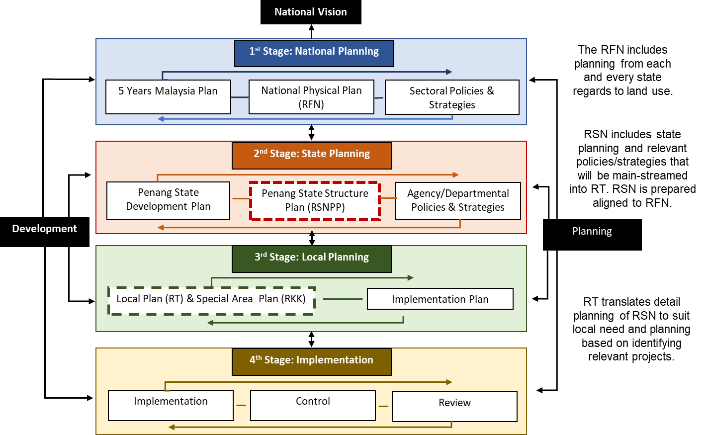
Under the 172 Act, Plan Malaysia is accountable for managing the state spatial planning along with the local authorities such as the Local Governments known as ‘Pihak Berkuasa Tempatan’, State Economic Planning Division (BPEN), District and Land Offices (PDT), Public Works Department (PWD), Department of Irrigation and Drainage (JPS), Department of Agriculture and Department of Environment. Each related agency however is required to comply with the planning and goals stated in the RFN and currently, we are referring to the RFN3. The RFN was planned by the National Physical Planning Council or known as ‘Majlis Perancang Fizikal Negara’ (MPFN) which is responsible for ensuring that the planning and resources used is well-balanced and sustainable on state and country level (Jabatan Perancang Bandar dan Desa, 2018). The RSN on the state level will plan the state activities and development based on decisions stipulated in the RFN. In the structure plan, related agencies will device the planning by taking into account the important key sectors. The urban and physical boundary of an area needs to be identified and utilised in the structure plan and this established development of different areas should act as the base to create a comprehensive development corridor in Penang.
In planning, proper zoning and plot ratio density will be incorporated during the planning permission stage (While & Whitehead, 2013). In addition, projection and simulation was used in the planning and it was utilised as one of the indicators. In Penang specifically, the planning has to include importance of preserving the heritage and culture value cherished by the citizens. There are also guidelines in place meant to improve land use. E.g. in Penang the guideline for Transit Oriented Development has already been included in the Draft Local Plan (DRT). However, since the local planning is not yet gazetted, the DRT content could not be included in this report. In addition, the Special Area Planning or ‘Rancangan Kawasan Khas - RKK’ (SAP) acts as a detailed planning guideline that caters to the uniqueness of a certain area to ensure its preservation in Penang. Currently, RKK Taman Botani, RKK Bukit Bendera and RKK Tapak Warisan Dunia George Town are in the process of being gazetted. In addition, Rancangan Struktur Negeri Pulau Pinang (RSNPP) or the State Structure Plan is a written document consisting of strategic planning principles and proposals on land use development while providing Penang with directions on how to move forward. The first RSNPP known as the RSNPP 2020 was gazetted in 2007. This planning also ensures that sensitive areas such as slope are protected and under controlled development. However, ever increasing development pressure is mounting on our environmentally sensitive areas in particular hill land and slopes in recent years. In improving the existing RSNPP, Plan Malaysia along with related agencies have prepared the RSNPP2030 that was intended to drive Penang towards a sustainable, competitive and high-income economy. This is also because Penang is seen as a high-income state that needs to come up with a holistic well-prepared plan for the future. The publicity and public participation process for the RSNPP was held for two months giving the public more than ample time to suggest and review the report. This is in line with the requirement in Act 172 (section 9) where the public is given the opportunity to contribute towards the planning. The latest amendment in Act 172 also required that Social Impact Assessment (SIA) has to be submitted during the planning permission stage as well.
Problem Statement
As the world braces for further alterations caused by anthropogenic and natural evolution, land use planning is a persistent challenge and opportunity for nations in adapting sustainable developments (Simon & Leck, 2015). As such, to effectively respond to the increasing climate change impacts such as loss of livelihoods, homes and lives particularly those of vulnerable coastal communities which are increasingly threatened, it is imperative for the Malaysian government to not only mitigate but also to adapt climate change resilience at the local level. This is because, as the effects of climate change are felt locally, planning and monetary decisions are often made at the local level and climate change impacts the services provided by the local government. To effectively respond and adapt to the increasing frequency of stress and shocks, the Malaysian Local Government as the Urban Managers/City Planners must effectively mainstream climate change resilience adaptation in the planning processes of the local government.
The aim of this research is to understand and explore, opportunities and challenges faced by Malaysian Local Governments to climate change adaptation with regard to land use planning processes. Effective operationalisation of mainstreaming measures summarized into three capacity classifications institutional, information, and resource capacities which can be represented either as barriers or opportunities to successfully adapt resilience in cities. And when transformed as indicators, mainstreaming can effectively assess the conditions surrounding the process of mainstreaming Climate Resilience into the local land use plans in Penang Malaysia.
Research Questions
The world’s population is increasingly concentrated in large cities due to rapid urbanisation, (UNISDR, 2012), and excessive unplanned and unregulated urban growth will lead to various vulnerabilities resulting in economic, physical and social impact. As such, it's highly detrimental when impacts of climate change: such as natural disasters occur in urban environments. Therefore, it is imperative to increase resilience of cities to climate change by strengthening the urban city systems. UNISDR (n.d.) has also specifically addressed the 2011 world disaster risk reduction campaign for local governments under the theme: Making Cities Resilient – My City is Getting Ready. This was further supported by Mayana (2006) that the development of disaster resilience by local authorities is largely dependent on the capacities of the local authorities to plan and manage the development activities which clearly strengthens the researches argument of the importance for empowering local government.
Much research also has been undertaken on making cities resilient in terms of the role of local government in climate change impact especially in context of disaster risk reduction. However, there is a gap in research that has yet to address on how local governments can lead in making cities resilient to climate change by implementation and adapting successfully climate change resilient initiatives in their respective areas. Hence there is a need to undertake a research on how local governments can incorporate climate resilience by reforming the planning processes in the existing governance structure which eventually will contribute to the main aim of this research that is to develop a framework to enable Malaysia Local Governments to make cities climate resilient based on planning context – Local Plan.
The objectives of this research will be explored by way of seeking answers to the following research questions:
- What are the challenges/weaknesses of the existing Local Plan process/governance structure in making climate resilient cities?
- How local governments can lead in making cities adapt to climate change within the context of local planning?
- How could the Local Plan processes be restructured to ensure the climate change resilient initiatives be institutionalised and main streamed effectively?
Purpose of the Study
The main focus of this research is to increase the efficiency of the land use planning in order to accommodate the rapid urbanisation, focusing on Penang. Among the issues that the research will look at are basic assumptions and approaches for sustainable land use planning, the issue of land use efficiency, governance innovation as well as the role of land use in promoting green economy in Penang. The key objectives which this study seeks to address are:
- To identify the challenges/weaknesses of the existing Local Plan Process/governance structure in making climate resilient cities;
- To investigate climate resilient management process, from both institutional and government perspective;
- To investigate the present state of land use planning and the institutional conditions that shape planning decisions related to climate resilience in Malaysia.
Research Methods
A research is a systematic and methodical process of enquiry and investigation with a view of increasing the knowledge domain (Collis & Hussey, 2009) and it is important to find an acceptable focus for the study which in turn requires continuous focusing and re-focusing (Easterby-Smith, Golden-Biddle, & Locke, 2008). And as such, it important for a researcher to choose an area of study that matches the researchers' strength and interest (Saunders, Lewis, & Thornhill, 2009) in order to focus and re-focus to enhance the knowledge domain. Thus, the subject area of interest for this research is derived from the researcher's own work experience in the Malaysia local government and passion to ‘make cities climate resilient’.
In addition to that, through initial literature review the researcher was able to establish the research problem, aim and objectives which were further fine-tuned based on expert opinion. Two unstructured interviews were carried out with two experts; one interviewee is a city planner in the government Planning Department focusing on Local Plan procedures as well as processes and, the other is an urban conservationist, an expert in climate resilient initiatives, to refine and reflect relevance in the research undertaken by the researcher. The research applies interpretation as the philosophy and theoretical underpinning with the main aim to develop a framework in enabling local government to adapt to climate change resilience within the context of local planning which is complex and cannot be theorised by definite laws as physical sciences (Saunders et al., 2009). Two important research principles were also referred to for this research where the conceptual phase (theoretical) of the research process is explanatory science, that is to develop valid knowledge to understand the social world or to describe, explain and predict the existing state of the social world (Aken, 2005). The recommendation phase of the research is design science where the main aim of the research is to develop a framework that could be used by the local government for solutions in terms of addressing challenges incorporating climate resilience. Besides that, the researcher also used the funnel approach (Berthon, Nairn, & Money, 2003) in the exploration process of the research as it is likely to a bird's eye scanning – the process before grasping onto specific details of the research. And therefore, the researcher chose the qualitative approach for conducting this research.
The nature of the research aims, objectives, and the research questions lead to the selection of the multiple-case holistic case studies as the most appropriate research strategy. The research evaluates and analyses the capacity of the local government in the mainstreaming climate resilience to the land use planning process. As the research does not try to observe changes and the development of a phenomenon or phenomena over a period of time, from the time horizon perspective, it is accordingly considered as a cross-sectional study. In additional, the researcher collected the secondary data from documents and archival records, including reports, journals, and standards related to the focus of the study. The primary data was collected from four Focus Group Discussions (focus on lower and middle management level) with the representatives of the government bodies at the national, state and local government level, civil societies (including NGO), field experts, professional bodies, business representatives as well as consultants from private sectors. The findings were validated by two semi-structured interviews with policy makers: state executive councillors. For the analysis of focus group discussions and semi-structured interview data, content analysis as well as cognitive mapping methods will be used with the aid of the computer-aided software ATLAS.ti 8.
Findings
The research identified several challenges in land use planning in Penang. State and local government authorities need to address these issues in order to increase land use efficiency in the future. Challenges listed below are separated into: (1) structural, referring to issues that are directly related to the government and (2) non-structural will highlight the rest of the issues.
Public Participant
Participatory governance and deepening citizen participation in the governmental process which also visualises a genuine democracy are still lacking in this state. It is also a problem to ensure a legitimate representation from the public to be involved in the process while at the same time to ensure that it is not dominated by a small group of people who are more vocal than the rest. Current engagement can be improved in order to increase public participation. Certain efforts also must be made such as making sure that approach taken is not too technical to be understand by the public, to involve specialists in the process and to increase public awareness and knowledge. Another aspect to consider is that the government representative is accountable to their statement and sometimes need to make difficult choices that may not be supported by a particular group of people. Another factor to be taken into consideration is the cost that agencies have to bear for the public consultation process. At the core of the issue is the current development plan (RFN, RSN, RTD, and SAP) processes whereby it incorporates only a small percentage of public feedback compared to other stakeholders (e.g. professional bodies, industry players etc). As an example, public feedback in Penang was most sought for the George Town UNESCO area, while at the pre-submission stage, RT and SAP were not widely utilised. At present, there are two stages of public consultation involved in preparing the development plan (RFN, RSN, RT, SAP). The first stage involves gathering opinion from targeted groups and people on the ground.
Collaboration
Collaboration on plan drafting and finalisation for RT, RT, RFN and SAP, the consultant and planners registered with Ministry of Finance can bid for tender open by the government. The winning company will have to complete the planning while working with the related agency. During the process, all listed below will participate in the process. Currently, academicians and professional bodies are able to be involved during the public participation process only. However, there is a need to include them throughout the whole process especially at the initial stage i.e. while preparing the draft, as this finally becomes the adopted framework. Stakeholders will be called in during the draft preparation for a “focus group discussion” and the discussion varies in terms of knowledge and expertise (e.g. politician, academician etc.). Such a situation creates further anxiety and inconclusive adaptations of the entire proposal. There is also the involvement of the technical working group according to sectors (e.g. housing, flood). Nevertheless, involvement of civil society is much needed and will help to improve the process and enhance the output exponentially.
Information (Data)
State requires digital blueprint that governs the whole state of what is existing on and under the soil surface if a disaster occur. The land and underground mapping will provide all the necessary information in order to have an efficient procedure during disaster. A comprehensive blueprint will help tremendously in the planning and development process. Currently, the data needed is available in each respective agency; however, the issues are kept with the data ‘custodian’ who is in charge of collecting, storing and sharing the data. The technology and process involved in developing and maintaining the blueprint is very costly. On another note, restricted knowledge of a specialist in certain areas will limit the usage of relevant data. Concurrently, materials completed for public interest need a user-friendly interface for a two-way communication to be established. Access to a wide-ranging data set (including socio-economic) is crucial in order to allow planners and decision-makers to make informed decision. Nevertheless, the ability to such data is sometimes cumbersome and outdated which makes the process slow and obsolete at certain intervals.
Laws and Regulations
Planners and local governments are guided by Act 172 and some other by-laws that guide them in managing and planning the development in Penang. However, the current planning system is reactive rather than proactive and this leaves some room for it being led by interested parties. In this matter, rules and regulations should be reviewed and revised so that they don’t become outdated. Incorporation of best practices is very much needed, however, reforming the act and by-laws will need strong commitment and efforts. Development plans currently (RFN, RSN, RT and SAP) are reviewed every five years which ensure that public engagement is made every 5 years. Current laws and regulations should allow forward-looking planning. However, certain current by-laws do not cater to it (e.g. smart buildings). Content of by-laws can be changed by the federal government and under Act 176; local authorities can make by-laws. There are a number of climate change, water saving, waste management and green building related by-laws existing in Penang. The Federal government is in the midst of drafting a resilience/disaster risk management plan for the whole of Malaysia which will be implemented throughout the country once it is approved by the state and local authorities. Besides that, the Environmental Impact Assessment (EIA) is a good tool for improvement that should be independently prepared instead of done by consultants that were hired by the developers. The Local government needs a capable sustainability officer to assess the sustainability of all programmes. Presently, project-based cumulative impact of development as a whole is not assessed by a competent officer. In addition to that, EIA is too technical for public to understand and this will limit their feedback towards the project.
Conclusion
As a result, in order to mainstream climate resilience in land use management and more importantly to create an expedient and conducive environment for present and future generations, there is a critical need for a more fundamental rethinking of land use control mechanisms, policy controls and stern action plans. The Government especially the Local Government as master land use planners must be well equipped and start planning for climate change and biodiversity sensitive development in order to minimise damage and ensure security in all aspect that matters. These include the need for cities/townships to strengthen their vibrant economic sectors to compete with progressive development and to mature with resilience towards potential future threats by addressing:
Effective collation of reliable data
At present, land use planning relies on various geo-spatial and non-geo-spatial data provided by various departments. Certain data may not be updated often or are even contradictory. Furthermore, not all relevant data pertinent to sustainable use of land is used for planning currently, such as vulnerability information and socio-economic conditions that may indicate how current land use impact on liveability. Continuous update and sharing of relevant data with the planning department is also a challenge. The availability and utilisation of quality data (accuracy, validity, reliability, timeliness, relevance and completeness) will have a huge impact on land use planning, especially if it is complemented through scenario modelling where different choices of land use are assessed in allowing policy makers to choose the most suitable ones for their locality. It is relatively easy to make sure each department keeps a set of reliable data and shares them with the planning department. An effective system needs to be in place to ensure records are maintained and available at any time of reference.
Leadership on sustainable and resilient development
The FGD members agreed that to mainstream the transition towards a more climate resilient oriented land use planning; the government needs leaders, not only through political party acquaintances but also government departments, to commit in achieving Sustainable Development Goals (SDGs) and empowering people through power of speech and opinions. This can be achieved by raising awareness and bridging clarity about the economic and social benefits of early transitions. There will be reservations and even pushbacks from certain quarters including decision-makers, but if a strong leadership on sustainable development is established across government departments, the impact on future land use will be immense as it can result in more forward-looking and balanced land use choices. In fact, the right leadership is ranked the greatest impact on land use planning, above and beyond all the other recommendations in the research.
A planning ream that is trans-disciplinary and consists of non-governmental entities
The team must include trans-disciplinary personnel with stakeholders from a range of background and not just planners. It should also consist of non-governmental entities or civil society to make sure that visionaries or experts not related to the government can contribute in designing development pathway. The team will work closely with staff from planning departments and the private consultants responsible for drafting the specific plan. With input from wide range of stakeholders, the process of land use planning would become more dynamic, inclusive and informed which in return will ensure current development does not compromise the needs of future generations’ wellbeing.
Climate resilient and biodiversity sensitive-proof planning
As climate change severely impacts the ecosystem and urban areas, any city or township is likely to suffer from more frequent and severe floods, sea level rise, storms, landslides and water and food insecurity. It is essential that the Local Government is prepared for the challenges through a forward-looking and resilience-focused land use planning. To reduce CO2 emissions, the Local Government should prioritise a public-transit oriented transportation growth model structure. In addition, having a detailed mapping of current and future vulnerability and disaster-prone areas will help identify suitable land use choices. More importantly, understanding the overall impact of the structure and local plans (and cumulative impact of individual development projects) through the use of Strategic Environmental Assessment (SEA) will permit the state to adopt a more proactive and scientific approach in making sure Penang enhances the maximum value out of its limited land availability. The research offers insights of challenges and opportunities to address climate resilient measures such as mainstreaming Climate Change Adaptation. It also helps the government to pave planners and decision makers ways to monitor the adaptation process and implementation, and also track the progress of adaptation efforts.
Acknowledgments
Financial support of the Malaysian Government Ph.D. Scholarship is gratefully acknowledged. Authors are also grateful to the anonymous referees for their insights on earlier drafts of this research.
References
Aken, J. E. (2005). Management Research as a Design Science: Articulating the Research Products of Mode 2 Knowledge Production in Management. British Journal of Management, 16(1), 19–36. DOI:
Berthon, P., Nairn, A., & Money, A. (2003). Through the Paradigm Funnel: A Conceptual Tool for Literature Analysis. Journal Marketing Education Review, 13, 55–66. DOI:
Collis, J., & Hussey, R. (2009). Business research: a practical guide for undergraduate and postgraduate students. Palgrave Macmillan. Retrieved from https://books.google.com.my/books/about/Business_Research.html?id=awLOPAAACAAJ&redir_esc=y
Easterby-Smith, M., Golden-Biddle, K., & Locke, K. (2008). Working with Pluralism Determining Quality in Qualitative Research. Organizational Research Methods Sage Publications, 11(3), 419 – 429. DOI:
Eriksen, S., Håkon Inderberg, T., & Sygna, L. (2015). Climate Change Adaptation and Development - Transforming Paradigms and Practices, Routledge 2015. From the NDF-financed publication, 1 – 12. Retrieved from http://www.ndf.fi/sites/ndf.fi/files/news_attach/climate_change_and_development.pdf
Jabatan Perancangan Bandar dan Desa Negeri Pulau Pinang. (2018). Rancangan Structur Negeri Pulau Pinang 2020. JBBD. Retrieved on 10 December 2018. <http://jpbdgeoportal.penang.gov.my/jpbd/RSN/>
Mayana, S. B. (2006). The concept of resilience revisited. Disasters, 30(4), 433-450. DOI:
Pusat Gedung Data Hidraulik Kebangsaan Malaysia (Gedung), Institut Penyelidikan Kebangsaan Malaysia. Retrieved on 10 December. <http://www.nahrim.gov.my/ms/produk/211-pusat-gedung-data-hidraulik-kebangsaan-malaysia-gedung.html>
Saunders, M. N. K., Lewis, P., & Thornhill, A. (2009). Research methods for business students. Prentice Hall. Retrieved from https://books.google.com.my/books?id=u-txtfaCFiEC&dq=saunders+2009&hl=en&sa=X&ved=0ahUKEwjKy63j7pDaAhWKRY8KHUrQBysQ6AEIKDAA
Simon, D., & Leck, H. (2015). Understanding Climate Adaptation and Transformation Challenges in Africa Cities, 109-116.
UNISDR, P. (n.d.). Malaysia - Asia - Countries & Regions - PreventionWeb.net. Retrieved from <https://www.preventionweb.net/english/countries/asia/mys/>
UNISDR. (2012). Making Cities Resilient Report 2012. Retrieved from https://www.unisdr.org/files/28240_rcreport.pdf
While, A., & Whitehead, M. (2013). Cities, Urbanisation and Climate Change, 1325-1331. Retrieved from DOI:
Copyright information

This work is licensed under a Creative Commons Attribution-NonCommercial-NoDerivatives 4.0 International License.
About this article
Publication Date
26 December 2017
Article Doi
eBook ISBN
978-1-80296-950-4
Publisher
Future Academy
Volume
2
Print ISBN (optional)
-
Edition Number
1st Edition
Pages
1-882
Subjects
Technology, smart cities, digital construction, industrial revolution 4.0, wellbeing & social resilience, economic resilience, environmental resilience
Cite this article as:
Kanasan*, V., & Hassan, S. (2017). Expecting The Unexpected: Climate Resilience In Malaysian Local Government Land Use Planning. In P. A. J. Wahid, P. I. D. A. Aziz Abdul Samad, P. D. S. Sheikh Ahmad, & A. P. D. P. Pujinda (Eds.), Carving The Future Built Environment: Environmental, Economic And Social Resilience, vol 2. European Proceedings of Multidisciplinary Sciences (pp. 189-199). Future Academy. https://doi.org/10.15405/epms.2019.12.19