
Flood Disaster Risk Assessment in Urban Morphology Framework to Enhance Resilience Factor

Abstract
The challenge of the city to face flood hazard is greater due to climate change and urbanization process. Community and economic activities will be centralized in prone areas, particularly in the new city in Asia and Africa which dominated by developing countries. Generally, urban planning in developing countries places less consideration on disaster risk factors. It will be repaired after a disaster arises with a high cost to fix it. Hence, Flood Disaster Risk Assessment (FDRA) is a progressive action in disaster mitigation to increase cities'preparedness. FDRA in disaster risk management framework will be conducted in the following steps: 1) risk identification; 2) risk analysis; and 3) risk evaluation. The result of FDRA is used to 1) determine the prone area; 2) a city's development priorities, and 3) adaptation improvement to enhance the resilience factor. This paper is a critical review of various approaches towards FDRA in urban morphology framework. The purpose is to develop guidance and tool of FDRA in urban disaster-risk management for reducing flood risk and enhancing risk knowledge. Discussions focus on driver of flood risk and urban morphology as basic of variable assessment of FDRA. Component of assessment divided into ecological, functional, economic, and spatial. An engineering approach is developed as FDRA tools and methodology.
Keywords: Flood disaster-risk assessment, flood risk, urban morphology, engineering approach
Introduction
Climate change has been giving a big challenge for an urban area to face uncertainty conditions because of hydrological hazards, such as floods, landslides, thunderstorms, hurricanes, tornados, etc, which rose significantly in the last twenty years. Climate-related disasters dominate the view of occurrences, reporting 91% of all 7.255 recorded between 1998-2017, which flood was the most frequent type of disasters, 43% of all record events (Centre for Research on the Epidemiology of Disasters (CRED), 2018; United Nations of Disasters Risk Reduction (UNISDR), 2004). Flood also impacted the largest number of people at more than two billion and caused 23% recorded economic loses (CRED 2018; UNISDR, 2004).
The challenge of the city to face flood hazard is greater due to the population of the city predicted to increase and reach 68% of the world's population in 2050 which adds 2.5 billion people in the city area and about 90% of the increase concentrated in Asia and Africa (Population Division of United Nations Department Economic and Social Affair (UN DESA), 2018). The urbanization process has encouraged the urban area to develop cities for increasing service-capacity for their people. Cities are growing rapidly, and they need to build faster and more effectively. Urban growth without good planning has led the city to become urban sprawl and pushed them to expand into undeveloped areas. Furthermore, it will rise population density and change land use in urban areas (Berndtsson et al., 2019; WEF, 2015). Present-day, urban development often decreasing urban hydrology system’s permeability. Urban design prefers to use asphalt material and hard surfaces, rather than uses plantings and vegetation as an alternative (Ungaro, Calzolari, Pistocchi, & Malucelli, 2014). The lack of knowledge and attention to urban water flow, low quality of drainage system and lack of maintenance have raised flood risk in the urban area. Berndtsson et al. (2019) has identified the key factors which are raising the impact of urban flood. Urbanization, urban sprawl, decreasing permeability, poor infrastructure is identified as a high-risk element of urban flood. Therefore, it must get high attention and govern properly.
Problem Statement
Towns and nations around the earth have commenced for being aware that more citizens and economic activities will be centered at prone areas, mainly in new cities of developing countries (Harrison & Williams, 2016).
The structural and non-structural measure has been done to reduce flood risk, especially to decrease the potentially significant damage and disruptions which cause of death and economic losses. Unfortunately, it still can't reduce flood disaster impact, particularly in developing countries, which is often difficult to invest in budgeting to minimize disaster risk before risk becomes a disaster (Matsumaru, 2015). If urban development is held in a limited budget, the city government must prioritize the process of risk analysis as mitigation strategies and recovery processes in resilience analysis (Rus, Kilar, & Koren, 2018).
Research Questions
Scholars have progressively acknowledged that is decreasing flood disaster impact should be analyzed from risk. Research of flood disaster is gradually developing from traditional prediction to disaster risk analysis (Shi et al., 2019). Risk analysis as part of risk assessment in the risk management framework is an effective measure in disaster mitigation schemes and prevention. It is developed as part of preparedness program (Shi et al., 2019; Van Westen, 2013; Aeron, Garg, Arsya, & Aggarwal, 2012). The result of risk assessment can be used to establish development strategies and determine priorities for improvement and development (Shi et al., 2019).
Urban flood disaster is a complex problem because it is related to economic pressure, governance networks, and social dynamics (Sitko, 2017). Research has highlight significant correlation between planning order and flood-risk control but still poor in relationship and coordination (Ran & Nedovic-Budic, 2016). Urban morphology is the study of how urban form is determined by social, political, and economic factors (Whitehand, 2012). Urban morphology relates to history and finds relations between historical and modern-day transformations at different layers and resolutions to recognize main factors that shape physical infrastructure and natural ecosystem (Warner & Whittemore, 2012).
Urban morphology has dynamic transformation because of society, and it is going to be issued and rising the uncertainty condition due to impacts of climate change. Understanding the creation of urban form is essential for future development and reshaping cities and their components (Kropf, 2005). Therefore, FDRA in urban morphology framework can be an alternative way to assess flood risk and used to assemble data as base information in risk identification. This paper will be focused on critical review to find the answers to the following question:
- What are the key indicators of Flood Disaster-Risk Assessment (FDRA) in urban morphology framework?
Purpose of the Study
The final goal of disaster-risk management to reduce disaster risk should be gained by integrating structural and non-structural measures (Ran & Nedovic-Budic, 2016) which focused on emergency preparedness (UN, 2015). In flood-risk management, structural measures focused to redirect water away from vulnerable areas. Meanwhile, non-structural action applied knowledge, practice, agreements, and/or policies to mitigate flood hazards (Ran & Nedovic-Budic, 2016).
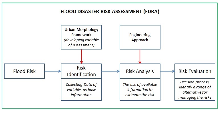
FDRA is a potential strategy to encourage people for understanding disaster risk capacity. It must be done periodically, continue, and sustainable to obtain good and strong data as baseline information for determining the best strategy for prevention and mitigation in community involved and spatial scale on ecosystems, according to national conditions (UN, 2015). Risk assessment in disaster-risk management framework will be conducted in the following action: 1) Risk identification; 2) Risk analysis; and 3) Risk evaluation (Van Westen, 2013). Results of risk analysis will be used as an important consideration in decision process on risk evaluation stage. Values and judgment in risk evaluation will be associated with social, environmental, and economic significance. A range of measures will be recognized as a result of risk evaluation to reduce the risks (UN-ISDR, 2004). Hence, the purpose of this study is developing guidance and tools of FDRA in urban disaster-risk management for reducing flood risk and enhancing risk knowledge of the communities.
Research Methods
Critical reviews are carried out on scientific papers published during the last five years and indexed by SCOPUS. The focus of the review is emphasized on the keywords that have been determined, namely: 1) Flood Risk; 2) Flood risk assessment; 3) urban morphology; dan 4) engineering approach. The conceptual of review guidance developed with a moderation approach (Figure 1) based on Van Westen (2013) model. The result of review is used to arrange guidance and tools of FDRA in urban morphology framework.
Findings
Risk identification
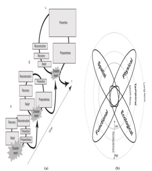
FDRA is developed based on an understanding of risk knowledge learned from past disasters (Figure 2a). In traditional concept of disaster-risk management has shown that risk level will depend on the interaction between hazard, exposure, dan vulnerability (Lyu, Shen, Zhou, & Yang, 2019; Van Westen, 2013). Lyu et al. (2019) have determined climate change and rapid urbanization will increase urban flood risk. The effect of climate change has to give consequences on hazard intensity and frequency (Lyu et al., 2019; Dhar & Khirfan, 2017). Berndtsson et al. (2019) have identified and qualitatively determined seven key drivers of changing flood risk which divided based on hazard and vulnerability drivers. Shi et al. (2019) identified precipitations as hazard parameters in assessment and used the last historical flood disaster data in risk analysis by simulation methods. Therefore, variable assessment of FDRA is determined to start from key drivers of urban flood risk which is divided in to 1) vulnerability; 2) capacity; 3) element at-risk/exposure of human and assets; and 4) hazard nature and habitat (Muis, Güneralp, Jongman, Aerts, & Ward, 2015 ; Shi et al., 2019; UN, 2015).
Variable assessment of FDRA developed in urban morphology framework to show interaction and coordination between urban design concept and flood disaster risk assessment. Dhar and Khirfan (2017) have given urban design concept that includes urban design interrelated with urban morphology components of the built environment. It is a potential concept for increasing the urban form resilience. This concept assesses four components which consist of ecological, functional, physical, and spatial. These four components are related to each other and influenced by time and scale (Figure 2b).
Drivers of flood risk and urban morphology components are used as basic concepts of FDRA to determine variable assessment. Variables assessment will be divided into four component which is developed from Dhar and Khirfan (2017) and Shi et al. (2019) (Table 1).
Risk analysis
Data availability from past disasters is collected to gain information and identify risk in urban morphology framework. The information from risk identification step is used as base information for risk analysis. Risk analysis is the focus in risk assessment process which is influenced by the available good and strong data. Engineering approach is using an assessment method that generally is defined into four types: 1) methods of statistics; 2) multi-criteria analysis; 3) GIS and RS techniques, and 4) scenario-based analysis.
Variable assessment and geographic scale will be determined the assessment method and study area scale. Various studies have shown how FDRA is conducted with different models and methodologies. FDRA comes in various term and different perspectives but it has in common, which is: 1) focused on risk analysis; 2) based on risk knowledge from past disasters; and 3) identified driver risk (hazard, vulnerability, and exposure) as basic approach (Table 2).
Conclusion
The stable escalation of disaster risk, including the raise of human and assets vulnerability, amalgamated with the experiences from past disasters, indicates to reinforce disaster preparedness for response and prevention measures. FDRA in urban morphology framework promotes progressive action for developing countries to adapt and to improve periodically disaster readiness and prevention. FDRA results can be used to determine risk level at the prone area, priority action in urban development to reduce impact when hazard occurred, and to enhance risk knowledge and participation of relevant stakeholders.
FDRA in urban morphology framework is still strategic and important for further development, especially in guidelines and tools for assessing land-use policy development and enforcement, including urban planning, land deterioration assessments, and informal and casual housing, which related to the physical environment and identified as the high impact in urban flood risk. Data availability is the highest challenge for FDRA. Data is important and crucial for gaining knowledge, risk assessment, scenario planning, and risk reduction practice. Engineering approach can be chosen as one of knowledge-based methodologies and instruments to account for and to analyze mass data as part of risk assessment. These results will be used to reinforce disaster risk modeling, assessment, mapping, monitoring, and multi-hazard early warning systems.
Integrating FDRA in urban planning development as part of preparedness program will enhance resilience community to face flood hazards. It can be implemented through response and recovery program after hazard. FDRA must be doing periodically, continue, and sustainable as part of risk-management cycle to enhance resilience factors. Furthermore, the intersection between urban morphology and risk assessment needs further development, especially for connecting it into the resilience framework.
Acknowledgments
The authors would like to acknowledge the Ministry of Education for the Fundamental Research Grant (FRGS) (Grant no: 203/PPBGN: 6711708) awarded to enable this research to be conducted and to the USM for giving the opportunity in obtaining the grant.
References
Aeron, A., Garg, R. D., Arsya, D. S., & Aggarwal, S. P. (2012). Advancements in Flood Risk Mapping Systems: A Brief Review. i-manager’s Journal on Civil Engineering, 2(1), 40–49. DOI:
Berndtsson, R., Becker, P., Persson, A., Aspegren, H., Haghighatafshar, S., Larsson, R., … & Scholz, M. (2019). Drivers of changing urban flood risk: A framework for action. Journal of Environmental Management, 240, 47–56. DOI:
Centre for Research on the Epidemiology of Disasters (CRED) and United Nations Office of Disaster Risk Reduction. (2018). Economic Loses, Poverty & Disasters 1998-2017. Retrieved from <https://www.preventionweb.net/files/61119_credeconomiclosses.pdf >
Dhar, T. K., & Khirfan, L. (2017). A multi-scale and multi-dimensional framework for enhancing the resilience of urban form to climate change. Urban Climate, 19, 72-91. DOI:
Harrison, C. G., & Williams, P. R. (2016). A Systems approach to natural disaster resilience. Simulation Modelling Practice and Theory, 65, 11-31. DOI:
Irajifar, L., Sipe, N., & Alizadeh, T. (2016). The impact of urban form on disaster resiliency: A case study of Brisbane and Ipswich, Australia. Int. Jou. Of Disaster Resilience in the Built Environment, 7(3), 259 – 275. DOI:
Kropf, K. (2005). The handling characteristics of urban form. Urban Design, 93, 17–18.
Lyu, H. M., Shen, S. L., Zhou, A., & Yang, J. (2019). Perspectives for flood risk assessment and management for mega-city metro system. Tunneling and Underground Space Technology, 84, 31-44. DOI:
Matsumaru, R. (2015). Reconstruction from the Indian Ocean Tsunami Disaster: Case Study of Indonesia and Sri Lanka and the Philosophy of “Build Back Better”. Handbook of Coastal Disaster Mitigation for Engineers and Planners, Chapter 27, 581 – 597. DOI:
Moghadas, M., Asadzadeh, A., Vafeidis, A., Fekete, A., & Kötter, T. (2019). A multi-criteria approach for assessing urban flood resilience in Tehran, Iran. International Journal of Disaster Risk Reduction, 35, 101069. DOI:
Muis, S., Güneralp, B., Jongman, B., Aerts, J. C. J. H., & Ward, P. J. (2015). Flood risk and adaptation strategies under climate change and urban expansion: A probabilistic analysis using global data. Science of The Total Environment, 538, 445-457. DOI:
Population Division of United Nations Department Economic and Social Affair (UN DESA). (2018). 2018 Revision of World Economic Situation and Prospects. Access from <https://population.un.org/wup/Publications/Files/WUP2018-KeyFacts.pdf >
Ran, J., & Nedovic-Budic, Z. (2016). Integrating spatial planning and flood risk management: A new conceptual framework for the spatially integrated policy infrastructure. Computers, Environment, and Urban Systems, 57, 68-79. DOI:
Rus, K., Kilar, V., & Koren, D. (2018) Resilience assessment of complex urban systems to natural disasters: A new literature review. International Journal of Disaster Risk Reduction, 31, 311–330. DOI:
Shi, Y., Zhai, G., Zou, S., Lu, Y., Chen, W., & Deng, J. (2019). How can cities respond to flood disaster risks under multi-scenario simulation? A case study of Xiamen China. Int. Journal of Environmental Research and Public Health, 16(4), 618. DOI:
Sitko, P. (2017). Urban Disaster Resilience: Learning from the 2011 Bangkok, Thailand, Flood using morphology and complex adaptive systems, Chapter 5 Urban Disaster Resilience: New Dimensions from International Practice in the Built Environment, Routledge, New York
Ungaro, F., Calzolari, C., Pistocchi, A., & Malucelli, F. (2014). Modelling the impact of increasing soil sealing on runoff coefficients at regional scale: a hydropedological approach. J. Hydrol. Hydromechanics, 62, 33–42. Retrieved from <https://www.degruyter.com/downloadpdf/j/johh.2014.62.issue-1/johh-2014-0005/johh-2014-0005.pdf>
United Nations of Disasters Risk Reduction. (2019). Global Assessment Report on Disaster Risk Reduction 2019. access from <https://gar.unisdr.org/part-i-sendai-frameworks-broadened-view-worlds-risk>
United Nations. (2015). Sendai framework 2015-2030. Retrieved from <https://www.unisdr.org/files/43291_sendaiframeworkfordrren.pdf>
United Nations of International Strategy for Disaster Reduction (UN-ISDR). (2004). Terminology of disaster risk reduction, United Nations, Internasional Strategy for Disaster Reduction, Geneva, Switzerland. Retrieved from http://www.unisdr.org/eng/library/lib-terminology-eng%20home.htm
Van Westen, C. J. (2013). Remote Sensing and GIS for Natural Hazards Assessment and Disaster Risk Management. Treatise on Geomorphological, 3, 259-298. DOI: 10.1016/B978-0-12-374739-6.00051-8
Warner, S., & Whittemore, A. (2012). American Urban Form: A Representative History. Cambridge: MIT Press.
Whitehand, J. (2012). Issues in urban morphology. Urban Morphology (16), 55–65. Retrieved from www.urbanform.org/online_public/2012_1.shtml
World Economic Forum (WEF). (2015). Inspiring Future Cities & Urban Services Shaping the Future of Urban Development and Services Initiative. Retrieved from http://www3.weforum.org/docs/WEF_Urban-Services.pdf
Copyright information

This work is licensed under a Creative Commons Attribution-NonCommercial-NoDerivatives 4.0 International License.
About this article
Publication Date
26 December 2017
Article Doi
eBook ISBN
978-1-80296-950-4
Publisher
Future Academy
Volume
2
Print ISBN (optional)
-
Edition Number
1st Edition
Pages
1-882
Subjects
Technology, smart cities, digital construction, industrial revolution 4.0, wellbeing & social resilience, economic resilience, environmental resilience
Cite this article as:
Nordin, J., Samad*, M. H. A., & Maulana, S. (2017). Flood Disaster Risk Assessment in Urban Morphology Framework to Enhance Resilience Factor. In P. A. J. Wahid, P. I. D. A. Aziz Abdul Samad, P. D. S. Sheikh Ahmad, & A. P. D. P. Pujinda (Eds.), Carving The Future Built Environment: Environmental, Economic And Social Resilience, vol 2. European Proceedings of Multidisciplinary Sciences (pp. 123-131). Future Academy. https://doi.org/10.15405/epms.2019.12.13